Maps of British Isles
Tabula Prima Europae [Hibernia und Albion Insula Britanica] [Karte], in: Claudii Ptolemei viri Alexandrini mathematice discipline philosophi doctissimi geographie opus [...], S. 151.
1 Karte aus Atlas Waldseemüller, Martin [und Ptolemaeus, Claudius] Übelin, Georg
Tabula Europae I. [Karte], in: Geographia universalis vetus et nova complectens Claudii Ptolemaei Alexandrini enarrationis libros VIII, S. 222.
1 Karte aus Atlas Münster, Sebastian [und Ptolemaeus, Claudius]
Tabula Europae I. [Karte], in: Claud. Ptolemaeus. Geographia lat. cum mappis [...], S. 254.
1 Karte aus Atlas Münster, Sebastian [und Ptolemaeus, Claudius]
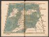
Die Britischen Inseln und das Umliegende Meer
Handatlas über alle Theile der Erde und über das Weltgebäude Stieler, Adolf Justus Perthes
Prima Europe Tabula [Karte], in: [Clavdii Ptholomei Cosmographi ...], S. 245.
1 Karte aus Atlas Nicolaus Germanus [und Ptolemaeus, Claudius]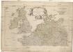
Erster Theil der Karte von Europa
1 : 2850000 Anglie Anville, Jean-Baptiste Bourguinon d' Schraembl, Franz Anton F.A. Schraembl
Erster Theil der Karte von Europa
1 : 2850000 Anglie Anville, Jean-Baptiste Bourguinon d' Schraembl, Franz Anton F.A. Schraembl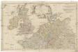
Erster Theil der Karte von Europa
1 : 2850000 Anglie Anville, Jean-Baptiste Bourguinon d' Schraembl, Franz Anton F.A. Schraembl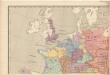
Evropa raného středověku: do konce VI. století po Kr.
Kašpar, Jan
British Isles - Physical Geography..
Milner, Thomas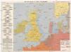
Kriegskarte der Nordsee
1 : 3350000 Severní moře-oblast Max Freissler
[123][126] Pascaert vande Noort-Zee om achter Yrland en Schotland om te seylen, uit: Atlas sive Descriptio terrarum orbis
Annotatie: Gedigitaliseerde versie. Amsterdam. Heiloo : Picturae (vervaardiger), 2015. tiff-bestand. Gedigitaliseerd: 07-01-2015; Origineel: Universiteitsbibliotheek Vrije Universiteit (XL.05127.-) ; Netherlands; Titelpagina ontbreekt Wit, Frederik de Amsterdam : Frederick de Wit
Westeuropa 2003
Westeuropa Kunz, Andreas ; Treiling, Thomas
Tidal Chart of the British Seas
The physical atlas Johnston, Alexander Keith William Blackwood & Sons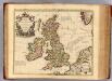
Isles Britanniques.
1 : 2500000 L'Isle, Guillaume de, 1675-1726
Westeuropa 1990
Westeuropa Kunz, Andreas ; Treiling, Thomas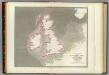
Tidal chart British Seas.
1 : 4900000 Russell, J. Scott (John Scott), 1808-1882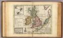
A general map of Great Britain and Ireland.
1 : 7500000 Moll, Herman, d. 1732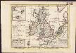
A general map of Great Britain and Ireland, with part of Germany, Holland, Flanders, France &c. agreeable to modern history
1 : 6500000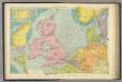
North Sea.
1 : 5000000 Philip, George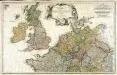
Erster Theil der Karte von Europa, welcher Frankreich, Deutschland, Italien Spanien, England, Scotland und Ireland enthælt, 1
1 Blatt : 53 x 83 cm F.A. Schrämbl
Erdkarte zur Übersicht des Kolonialbesitzes, der konsularischen und
1 : 50000000 Kiepert, Richard ; Limpricht, Max Geographische Verlagshandlung Dietrich Reimer
England, Schottland und Irland
Schul-Atlas in 36 Karten Völter, Daniel Verlag der J.M. Dannheimer'schen Buchhandlung
Die Britischen Inseln und das Umliegende Meer
Hand-Atlas über alle Theile der Erde und über das Weltgebäude Stieler, Adolf Justus Perthes
England und die Nordseeländer
1 : 3500000 Severní moře (oblast) Kartogr. Anst. Freytag & Berndt
Les Isles Britanniques : ou sont le royaumes d'Angleterre tiré de Speed, celuy d'Ecosse tiré de Th. Pont et celuy d'Irlande tiré de Petit / le tout rectifié par diverses observations par G. de l'Isle
1 : 2650000 titelvariant: Magnae Britanniae tabula; Annotatie: Titel boven de kaart: Magnae Britanniae tabula : comprehendens Angliae, Scotiae, ac Hiberniae regna, ad usum serenissimi Burgundiae Ducis; Oorspr. verschenen in: Atlas nouveau ... / par Guillaume de l'Isle. - Amsterdam : Jean Covens & Corneille Mortier, 1730 Isle, Guillaume de l' Amsteldam : I. Covens & C. Mortier
Carte pour l'intelligence de l'histoire d'Angleterre
1 Karte : Kupferdruck ; 26 x 26 cm, Bildgrösse 35 x 46 cm Châtelain s.n.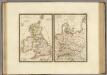
Iles Britanniques anciennes, Germanie ancienne, Rhetie, Pannonie, Norique.
1 : 3800000 Brue, Adrien Hubert, 1786-1832
Die Britischen Inseln und die Nord-See
Hand-Atlas über alle Theile der Erde nach dem neuesten Zustande und über das Weltgebäude Stieler, Adolf bei Justus Perthes
![Tabula Prima Europae [Hibernia und Albion Insula Britanica] [Karte], in: Claudii Ptolemei viri Alexandrini mathematice discipline philosophi doctissimi geographie opus [...], S. 151.](https://images-2.georeferencer.com/images/iiif/260174517146/full/,300/0/native.jpg)

