Maps of United Kingdom

Tabula Europae I. [Karte], in: Geographia universalis vetus et nova complectens Claudii Ptolemaei Alexandrini enarrationis libros VIII, S. 222.
1 Karte aus Atlas Münster, Sebastian [und Ptolemaeus, Claudius]
Tabula Europae I. [Karte], in: Claud. Ptolemaeus. Geographia lat. cum mappis [...], S. 254.
1 Karte aus Atlas Münster, Sebastian [und Ptolemaeus, Claudius]
Tabula Nova Hibernie Anglie Et Scotie [Karte], in: Claudii Ptolemei viri Alexandrini mathematice discipline philosophi doctissimi geographie opus [...], S. 236.
1 Karte aus Atlas Waldseemüller, Martin [und Ptolemaeus, Claudius] Übelin, Georg
Carte d'Europe ou sont tracées les limites des empires, royaumes, et etats souverains, feuille 3
1 Blatt : 65 x 95 cm Semen etc
Tabula Prima Europae [Hibernia und Albion Insula Britanica] [Karte], in: Claudii Ptolemei viri Alexandrini mathematice discipline philosophi doctissimi geographie opus [...], S. 151.
1 Karte aus Atlas Waldseemüller, Martin [und Ptolemaeus, Claudius] Übelin, Georg
Evropa raného středověku: do konce VI. století po Kr.
Kašpar, Jan
Prima Europe Tabula [Karte], in: [Clavdii Ptholomei Cosmographi ...], S. 245.
1 Karte aus Atlas Nicolaus Germanus [und Ptolemaeus, Claudius]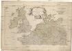
Erster Theil der Karte von Europa
1 : 2850000 Anglie Anville, Jean-Baptiste Bourguinon d' Schraembl, Franz Anton F.A. Schraembl
Erster Theil der Karte von Europa
1 : 2850000 Anglie Anville, Jean-Baptiste Bourguinon d' Schraembl, Franz Anton F.A. Schraembl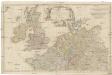
Erster Theil der Karte von Europa
1 : 2850000 Anglie Anville, Jean-Baptiste Bourguinon d' Schraembl, Franz Anton F.A. Schraembl
Die Britischen Inseln und das Umliegende Meer
Handatlas über alle Theile der Erde und über das Weltgebäude Stieler, Adolf Justus Perthes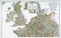
Prémière partie de la carte d'Europe contenant la France, l'Alemagne, l'Italie, l'Espagne & les isles britanniq.s, 1
1 Blatt : 53 x 84 cm s.n.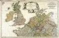
Erster Theil der Karte von Europa, welcher Frankreich, Deutschland, Italien Spanien, England, Scotland und Ireland enthælt, 1
1 Blatt : 53 x 83 cm F.A. Schrämbl
Westeuropa 1949
Westeuropa Kunz, Andreas ; Treiling, Thomas
British Isles - Physical Geography..
Milner, Thomas
Westeuropa 1890
Westeuropa Kunz, Andreas ; Röss, Wolf ; Johnen, Bettina ; Moeschl, Joachim Robert
Westeuropa 1861
Westeuropa Kunz, Andreas ; Röss, Wolf ; Johnen, Bettina ; Moeschl, Joachim Robert
Westeuropa 1914
Westeuropa Kunz, Andreas ; Röss, Wolf ; Johnen, Bettina ; Moeschl, Joachim Robert
Westeuropa 1937
Westeuropa Kunz, Andreas ; Treiling, Thomas
Westeuropa 1871
Westeuropa Kunz, Andreas ; Röss, Wolf ; Johnen, Bettina ; Moeschl, Joachim Robert
Westeuropa 1957
Westeuropa Kunz, Andreas ; Treiling, Thomas
Erdkarte zur Übersicht des Kolonialbesitzes, der konsularischen und
1 : 50000000 Kiepert, Richard ; Limpricht, Max Geographische Verlagshandlung Dietrich Reimer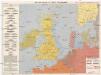
Kriegskarte der Nordsee
1 : 3350000 Severní moře-oblast Max Freissler
Westeuropa 1820
Westeuropa Kunz, Andreas ; Röss, Wolf ; Johnen, Bettina ; Moeschl, Joachim Robert
Westeuropa 1812
Westeuropa Kunz, Andreas ; Treiling, Thomas
Westeuropa 1830
Westeuropa Kunz, Andreas ; Röss, Wolf ; Johnen, Bettina ; Moeschl, Joachim Robert
Westeuropa 2003
Westeuropa Kunz, Andreas ; Treiling, Thomas
Westeuropa 1797
Westeuropa Kunz, Andreas ; Treiling, Thomas
[123][126] Pascaert vande Noort-Zee om achter Yrland en Schotland om te seylen, uit: Atlas sive Descriptio terrarum orbis
Annotatie: Gedigitaliseerde versie. Amsterdam. Heiloo : Picturae (vervaardiger), 2015. tiff-bestand. Gedigitaliseerd: 07-01-2015; Origineel: Universiteitsbibliotheek Vrije Universiteit (XL.05127.-) ; Netherlands; Titelpagina ontbreekt Wit, Frederik de Amsterdam : Frederick de Wit
![Tabula Europae I. [Karte], in: Geographia universalis vetus et nova complectens Claudii Ptolemaei Alexandrini enarrationis libros VIII, S. 222.](https://images-2.georeferencer.com/images/iiif/219344783626/full/,300/0/native.jpg)

