Maps of Suffolk

Pascaert vande Cust van Engelandt [...] [Karte], in: De Nieuwe Groote Vermeerderde Zee-Atlas ofte Water-Werelt, S. 39.
1 Karte aus Atlas Doncker, Hendrick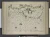
Zeekusten van Engelant, van't voorlant tot Blackeny, waerin oock is de rivier van London.
from De zee-atlas ofte water-wereld : waer in vertoont werden alle de zee-kusten van het bekende des aerd-bodems : seer dienstigh voor alle heeren en kooplieden, als oock voor alle schippers en stuurlieden / by Pieter Goos.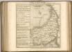

Ordnance Survey of England and Wales (Sheet 9), East Anglia
Ordnance Survey, Great Britain
A new travelling map of the country round London, 2
1 Blatt : 49 x 60 cm J. Andrews & A. Drury
Nordsee
1 : 150000 Anglie Reichs-Marine-Amt
L'abbrucciamento fatto da gli vascelli Olandesi di quelli de gli Inglesi nella réuéera di Cattam anno 1666 24 di agosto
Chatham (Anglie) Bouttats, Gerhaert
L'abbrucciamento fatto da gli vascelli Olandesi di quelli de gli Inglesi nella réuéera di Cattam anno 1666 24 di agosto
Chatham (Anglie) Bouttats, Gerhaert
Paskaert vande Zeeuse Vlaemse en Engelse Kusten [nordöstliche Küste] [Karte], in: De Nieuwe Groote Vermeerderde Zee-Atlas ofte Water-Werelt, S. 35.
1 Karte aus Atlas Doncker, Hendrick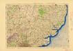
Ordnance Survey of England and Wales (Aeronautical map)
Great Britain. War Office. General Staff. Geographical Section [London] : [Air Ministry],
Nordsee
1 : 150000 Anglie Reichs-Marine-Amt
Sheet 9 Eastern Counties (S.), uit: Maps of England & Wales : scale 4 miles to 1 inch / Ordnance Survey
1 : 253440 titelvariant: Maps of England and Wales; Annotatie: Titel op cassette; Met bladoverzicht op de achterzijde van de cassette; Annotatie geografische gegevens: Hoogtelijneninterval 200 ft Ordnance Survey, United Kingdom Southampton : Ordnance Survey Office
Oostende, uit: [Choro-mineralogische en algemeene hijdrographische kaart van een gedeelte der Zuidelijke provincien van het Koningrijk der Nederlanden] / ontworpen en volgens onder eigene directie verrigte opnemingen vervaardigd ... door den generaal-majoor en directeur der militaire verkenningen J.E. van Gorkum
1 : 200000 titelvariant: Choro-mineralogische en algemeene hydrographische kaart van een gedeelte der Zuidelijke provincien van het Koningrijk der Nederlanden; Algemeene kaart der fundamenteele of hoofddriehoeken getrokken over de Zuidelijke provincien van het Koningrijk der Nederlanden; Verdeeelings-blad der geologische en mineralogische kaart van een zuidelijk gedeelte der Nederlanden; Annotatie: Titel op het blad Bapaume: Algemeene kaart der fundamenteele of hoofddriehoeken getrokken over de Zuidelijke provincien van het Koningrijk der Nederlanden : tevens aanwijzende de verdeeling der bladen van de voor de militaire zowel als de civiele dienst ingerigte Choro-mineralogische en algemeene hijdrographische kaart van een gedeelte dezer genoemde provincien op de schaal van 1 el voor 200.000 ellen; Titel van bijlageblad: Verdeeelings-blad der geologische en mineralogische kaart van een zuidelijk gedeelte der Nederlanden; Van het blad Chimay zijn twee staten aanwezig; Annotatie geografische gegevens: 4 schaalstokken (op het blad Chimay) Jan Egbert van Gorkum 1781-1862 [S.l. : Directie der Militaire Verkenningen]
To the Right Honourable the Master, Wardens, & Elder Bretham of the Trinity House, this chart of the entrances to The River Thames is ... dedicated
1 : 170000 Heather, W. (William) Heather, W. (William)
Suffolcia. Vernacule Suffolke. [Karte], in: Theatrum orbis terrarum, sive, Atlas novus, Bd. 4, S. 285.
1 Karte aus Atlas Blaeu, Joan Blaeu, Willem Janszoon
Ostende 67, uit: Special-Karte von Mittel-Europa / nach amtlichen Quellen bearbeitet von W. Liebenow
1 : 300000 titelvariant: W. Liebenow's Mittel-Europa; Annotatie: Titel boven de bladen: W. Liebenow's Mittel-Europa Johannes Wilhelm Liebenow 1822-1897 Frankfurt a. M. : Ludwig Ravenstein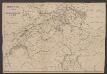
Suffolcia. Vernacule Suffolke. [Karte], in: Le théâtre du monde, ou, Nouvel atlas contenant les chartes et descriptions de tous les païs de la terre, Bd. 4, S. 253.
1 Karte aus Atlas Blaeu, Willem Janszoon und Blaeu, Joan Blaeu, Willem Janszoon
Suffolcia. Vernacule Suffolke. [Karte], in: Theatrum orbis terrarum, sive, Atlas novus, Bd. 4, S. 285.
1 Karte aus Atlas Blaeu, Joan Blaeu, Willem Janszoon
Ostende 67, uit: [W. Liebenow's Special-Karte von Mittel-Europa]
1 : 300000 titelvariant: W. Liebenow's Mittel-Europa; Annotatie: Titel boven de bladen: W. Liebenow's Mittel-Europa Johannes Wilhelm Liebenow 1822-1897 Hannover : Hermann Oppermann
Suffolcia vernacula Suffolke. [Karte], in: Novus atlas absolutissimus, Bd. 7, S. 276.
1 Karte aus Atlas Janssonius Offizin
Suffolcia vernacule Suffolke
1 : 240000 Joannes Janssonius excudit. [Amstelodami] : [apud Joannem Janssonium]
SVFFOLCIA. | Vernacule | SVFFOLKE.
[Amsterdam : Joan Blaeu]
SUFFOLCIAE Comitatus f.38
This is a map of Suffolk by Christopher Saxton which dates from 1576. It forms part of an atlas that belonged to William Cecil Lord Burghley, Elizabeth I’s Secretary of State, who used this atlas to illustrate domestic matters. This map is actually a proof copy of one which forms part of Christopher Saxton’s Atlas of England and Wales. This atlas was first published as a whole in 1579. It consists of 35 coloured maps depicting the counties of England and Wales. The atlas is of great significance to British cartography as it set a standard of cartographic representation in Britain and the maps remained the basis for English county mapping, with few exceptions, until after 1750. During the reign of Elizabeth I, map use became more common, with many government matters referring to increasingly accurate maps with consistent scales and symbols, made possible by advances in surveying techniques. Illustrating the increasing use of maps in government matters, Lord Burghley, who had been determined to have England and Wales mapped in detail from the 1550s, selected the cartographer Christopher Saxton to produce a detailed and consistent survey of the country. The financier of the project was Thomas Seckford Master of Requests at the Court of Elizabeth I, whose arms appear, along with the royal crest, on each map. This map, unlike many of the others in the series, is divided into administrative units called hundreds which are shown by areas of different coloured. Lord Burghley has added information to the map, particularly along the coast line, knowledge of which was vital for defence.The map was engraved by Lenaert Terwoot, one of a team of seven English and Flemish engravers employed to produce the copper plates for the atlas. Saxton, Christopher Terwoot, Lenaert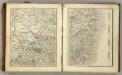
Sheets 35-36. (Cary's England, Wales, and Scotland).
1 : 360000 Cary, John, ca. 1754-1835
SUFFOLCIAE Comitatus Sheet 16
This map of Suffolk is from the 1583 edition of the Saxton atlas of England and Wales.This atlas was first published as a whole in 1579. It consists of 35 coloured maps depicting the counties of England and Wales. The atlas is of great significance to British cartography as it set a standard of cartographic representation in Britain and the maps remained the basis for English county mapping, with few exceptions, until after 1750. During the reign of Elizabeth I map use became more common, with many government matters referring to increasingly accurate maps with consistent scales and symbols, made possible by advances in surveying techniques. Illustrating the increasing used of maps in government matters, Lord Burghley, Elizabeth I’s Secretary of State, who had been determined to have England and Wales mapped in detail from the 1550s, selected the cartographer Christopher Saxton to produce a detailed and consistent survey of the country. The financier of the project was Thomas Seckford Master of Requests at the Court of Elizabeth I, whose arms appear, along with the royal crest, on each map. Saxton, Christopher Ryther, Augustine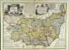
An accurate map of the county of Suffolk
1 Karte : Kupferdruck ; 50 x 69 cm Bowen; Hinton sold by I. Hinton at the Kings Arms in St. Pauls Church Yard
Suffolcia vernacula Suffolke
1 Karte : Kupferdruck ; 36 x 47 cm Valck; Schenk penes Gerardum Valk et Petrum Schenk
Svffolcia, vernacule Svffolke
1 Karte : Kupferdruck ; 37 x 48 cm Blaeu Joan Blaeu
Chart of the mouth of the River Thames, c1540
This map, showing parts of Kent and Sussex, comes from a 16th-century portfolio of coastal charts and drawings It incorporates miniature copies of town plans that are now lost including what are probably the earliest plans of Canterbury, Rochester and Sandwich The mapmaker was Sir Richard Cavendish With its emphasis on sandbanks and beaches, the map was evidently intended for navigation and defence purposes The decorative quality of the map suggests it was meant for the eyes of the king, Henry VIII North is to the left of the map and East to the top, making the map appear on its side to modern eyes Cavendish, Sir Richard
![Pascaert vande Cust van Engelandt [...] [Karte], in: De Nieuwe Groote Vermeerderde Zee-Atlas ofte Water-Werelt, S. 39.](https://images-2.georeferencer.com/images/iiif/598962763990/full/,300/0/native.jpg)

