Maps of Suffolk

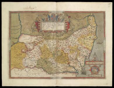
SUFFOLCIAE Comitatus f.38
This is a map of Suffolk by Christopher Saxton which dates from 1576. It forms part of an atlas that belonged to William Cecil Lord Burghley, Elizabeth I’s Secretary of State, who used this atlas to illustrate domestic matters. This map is actually a proof copy of one which forms part of Christopher Saxton’s Atlas of England and Wales. This atlas was first published as a whole in 1579. It consists of 35 coloured maps depicting the counties of England and Wales. The atlas is of great significance to British cartography as it set a standard of cartographic representation in Britain and the maps remained the basis for English county mapping, with few exceptions, until after 1750. During the reign of Elizabeth I, map use became more common, with many government matters referring to increasingly accurate maps with consistent scales and symbols, made possible by advances in surveying techniques. Illustrating the increasing use of maps in government matters, Lord Burghley, who had been determined to have England and Wales mapped in detail from the 1550s, selected the cartographer Christopher Saxton to produce a detailed and consistent survey of the country. The financier of the project was Thomas Seckford Master of Requests at the Court of Elizabeth I, whose arms appear, along with the royal crest, on each map. This map, unlike many of the others in the series, is divided into administrative units called hundreds which are shown by areas of different coloured. Lord Burghley has added information to the map, particularly along the coast line, knowledge of which was vital for defence.The map was engraved by Lenaert Terwoot, one of a team of seven English and Flemish engravers employed to produce the copper plates for the atlas. Saxton, Christopher Terwoot, Lenaert
Suffolcia vernacula Suffolke. [Karte], in: Novus atlas absolutissimus, Bd. 7, S. 276.
1 Karte aus Atlas Janssonius Offizin
Suffolcia. Vernacule Suffolke. [Karte], in: Theatrum orbis terrarum, sive, Atlas novus, Bd. 4, S. 285.
1 Karte aus Atlas Blaeu, Joan Blaeu, Willem Janszoon
Suffolcia. Vernacule Suffolke. [Karte], in: Le théâtre du monde, ou, Nouvel atlas contenant les chartes et descriptions de tous les païs de la terre, Bd. 4, S. 253.
1 Karte aus Atlas Blaeu, Willem Janszoon und Blaeu, Joan Blaeu, Willem Janszoon
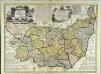
SUFFOLCIAE Comitatus Sheet 16
This map of Suffolk is from the 1583 edition of the Saxton atlas of England and Wales.This atlas was first published as a whole in 1579. It consists of 35 coloured maps depicting the counties of England and Wales. The atlas is of great significance to British cartography as it set a standard of cartographic representation in Britain and the maps remained the basis for English county mapping, with few exceptions, until after 1750. During the reign of Elizabeth I map use became more common, with many government matters referring to increasingly accurate maps with consistent scales and symbols, made possible by advances in surveying techniques. Illustrating the increasing used of maps in government matters, Lord Burghley, Elizabeth I’s Secretary of State, who had been determined to have England and Wales mapped in detail from the 1550s, selected the cartographer Christopher Saxton to produce a detailed and consistent survey of the country. The financier of the project was Thomas Seckford Master of Requests at the Court of Elizabeth I, whose arms appear, along with the royal crest, on each map. Saxton, Christopher Ryther, Augustine
Suffolcia. Vernacule Suffolke. [Karte], in: Theatrum orbis terrarum, sive, Atlas novus, Bd. 4, S. 285.
1 Karte aus Atlas Blaeu, Joan Blaeu, Willem Janszoon
Suffolcia vernacule Suffolke
1 : 240000 Joannes Janssonius excudit. [Amstelodami] : [apud Joannem Janssonium]
SVFFOLCIA. | Vernacule | SVFFOLKE.
[Amsterdam : Joan Blaeu]
An accurate map of the county of Suffolk
1 Karte : Kupferdruck ; 50 x 69 cm Bowen; Hinton sold by I. Hinton at the Kings Arms in St. Pauls Church Yard
Sheets 35-36. (Cary's England, Wales, and Scotland).
1 : 360000 Cary, John, ca. 1754-1835
Suffolcia vernacula Suffolke
1 Karte : Kupferdruck ; 36 x 47 cm Valck; Schenk penes Gerardum Valk et Petrum Schenk
Svffolcia, vernacule Svffolke
1 Karte : Kupferdruck ; 37 x 48 cm Blaeu Joan Blaeu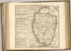
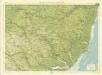
Suffolk, Sheet 20 - Bartholomew's "Half Inch to the Mile Maps" of England & Wales
1 : 126720 Topographic maps Bartholomew, John George John Bartholomew & Co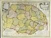
An accurate map of the county of Norfolk
1 Karte : Kupferdruck ; 52 x 70 cm Bowen; Hinton sold by I. Hinton at the Kings Arms in St. Pauls Church yard
Nortfolcia; vernacule Norfolke
1 Karte : Kupferdruck ; 36 x 47 cm Valck; Schenk penes Gerardum Valk et Petrum Schenk
Nortfolcia
1 Karte : Kupferdruck ; 37 x 48 cm Blaeu Joan Blaeu
A Coloured Chart of the Coast of Suffolk, from Orwell Haven to Gorlston, near Yarmouth
This is a map of the Suffolk coast stretching from Orwell Haven to Godeston near Yarmouth. It details the defences of the area may be part of the coastal survey of 1539. Fortification of large sections of coast was carried out at this time as Henry VIII feared an invasion from the combined forces of France and Spain. In 1538 Francis I of France, and Charles V Holy Roman Emperor and King of Spain signed a peace treaty. This union gave rise to the possibility that France and Spain may combine forces to invade England. France was England’s historical enemy and Henry VIII’s divorce of Catherine of Aragon, Charles V’s aunt, had offended the militantly catholic King of Spain. The map includes a vignette view of Ipswich, and a depiction of Orford Castle, built by Henry II in the 1160’s to guard what was then a busy port. Here a beacon is shown on the battlements, indicating that the castle, built on raised grown, has been incorporated into the early warning system that is depicted along the coast by numerous beacons. Two round tower forts are shown with gun ports and extended cannons. Such a large scale fortification plan was greatly aided by the significant advances in cartography and surveying which occurred in the Tudor period. The vast wealth Henry VIII had at his disposal after the dissolution of the monasteries provided the necessary finances for the survey.
Lowestoft - OS One-Inch Map
1 : 63360 Topographic maps Ordnance Survey Ordnance Survey
Bury St Edmunds - OS One-Inch Map
1 : 63360 Topographic maps Ordnance Survey Ordnance Survey
Feltwell St. Nicholas
1 : 31680 The pecked red line following the course of the Little Ouse marks the county boundary of Norfolk and Cambridgeshire. Drawn on the left of the sheet, along the Ouse Valley, is a patchwork of arable land divided by straight water-filled dykes, typical features of the fens landscape. This elaborate system of drains and river diversions was designed in the 17th century by a Dutch engineer called Vermuyden. It made possible the conversion of pasture to arable land in this region. Yeakell, Thomas
Bury St Edmunds
The landscape here still reflected its medieval character in the early nineteeth century, as is seen through the dominance of named common fields, heaths and warrens. Eldon Field, Downham Warren, and Cutford Heath are just a few of the large labelled tracts of land appearing on this map. Stanley, William.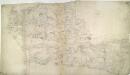
E. Harling
1 : 31680 The words 'Trig Point' are noted to the far left of the drawing, below Bodney. They indicate points from which angular measurements were taken in order to plot accurately the location of prominent landscape features. The pencil interlining ('hachuring') and shading that indicate relief have been lightly applied, leaving the road network clearly visible. The detail with which the roads are rendered is indicative of the Ordnance Survey's military imperative. Metcalf, Edward B.
Orford(002OSD000000026U00278000)
1 : 31680 This is an original protraction of the Suffolk coastline, running inland,from Orford Ness,,on the right,,to Hasketon and Wickham., The various traverses (single lines surveyed from different points),are distinguished by colour: red, blue, yellow, light brown and dark brown. ,These skeleton protraction lines,form the first plottings from the field book of the area., At the bottom right, the plan is annotated in blue with the date of the traverse and the,corresponding page numbers in the field book. Metcalf, Edward B
Orford(002OSD000000026U00277000)
1 : 31680 This partly finished plan of the Suffolk coastline shows only roads and settlements to the left, but land use and relief detail have been added to the right. Original protraction lines remain in pencil: these represent the first plottings from the field book of the area. The handwritten note pasted at the bottom of the plan may have been trimmed from the margin. Metcalf, Edward B
A Coloured Chart of the Coast of Essex and Suffolk, from the Naze to Bawdsey
This is a chart showing Essex and Suffolk from the Naze to Bawdsey showing the course of the Stour, Orwell, and Deben. It is thought to date from between 1539 and 1544. It shows miniaturized views of towns such as Ipswich and Harwich against a generalized green landscape of fields and occasional trees. The coast line and waterways are the main preoccupation of the cartographer as he has carefully recorded areas of sand in pink with stippled markings, and at certain points the depths of the water at low tide in area is noted. The cartographer is Richard Cavendish, whose family home in Suffolk is indicated. Richard Cavendish was a master gunner who had supervised new defence works at Berwick and Wark in 1522-3. It is thought that this map was based on a survey that Cavendish was paid to undertake in 1523. The date exact date of the map is uncertain. It could date from around 1538-9, a period characterised by the threat of invasion after a peace treaty was signed by Francis I of France and Charles V, Holy Roman Emperor and King of Spain in 1538. England and France were ancient enemies and the catholic Charles V, nephew of Catherine of Aragon, was angered by Henry VIII’s decision to divorce her. However, the presence of a scale bar in the bottom right corner suggests a date of post 1540. In 1543 war with France resumed and England was threatened by invasion once again. This map may be related to a large map which is referred to in Henry VIII’s inventory of 1547-80 the description of parte of Suffolke, Essexe and London painted upon clothe’ Cavendish, Richard
Colchester - OS One-Inch Map
1 : 63360 Topographic maps Ordnance Survey Ordnance Survey
Ipswitch - OS One-Inch Map
1 : 63360 Topographic maps Ordnance Survey Ordnance Survey