Maps of Bremen
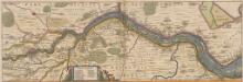
Nobilis Saxoniae Fl. Visurgis, cum Terris adjacentib. Ab Inclyta Brema, ad ostium maris. [Karte, Teil 1], in: Novus atlas absolutissimus, Bd. 2, S. 100.
1 Karte aus Atlas Janssonius Offizin
56. Bremen, uit: Topographische Uebersichtskarte des Deutschen Reiches / herausgegeben v. d. Kartogr. Abt. d. Königl. Preuß. Landesaufnahme
1 : 200000 titelvariant: Topogr. Übersichtskarte des Deutschen Reiches; Annotatie: Titel boven bladen ook: Topogr. Übersichtskarte des Deutschen Reiches; Annotatie geografische gegevens: Op elk blad twee maatstokken: 10 Kilometer = 5,5 cm; 1 geogr. Meile = 3,6 cm; Legenda onder op elk blad Königlich Preußische Landesaufnahme. Kartographische Abtheilung [S.l : Königlich Preußische Landesaufnahme, Kartographische Abtheilung]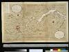
Afteekening van de rivier de Weeser, van de stad Brema tot 't eijland Hamelwerdersand in 't groodt
Germany Gerard van Keulen
206. Bremen. (Germany)
1 : 100000 Reichsamt fur Landesaufnahme
Composite: 175. Brake. (Germany)
1 : 100000 Reichsamt fur Landesaufnahme
175. Brake. (Germany)
1 : 100000 Reichsamt fur Landesaufnahme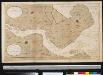
Afteekening van de rivier de Weeser van 't eijland Hamelweerdersand tot aan de Swarten Gronden in 't groot
Germany Gerard van Keulen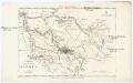
Charte der freien Stadt Bremen nebst Gebiet
1 : 85000 Brémy (Německo : oblast) Schlieben Gleditsch
Prospect und Grundris der Keisrl. Freyen REichs und Ansee Stadt Bremen samt ihrer Gegend
1 : 30000 Mollova mapová sbírka Homann, Johann Baptist Homann, Johann Baptista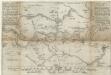
Eigendliche anweisung wie deß heiligen Reichss Statt Bremen in diesen 1666 Jahre von 30 Augusti biß den 15 Novemb.
1 : 50000 Mollova mapová sbírka Schultz, C.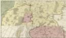
Comitatus Oldenburgensis]
Mollova mapová sbírka Loon, Jan van Schenk, Peter I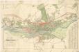
Plan von Bremen

Messtischblatt 1452 : Hemelingen, 1934 Hemelingen
1 : 250000 Hemelingen. - Hrsg. 1898, bericht. 1913, einz. Nachtr. 1925. - 1:25000. - [Berlin]: Reichsamt für Landesaufnahme, 1934. - 1 Kt.
Messtischblatt 1452 : Hemelingen, 1916 Hemelingen
1 : 250000 Hemelingen. - Aufn. 1897, hrsg. 1898, Auflagedr. 1916. - 1:25000. - [Berlin]: Reichsamt für Landesaufnahme, 1916. - 1 Kt.
Messtischblatt 1452 : Hemelingen, 1898 Hemelingen
1 : 250000 Hemelingen. - Aufn. 1897. - 1:25000. - [Berlin]: Reichsamt für Landesaufnahme, 1898. - 1 Kt.
Messtischblatt 1451 : Bremen, 1935 Bremen
1 : 250000 Bremen. - Hrsg. 1900, bericht. 1913, einz. Nachtr. 1926. - 1:25000. - [Berlin]: Reichsamt für Landesaufnahme, 1935. - 1 Kt.
Messtischblatt 1451 : Bremen, 1916 Bremen
1 : 250000 Bremen. - Aufn. 1898, hrsg. 1900, Aufldr. 1916. - 1:25000. - [Berlin]: Reichsamt für Landesaufnahme, 1916. - 1 Kt.
Messtischblatt 1451 : Bremen, 1900 Bremen
1 : 250000 Bremen. - Aufn. 1898, hrsg. 1900. - 1:25000. - [Berlin]: Reichsamt für Landesaufnahme, 1900. - 1 Kt.
Messtischblatt 1450 : Delmenhorst, 1934 Delmenhorst
1 : 250000 Delmenhorst. - Hrsg. 1900, bericht. 1913, einz. Nachtr. 1925. - 1:25000. - [Berlin]: Reichsamt für Landesaufnahme, 1934. - 1 Kt.
Messtischblatt 1449 : Kirchhatten, 1900 Kirchhatten
1 : 250000 Kirchhatten. - Aufn. 1898. - 1:25000. - [Berlin]: Reichsamt für Landesaufnahme, 1900. - 1 Kt.
Meßtischblatt 1372 : Lilienthal, 1933
1 : 250000 Lilienthal. - Hrsg. 1899, bericht. 1913. - 1:25000. - [Berlin]: Reichsamt für Landesaufnahme, 1933. - 1 Kt.
Meßtischblatt 1371 : Lesum, 1933
1 : 250000 Lesum. - Hrsg. 1900, bericht. 1913, einz. Nachtr. 1925. - 1:25000. - [Berlin]: Reichsamt für Landesaufnahme, 1933. - 1 Kt.
Meßtischblatt 1370 : Vegesack, 1934
1 : 250000 Vegesack. - Hrsg. 1900, bericht. 1913, einz. Nachtr. 1925. - 1:25000. - [Berlin]: Reichsamt für Landesaufnahme, 1934. - 1 Kt.
Meßtischblatt 1369 : Berne, 1934
1 : 250000 Berne. - Hrsg. 1900, bericht. 1913, einz. Nachtr. 1925. - 1:25000. - [Berlin]: Reichsamt für Landesaufnahme, 1934. - 1 Kt.
Meßtischblatt 1291 : Worpswede, 1935
1 : 250000 Worpswede. - Hrsg. 1899, bericht. 1913. - 1:25000. - [Berlin]: Reichsamt für Landesaufnahme, 1935. - 1 Kt.
Meßtischblatt 1291 : Worpswede, 1899
1 : 250000 Worpswede. - Aufn. 1897. - 1:25000. - [Berlin]: Reichsamt für Landesaufnahme, 1899. - 1 Kt.
Meßtischblatt 1290 : Osterholz, 1916
1 : 250000 Osterholz. - Aufn. 1898, hrsg. 1900, Auflagedr. 1916. - 1:25000. - [Berlin]: Reichsamt für Landesaufnahme, 1916. - 1 Kt.
Meßtischblatt 1289 : Schwanewede, 1900
1 : 250000 Schwanewede. - Aufn. 1898. - 1:25000. - [Berlin]: Reichsamt für Landesaufnahme, 1900. - 1 Kt.
Meßtischblatt 1288 : Elsfleth, 1917
1 : 250000 Elsfleth. - Aufn. 1898, hrsg. 1900, Auflagedr. 1917. - 1:25000. - [Berlin]: Reichsamt für Landesaufnahme, 1917. - 1 Kt.
![Nobilis Saxoniae Fl. Visurgis, cum Terris adjacentib. Ab Inclyta Brema, ad ostium maris. [Karte, Teil 1], in: Novus atlas absolutissimus, Bd. 2, S. 100.](https://images-2.georeferencer.com/images/iiif/608495176332/full/,300/0/native.jpg)

