Maps of Hatten

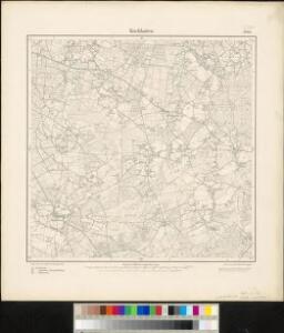
Messtischblatt 1449 : Kirchhatten, 1900 Kirchhatten
1 : 250000 Kirchhatten. - Aufn. 1898. - 1:25000. - [Berlin]: Reichsamt für Landesaufnahme, 1900. - 1 Kt.
206. Bremen. (Germany)
1 : 100000 Reichsamt fur Landesaufnahme
205. Oldenburg. (Germany)
1 : 100000 Reichsamt fur Landesaufnahme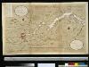
Afteekening van de rivier de Weeser, van de stad Brema tot 't eijland Hamelwerdersand in 't groodt
Germany Gerard van Keulen
Composite: 206. Bremen. (Germany)
1 : 100000 Reichsamt fur Landesaufnahme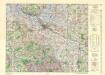
Central Europe 1:1,000,000, Bremen
Sheet M3 of the 287 sheet series: Central Europe. 1 : 100,000. G.S.G.S. No. 4416. AMS. M641, M651, M671. [London?] ; Washington, D.C. : War Office : Army Map Service, U.S. Army.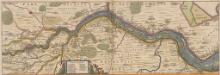
Nobilis Saxoniae Fl. Visurgis, cum Terris adjacentib. Ab Inclyta Brema, ad ostium maris. [Karte, Teil 1], in: Novus atlas absolutissimus, Bd. 2, S. 100.
1 Karte aus Atlas Janssonius Offizin
56. Bremen, uit: Topographische Uebersichtskarte des Deutschen Reiches / herausgegeben v. d. Kartogr. Abt. d. Königl. Preuß. Landesaufnahme
1 : 200000 titelvariant: Topogr. Übersichtskarte des Deutschen Reiches; Annotatie: Titel boven bladen ook: Topogr. Übersichtskarte des Deutschen Reiches; Annotatie geografische gegevens: Op elk blad twee maatstokken: 10 Kilometer = 5,5 cm; 1 geogr. Meile = 3,6 cm; Legenda onder op elk blad Königlich Preußische Landesaufnahme. Kartographische Abtheilung [S.l : Königlich Preußische Landesaufnahme, Kartographische Abtheilung]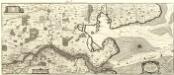
Nobilis Saxoniae Fl. Visvrgis cum Terris adjacentib. Ab Inclyta Brema ad Ostium Maris
1 : 130000 Mollova mapová sbírka Merian, Matthaeus Merian, Matthäus - dědici
Comitatvvm Oldenbvrg et Delmenhorst
1 : 166000 Oldenburg (Německo) Hunrichs, Johann Wilhelm Anton Münnich, Anton Günther von Homannianorum heredum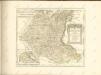

Comitatvvm Oldenbvrg et Delmenhorst
1 : 170000 Mollova mapová sbírka Hunrichs, Johann Wilhelm Anton Homann, Johann Baptista - dědici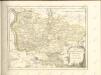


Bremen 44, uit: Special-Karte von Mittel-Europa / nach amtlichen Quellen bearbeitet von W. Liebenow
1 : 300000 titelvariant: W. Liebenow's Mittel-Europa; Annotatie: Titel boven de bladen: W. Liebenow's Mittel-Europa Johannes Wilhelm Liebenow 1822-1897 Frankfurt a. M. : Ludwig Ravenstein
OLDENBVRG | COMITATVS.
E. Sijmonsz. Hamersveldt sculp. [Amsterdam : Joan Blaeu]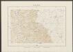
Oldenburg Comitatus [Karte], in: Theatrum orbis terrarum, sive, Atlas novus, Bd. 1, S. 200.
1 Karte aus Atlas Blaeu, Joan Blaeu, Willem Janszoon
Nobilis Saxoniae Fl. Visurgis, cum Terris adjacentib.
1 : 110000 Mollova mapová sbírka Loon, Jan van Schenk, Peter I
Nobilis Saxoniae Fl. Visurgis, cum Terris adjacentib.
1 : 110000 Mollova mapová sbírka Loon, Jan van Janssonius, Johannes I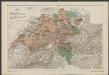
Oldenburg Comitatus [Karte], in: Gerardi Mercatoris et I. Hondii Newer Atlas, oder, Grosses Weltbuch, Bd. 1, S. 155.
1 Karte aus Atlas Mercator, Gerhard und Hondius, Jodocus Jansson, Jan
Oldenburg Comitatus [Karte], in: Le théâtre du monde, ou, Nouvel atlas contenant les chartes et descriptions de tous les païs de la terre, Bd. 1, S. 154.
1 Karte aus Atlas Blaeu, Willem Janszoon und Blaeu, Joan Blaeu, Willem Janszoon
Bremen 44, uit: [W. Liebenow's Special-Karte von Mittel-Europa]
1 : 300000 titelvariant: W. Liebenow's Mittel-Europa; Annotatie: Titel boven de bladen: W. Liebenow's Mittel-Europa Johannes Wilhelm Liebenow 1822-1897 Hannover : Hermann Oppermann
Oldenburg Comitatus [Karte], in: Novus Atlas, das ist, Weltbeschreibung, Bd. 1, S. 123.
1 Karte aus Atlas Blaeu, Joan Blaeu, Willem Janszoon
Oldenbvrg Comit.
1 : 250000 Mollova mapová sbírka Michaelis, Laurentius Plantin, Christoph
Oldenburg Comitatus [Karte], in: Novus atlas absolutissimus, Bd. 2, S. 109.
1 Karte aus Atlas Janssonius Offizin
Le Theatre de Bellone :
Mollova mapová sbírka Schenk, Pieter Braakman, Adriaan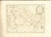

Oldenbvrg Comitatvs.
1 : 190000 Mollova mapová sbírka Aveele, Johannes van den
Oldenbvrg Comitatvs
1 : 190000 Mollova mapová sbírka Aveele, Johannes van den