Maps of Achim

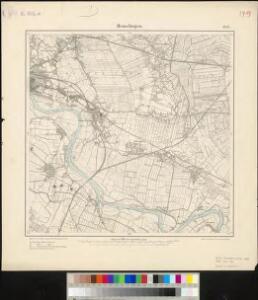
Messtischblatt 1452 : Hemelingen, 1934 Hemelingen
1 : 250000 Hemelingen. - Hrsg. 1898, bericht. 1913, einz. Nachtr. 1925. - 1:25000. - [Berlin]: Reichsamt für Landesaufnahme, 1934. - 1 Kt.
Messtischblatt 1452 : Hemelingen, 1916 Hemelingen
1 : 250000 Hemelingen. - Aufn. 1897, hrsg. 1898, Auflagedr. 1916. - 1:25000. - [Berlin]: Reichsamt für Landesaufnahme, 1916. - 1 Kt.
Messtischblatt 1452 : Hemelingen, 1898 Hemelingen
1 : 250000 Hemelingen. - Aufn. 1897. - 1:25000. - [Berlin]: Reichsamt für Landesaufnahme, 1898. - 1 Kt.
Prospect und Grundris der Keisrl. Freyen REichs und Ansee Stadt Bremen samt ihrer Gegend
1 : 30000 Mollova mapová sbírka Homann, Johann Baptist Homann, Johann Baptista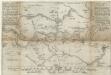
Eigendliche anweisung wie deß heiligen Reichss Statt Bremen in diesen 1666 Jahre von 30 Augusti biß den 15 Novemb.
1 : 50000 Mollova mapová sbírka Schultz, C.
Composite: 207. Ottersberg. (Germany)
1 : 100000 Reichsamt fur Landesaufnahme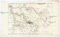
Charte der freien Stadt Bremen nebst Gebiet
1 : 85000 Brémy (Německo : oblast) Schlieben Gleditsch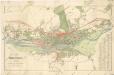
Plan von Bremen

Prospect und Grundris der keiserl. freyen Reichs und Ansee Stadt Bremen samt ihrer Gegend
Brémy (Německo) Seutter, Matthäus Homann, Johann Baptist Ioh. Bapt. Homann
Prospect und Grundris der keiserl. freyen Reichs und Ansee Stadt Bremen samt ihrer Gegend
Brémy (Německo) Homann, Johann Baptist Adrichem, Christiaan van Ioh. Bapt. Homann
Prospect und Grundris der keiserl. freyen Reichs und Ansee Stadt Bremen samt ihrer Gegend
Brémy (Německo) Homann, Johann Baptist Ioh. Bapt. Homann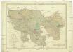
Karte des Gebiethes der Reichs und Hanse Stadt Bremen
1 : 39400 Brémy (Německo) Heineken, Christian Abraham Tischbein, Georg Heinrich
207. Ottersberg. (Germany)
1 : 100000 Reichsamt fur Landesaufnahme
Composite: 206. Bremen. (Germany)
1 : 100000 Reichsamt fur Landesaufnahme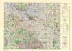
Central Europe 1:1,000,000, Bremen
Sheet M3 of the 287 sheet series: Central Europe. 1 : 100,000. G.S.G.S. No. 4416. AMS. M641, M651, M671. [London?] ; Washington, D.C. : War Office : Army Map Service, U.S. Army.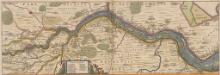
Nobilis Saxoniae Fl. Visurgis, cum Terris adjacentib. Ab Inclyta Brema, ad ostium maris. [Karte, Teil 1], in: Novus atlas absolutissimus, Bd. 2, S. 100.
1 Karte aus Atlas Janssonius Offizin
56. Bremen, uit: Topographische Uebersichtskarte des Deutschen Reiches / herausgegeben v. d. Kartogr. Abt. d. Königl. Preuß. Landesaufnahme
1 : 200000 titelvariant: Topogr. Übersichtskarte des Deutschen Reiches; Annotatie: Titel boven bladen ook: Topogr. Übersichtskarte des Deutschen Reiches; Annotatie geografische gegevens: Op elk blad twee maatstokken: 10 Kilometer = 5,5 cm; 1 geogr. Meile = 3,6 cm; Legenda onder op elk blad Königlich Preußische Landesaufnahme. Kartographische Abtheilung [S.l : Königlich Preußische Landesaufnahme, Kartographische Abtheilung]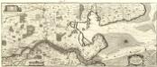
Nobilis Saxoniae Fl. Visvrgis cum Terris adjacentib. Ab Inclyta Brema ad Ostium Maris
1 : 130000 Mollova mapová sbírka Merian, Matthaeus Merian, Matthäus - dědici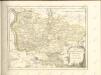


Nobilis Saxoniae Fl. Visurgis, cum Terris adjacentib.
1 : 110000 Mollova mapová sbírka Loon, Jan van Schenk, Peter I
Nobilis Saxoniae Fl. Visurgis, cum Terris adjacentib.
1 : 110000 Mollova mapová sbírka Loon, Jan van Janssonius, Johannes I
Bremen 44, uit: [W. Liebenow's Special-Karte von Mittel-Europa]
1 : 300000 titelvariant: W. Liebenow's Mittel-Europa; Annotatie: Titel boven de bladen: W. Liebenow's Mittel-Europa Johannes Wilhelm Liebenow 1822-1897 Hannover : Hermann Oppermann
Le Theatre de Bellone :
Mollova mapová sbírka Schenk, Pieter Braakman, Adriaan
Oldenbvrg Comitatvs.
1 : 190000 Mollova mapová sbírka Aveele, Johannes van den
Oldenbvrg Comitatvs
1 : 190000 Mollova mapová sbírka Aveele, Johannes van den
Comitatus Oldenburgici ac Delmenhorstani Sceptro Danico parentis Mappa specialissima Chorographica, novaq; recentissima
1 : 240000 Mollova mapová sbírka Rizzi Zannoni, Giovanni Antonio Seutter, Albrecht Carl
Carte topographique d'Allemagne
1 : 225000 Brémy (Německo) Jaeger, Johann Wilhelm Abraham Berndt, Johann Christoph I.W.A. Iaeger
Oldenburg Comit. [Karte], in: Theatrum orbis terrarum, S. 213.
1 Karte aus Atlas Ortelius, Abraham Vrients, Jan Baptista