Maps of Hertfordshire

Buckingamiae Comitatus cum Bedfordiensi; vulgo Buckingamshire and Bedfordshire. [Karte], in: Novus atlas absolutissimus, Bd. 7, S. 239.
1 Karte aus Atlas Janssonius Offizin
Buckingamiae comitatus cum Bedfordiensi, vulgo Buckingamshire and Bedfordfhire
1 : 180000 Amstelodami : apud Joannem Janssonium
Buckinghamiensis Comitatus; Anglis Buckingham Shire. [Karte], in: Theatrum orbis terrarum, sive, Atlas novus, Bd. 4, S. 247.
1 Karte aus Atlas Blaeu, Joan Blaeu, Willem Janszoon
Buckinghamiensis Comitatus; Anglis Buckingham Shire. [Karte], in: Le théâtre du monde, ou, Nouvel atlas contenant les chartes et descriptions de tous les païs de la terre, Bd. 4, S. 219.
1 Karte aus Atlas Blaeu, Willem Janszoon und Blaeu, Joan Blaeu, Willem Janszoon
Buckinghamiensis Comitatus; Anglis Buckingham Shire. [Karte], in: Theatrum orbis terrarum, sive, Atlas novus, Bd. 4, S. 247.
1 Karte aus Atlas Blaeu, Joan Blaeu, Willem Janszoon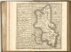

Oxonii, buckinghamiae et berceriae comitatum
This is a map of Oxfordshire, Buckinghamshire and Berkshire by Christopher Saxton which dates from 1574. It forms part of an atlas that belonged to William Cecil Lord Burghley, Elizabeth I’s Secretary of State. Burghley used this atlas to illustrate domestic matters. This map is actually a proof copy of one which forms part of Christopher Saxton’s Atlas of England and Wales. This atlas was first published as a whole in 1579. It consists of 35 coloured maps depicting the counties of England and Wales. The atlas is of great significance to British cartography as it set a standard of cartographic representation in Britain and the maps remained the basis for English county mapping, with few exceptions, until after 1750. During the reign of Elizabeth I, map use became more common, with many government matters referring to increasingly accurate maps with consistent scales and symbols, made possible by advances in surveying techniques. Illustrating the increasing use of maps in government matters, Lord Burghley, who had been determined to have England and Wales mapped in detail from the 1550s, selected the cartographer Christopher Saxton to produce a detailed and consistent survey of the country. The financier of the project was Thomas Seckford Master of Requests at the Court of Elizabeth I, whose arms appear, along with the royal crest on each map. Lord Burghley has added several place names to the map. The name of the engraver of the map has not been included but would have been one of a team of seven English and Flemish engravers employed to produce the copper plates for the atlas. Saxton, Christopher
Oxonii, buckinghamiae et berceriae Comitatuum
This map of Oxfordshire and the neighbouring counties of Buckinghamshire and Berkshire is from the 1583 edition of the Saxton atlas of England and Wales. This atlas was first published as a whole in 1579. It consists of 35 coloured maps depicting the counties of England and Wales. The atlas is of great significance to British cartography as it set a standard of cartographic representation in Britain and the maps remained the basis for English county mapping, with few exceptions, until after 1750. During the reign of Elizabeth I map use became more common, with many government matters referring to increasingly accurate maps with consistent scales and symbols, made possible by advances in surveying techniques. Illustrating the increasing used of maps in government matters, Lord Burghley, Elizabeth I’s Secretary of State, who had been determined to have England and Wales mapped in detail from the 1550s, selected the cartographer Christopher Saxton to produce a detailed and consistent survey of the country. The financier of the project was Thomas Seckford Master of Requests at the Court of Elizabeth I, whose arms appear, along with the royal crest, on each map. Saxton, Christopher Ryther, Augustine
Buckingamiæ comitatvs cum Bedfordiensi; vulgo Buckingamshire and Bedfordshire
1 Karte : Kupferdruck ; 38 x 48 cm Valck; Schenk penes Gerardum Valk et Petrum Schenk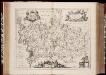
Middelsexiae cum Hertfordiae comitatu: = Midlesex & Hertford Shire / [Joannes Janssonius]
1 : 165000 titelvariant: Midlesex & Hertford Shire; Annotatie: Oorspr. verschenen in: Ioannis Ianssonii Novus atlas ... - Amstelodami : apud Iohannem Ianssonium, 1646; Origineel is Blad 27 in atlas factice; Annotatie geografische gegevens: West boven Janssonius, Joannes (jr.) (1588-1664) Amstelodami : apud Ioannem Ianssonium
Middelsexiae cum Hertfordiae comitatu: Midlesex & Hertford Shire. [Karte], in: Novus atlas absolutissimus, Bd. 7, S. 246.
1 Karte aus Atlas Janssonius Offizin
Middelsexiae cum Hertfordiae Comitatu = Midlesex & Hertford Shire
1 : 160000 Amstelodami : apud Joannem Janssonium
Middelsexiæ cum Hertfordiæ comitatu
1 Karte : Kupferdruck ; 42 x 52 cm Valck; Schenk apud G. Valk et P. Schenk
An accurate map of Buckingham Shire
1 Karte : Kupferdruck ; 69 x 52 cm Bowen; Tinney; Bowles; Sayer; Bowles; Bowles sold by I. Tinney at the golden lion and R. Sayer at the golden buck in Fleet street T. Bowles in St. Pauls Church yard and I. Bowles and son in Cornhill
Hertfordia comitatvs vernacule Hertfordshire
1 Karte : Kupferdruck ; 37 x 48 cm Blaeu Joan Blaeu
Oxonium Comitatus, Vulgo Oxford Shire. [Karte], in: Theatrum orbis terrarum, sive, Atlas novus, Bd. 4, S. 237.
1 Karte aus Atlas Blaeu, Joan Blaeu, Willem Janszoon
Oxonium Comitatus, Vulgo Oxford Shire. [Karte], in: Le théâtre du monde, ou, Nouvel atlas contenant les chartes et descriptions de tous les païs de la terre, Bd. 4, S. 209.
1 Karte aus Atlas Blaeu, Willem Janszoon und Blaeu, Joan Blaeu, Willem Janszoon
Oxonium Comitatus, Vulgo Oxford Shire. [Karte], in: Theatrum orbis terrarum, sive, Atlas novus, Bd. 4, S. 237.
1 Karte aus Atlas Blaeu, Joan Blaeu, Willem Janszoon
Bedford, Hertford, Sheet 25 - Bartholomew's "Half Inch to the Mile Maps" of England & Wales
1 : 126720 Topographic maps Bartholomew, John George John Bartholomew & Co
Hertfordia Comitatus. Vernacule Hertfordshire [Karte], in: Theatrum orbis terrarum, sive, Atlas novus, Bd. 4, S. 254.
1 Karte aus Atlas Blaeu, Joan Blaeu, Willem Janszoon
Bedfordiensis Comitatus; Anglis Bedford Shire. [Karte], in: Theatrum orbis terrarum, sive, Atlas novus, Bd. 4, S. 246.
1 Karte aus Atlas Blaeu, Joan Blaeu, Willem Janszoon
Herfordia Comitatus. Vernacule Hertfordshire [Karte], in: Le théâtre du monde, ou, Nouvel atlas contenant les chartes et descriptions de tous les païs de la terre, Bd. 4, S. 226.
1 Karte aus Atlas Blaeu, Willem Janszoon und Blaeu, Joan Blaeu, Willem Janszoon
Hertfordia Comitatus. Vernacule Hertfordshire [Karte], in: Theatrum orbis terrarum, sive, Atlas novus, Bd. 4, S. 254.
1 Karte aus Atlas Blaeu, Joan Blaeu, Willem Janszoon
Bedfordiensis Comitatus; Anglis Bedford Shire. [Karte], in: Theatrum orbis terrarum, sive, Atlas novus, Bd. 4, S. 246.
1 Karte aus Atlas Blaeu, Joan Blaeu, Willem Janszoon
Bedfordiensis Comitatus; Anglis Bedford Shire. [Karte], in: Le théâtre du monde, ou, Nouvel atlas contenant les chartes et descriptions de tous les païs de la terre, Bd. 4, S. 218.
1 Karte aus Atlas Blaeu, Willem Janszoon und Blaeu, Joan Blaeu, Willem Janszoon
Map of Northhamptonshire, Bedfordshire, Cambridgeshire, Huntigdonshire and Rutland
This is a manuscript map of Northamptonshire, Bedfordshire, Cambridgeshire, Huntingdonshire and Rutland, a page from an atlas that belonged to William Cecil Lord Burghley, Elizabeth I’s Secretary of State. Burghley used this atlas to illustrate domestic matters.It is in a hand pre dating 1570 and may be the work of John Rudd. Rudd was the man to whom Christopher Saxton was an apprentice to in 1570. John Rudd was Vicar of Dewsbury from 1554 to 1570. Rudd had a keen interest in cartography and had been engaged in the 1550’s in making a platt’ of England. In 1561 Rudd was granted leave to travel further to map the country and it is likely that Saxton accompanied him, acquiring his skills for surveying. Rudd, John
HARTFORDIAE COMITATUS Sheet 13
This map of Hertfordshire is from the 1583 edition of the Saxton atlas of England and Wales. This atlas was first published as a whole in 1579. It consists of 35 coloured maps depicting the counties of England and Wales. The atlas is of great significance to British cartography as it set a standard of cartographic representation in Britain and the maps remained the basis for English county mapping, with few exceptions, until after 1750. During the reign of Elizabeth I map use became more common, with many government matters referring to increasingly accurate maps with consistent scales and symbols, made possible by advances in surveying techniques. Illustrating the increasing used of maps in government matters, Lord Burghley, Elizabeth I’s Secretary of State, who had been determined to have England and Wales mapped in detail from the 1550s, selected the cartographer Christopher Saxton to produce a detailed and consistent survey of the country. The financier of the project was Thomas Seckford Master of Requests at the Court of Elizabeth I, whose arms appear, along with the royal crest, on each map. A decorative scale bar houses Saxton’s name and the name of the engraver Remigius Hogenberg, one of seven English and Flemish engravers employed to produce the copper plates for the atlas. Relief, in the form of uniform rounded representations of hills, is the main topographical feature presented in the maps. Rather than provide a scientific representation of relative relief these give a general impression of the lie of the land. Settlements and notable buildings are also recorded pictorially; a small building with a spire represents a village, while more important towns, such as Hereford are indicated by groups of buildings. Saxton, Christopher Ryther, Augustine
[Left] BEDFORDIENSIS | COMITATVS; | Anglis | BEDFORD SHIRE. [right] BVCKINGHAMI- | ENSIS COMITATVS; | Anglis | BUCKINGHAM SHIRE.
[Amsterdam : Joan Blaeu]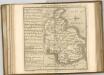

![Buckingamiae Comitatus cum Bedfordiensi; vulgo Buckingamshire and Bedfordshire. [Karte], in: Novus atlas absolutissimus, Bd. 7, S. 239.](https://images-2.georeferencer.com/images/iiif/664973570441/full/,300/0/native.jpg)

