Maps of Lolland Municipality

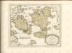
Lalandiae et Falstriae Accurata Descriptio. [Karte], in: Novus atlas absolutissimus, Bd. 1, S. 128.
1 Karte aus Atlas Janssonius Offizin
LALANDIA, | FALSTRIA | et | MONA | INSVLÆ | IN MARI BALTHICO.
Joannes Blaeu Excudit.
Korsör 12, uit: Special-Karte von Mittel-Europa / nach amtlichen Quellen bearbeitet von W. Liebenow
1 : 300000 titelvariant: W. Liebenow's Mittel-Europa; Annotatie: Titel boven de bladen: W. Liebenow's Mittel-Europa Johannes Wilhelm Liebenow 1822-1897 Frankfurt a. M. : Ludwig Ravenstein
Composite: 40. Wester-Markelsdorf. (Germany)
1 : 100000 Reichsamt fur Landesaufnahme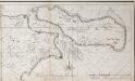
De Groenen Sond int groot in de Belt tussen Meun en Falster
Denmark Johannes van Keulen
11. Wester-Markelsdorf, uit: Topographische Uebersichtskarte des Deutschen Reiches / herausgegeben v. d. Kartogr. Abt. d. Königl. Preuß. Landesaufnahme
1 : 200000 titelvariant: Topogr. Übersichtskarte des Deutschen Reiches; Annotatie: Titel boven bladen ook: Topogr. Übersichtskarte des Deutschen Reiches; Annotatie geografische gegevens: Op elk blad twee maatstokken: 10 Kilometer = 5,5 cm; 1 geogr. Meile = 3,6 cm; Legenda onder op elk blad Königlich Preußische Landesaufnahme. Kartographische Abtheilung [S.l : Königlich Preußische Landesaufnahme, Kartographische Abtheilung]
40. Wester-Markelsdorf. (Germany)
1 : 100000 Reichsamt fur Landesaufnahme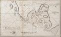
Het Gat van Naskou of Maschou int groot aen de Westkust van Laland in de Belt
Denmark Johannes van Keulen
Meßtischblatt 256, neue Nr. 1433 : Krummensiek (Insel Fehmarn), 1937
1 : 250000 Krummensiek (Insel Fehmarn). - Hrsg. 1879. - 1:25000. - [Berlin]: Reichsamt für Landesaufnahme, 1937. - 1 Kt.
Meßtischblatt 255 : Westermarkelsdorf, 1908
1 : 250000 Westermarkelsdorf (Insel Fehmarn). - Aufn. 1906 ?, hrsg. 1908. - 1:25000. - [Berlin]: Reichsamt für Landesaufnahme, 1908. - 1 Kt.
Sect. 2: Stralsund, uit: Geologische Karte des Deutschen Reichs in 27 Blaettern / [von] Richard Lepsius ; Red. von C. Vogel
1 : 500000 Annotatie: Blad 18 ontbreekt; Een aantal bladen op linnen; Een aantal bladen gereviseerd 1913-1914; Annotatie geografische gegevens: Met schaalstokken o.a. in kilometers; Legenda Carl Vogel 1828-1897 Gotha : Justus Perthes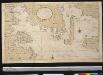
Een gedeelte van de Beldt Zee vertoonende desselfs Westelijkste zeekusten int grood bestek
Denmark Gerard van Keulen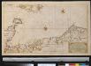
Nieuwe afteekening van een gedeelte van de Belt Zee vervattende de zeekusten van Holsteijn en Mekelenburg van het eijlant Femeren tot aan Mardorp in Pomeren
Germany Johannes van Keulen
Rostock 22, uit: Special-Karte von Mittel-Europa / nach amtlichen Quellen bearbeitet von W. Liebenow
1 : 300000 titelvariant: W. Liebenow's Mittel-Europa; Annotatie: Titel boven de bladen: W. Liebenow's Mittel-Europa Johannes Wilhelm Liebenow 1822-1897 Frankfurt a. M. : Ludwig Ravenstein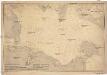
Ostsee
1 : 100000 Dánsko Reichs-Marine-Amt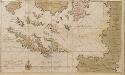
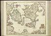
Dese eijlanden leggen aen de zuijtkand vant eijland Fuijnen in de Belt of Oostzee
Denmark Gerard van Keulen
Insvlae Danicae in Mari Balthico sitae utpote Zeelandia, Fionia, Langelandia, Lalandia, Falstria, Fembria Mona repraesentatae
1 : 470000 Baltské moře-oblast Homann, Johann Baptist J.B. Homann
Insvlae Danicae in mari Balthico sitae utpote Zeelandia, Fionia, Langelandia, Lalandia, Falstria, Fembria Mona
1 : 470000 Baltské moře-oblast Homann, Johann Baptist a Ioh. Bapt. Homanno
[67][67] Insularum Danicarum ...., uit: Atlas sive Descriptio terrarum orbis
Annotatie: Gedigitaliseerde versie. Amsterdam. Heiloo : Picturae (vervaardiger), 2015. tiff-bestand. Gedigitaliseerd: 07-01-2015; Origineel: Universiteitsbibliotheek Vrije Universiteit (XL.05127.-) ; Netherlands; Titelpagina ontbreekt Wit, Frederik de Amsterdam : Frederick de Wit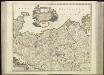
[44][44] Ducatus Meklenburgicus ..., uit: Atlas sive Descriptio terrarum orbis
Annotatie: Gedigitaliseerde versie. Amsterdam. Heiloo : Picturae (vervaardiger), 2015. tiff-bestand. Gedigitaliseerd: 07-01-2015; Origineel: Universiteitsbibliotheek Vrije Universiteit (XL.05127.-) ; Netherlands; Titelpagina ontbreekt Wit, Frederik de Amsterdam : Frederick de Wit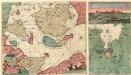
Nieuwe Pascaert van de Sond ende Beldt :
1 : 470000 Mollova mapová sbírka Keulen, Johannes van Keulen, Johannes van II
Kongeriget Danmark
1 : 500000 Bornholm (Dánsko) Generalstabens topografiske afdeling
Kongeriget Danmark
1 : 500000 Bornholm (Dánsko) Generalstabens topografiske afdeling
Denmark.
1 : 630000 Pinkerton, John, 1758-1826
Denmark.
1 : 1800000 Arrowsmith, Aaron; Lewis, Samuel
Denmark.
1 : 1800000 Arrowsmith, Aaron; Lewis, Samuel
Denmark.
1 : 1020000 Hall, S. (Sidney)
![Lalandiae et Falstriae Accurata Descriptio. [Karte], in: Novus atlas absolutissimus, Bd. 1, S. 128.](https://images-2.georeferencer.com/images/iiif/956815835518/full/,300/0/native.jpg)

