Maps of Switzerland

Helvetia, cum finitimis regionibus confoederatis. [Karte], in: Novus Atlas, das ist, Weltbeschreibung, Bd. 1, S. 245.
1 Karte aus Atlas Blaeu, Joan Blaeu, Willem Janszoon
Helvetia, cum finitimis regionibus confoederatis. [Karte], in: Le théâtre du monde, ou, Nouvel atlas contenant les chartes et descriptions de tous les païs de la terre, Bd. 1, S. 276.
1 Karte aus Atlas Blaeu, Willem Janszoon und Blaeu, Joan Blaeu, Willem Janszoon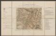
Helvetia cum finitimis regionibus confoederatis. [Karte], in: Gerardi Mercatoris et I. Hondii Newer Atlas, oder, Grosses Weltbuch, Bd. 1, S. 256.
1 Karte aus Atlas Mercator, Gerhard und Hondius, Jodocus Jansson, Jan
Helvetiae Tredecim Statibvs Liberis qvos Cantones vocant, composita Una cum foederatis & subjectis Provinciis, ex probatissimis Subsidiis geographice
1 : 680000 Mollova mapová sbírka Mayer, Tobias Homann, Johann Baptista - dědici
Reisekarte der Schweiz
Vorderseite: Karte mit fünf Nebenkarten. Rückseite: Titelblatt mit Erklärung der Zeichen und Höhenangaben einiger Seen. Zeichnung: Keller, Heinrich (1778-1862), Kartograf, Panoramenzeichner und Verleger, von Zürich Stich: Scheuermann, Johann Jakob, andere Schreibweise: Scheurmann, (1771-1844), Kupferstecher, von Zofingen AG

Helvetia, cum finitimis regionibus confoederatis. [Karte], in: Theatrum orbis terrarum, sive, Atlas novus, Bd. 1, S. 291.
1 Karte aus Atlas Blaeu, Joan Blaeu, Willem Janszoon
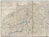
Zweite Keller'sche Reisekarte der Schweiz
Vorderseite: Überarbeitete und ergänzte Ausgabe der ersten Auflage von 1833. Mit einer Nebenkarte der Region Vintschgau/Tirol sowie vier Nebenkarten der Routen aus der Schweiz nach Paris, Würtemberg, Bayern, Tirol, Lyon, Chambery, Mailand, Genua und Turin. Rückseite: Kommentar von Heinrich Keller zur Karte, Übersicht über weitere von Keller gezeichnete und herausgegebene Karten sowie Übersichtsblatt einer anderen Karte. Keller, Heinrich (1778-1862), Kartograf, Panoramenzeichner und Verleger, von Zürich
Switzerland.
1 : 450000 Lucas, Fielding Jr.
Carte pour l'histoire ancienne de l'Helvétie
1 Karte auf 4 Bl. [Charles Guillaume Loys de Bochat] ; [Jean Philippe Loys de Cheseaux] chés Bousquet, Lausanne
Suisse.
1 : 1270000 Malte-Brun, Conrad, 1775-1826
Novissima et accuratissima Helvetiae, Rhaetiae, Valesiae, et partis Sabaudiae tabula.
Amsterdam : ex officina R. & J. Ottens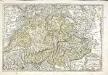
Les Suisses, les alliés des Suisses et leurs suiets
1 Karte : Kupferdruck ; 36 x 53 cm Sanson; Cordier Nicolas Sanson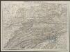
Helvetia cum finitimis regionibus confoederatis. [Karte], in: Gerardi Mercatoris Atlas, sive, Cosmographicae meditationes de fabrica mundi et fabricati figura, S. 261.
1 Karte aus Atlas Mercator, Gerhard Montanus, Petrus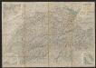
Roadmap of Switzerland
1 : 355000 Müllhaupt, Hans Heinrich ; Bressanini, Rinaldo ; Leuthold, Hans Felix Leuthold
<<La>> Suisse divisée en ses cantons, ses alliés et sujets et distinguée en pays catholiques, protestans et mixtes
1 : 1250000 1 Karte par [Louis] Brion chez Desnos, Rue St-Jacques au Globe, Paris
Nova Helvetiae, foederatarumque cum ea, nec non subditarum regionum tabula, ad usum serenissimi Burgundiae ducis, secundum commentarios domini Merveilleux
1 Karte composita per Guilielmum de l'Isle apud Joh. Covens & Corn. Mortier, Amstelodami
Nova Helvetiae tabula geographica illustrissimis et potentissimis cantonibus et rebuspublicis reformatae religionis Tigurinae, Bernensi, Glaronensi, Basiliensi, Scaphusianae, Abbatis Cellanae
1 : 230000 1 Karte auf 4 Bl. dominis suis clementissimis humillime dicata a Ioh. Iacobo Scheuchzero Tigurino, 1712 ; Ioh. Melch. Füsslin ornamenta pinx. ; Ioh. Henr. Huber et Eman. Schalch sculps. [Hofmeister], [Zürich]
Charte von der Republik Schweiz
Neuester Schul-Atlas Walch, Johann im Verlag bei Joh. Walch
Switzerland
1 : 750000 Topogr. Anst. v. Wurster, Randegger
Die Schweiz
Stieler's Hand-Atlas Stieler, Adolf bei Justus Perthes
Geographisches Verzeichniss der merkwürdigsten Orte in der Schweiz
1 : 700000 1 Karte Hein. Körner delin. ; J. Rodolf Holzhalb sculps. [Verlag nicht ermittelbar], [Zürich]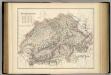
Switzerland.
1 : 696960 Fullarton, A. & Co.
Homannův atlas světa
1 : 7000000
Carte de Suisse
1 Karte dressée sur les mémoires de Merveilleux par Guillaume De l'Isle ; augmenté en 1759 par Phil. Buache chez l'auteur sur le Quay de l'Horloge, Paris
Colton's Switzerland
1 : 970000 1 Karte [by J.H. Colton & Co.] ; published by Johnson & Browning Johnson & Browning, 172 William St., New York
Petite carte de la Suisse pour les écoles
1 : 800000 1 Karte gezeichnet und herausgegeben von H. Keller Heinrich Keller, untere Zäune No. 367, Zürich
Karte der Schweiz
1 : 400000 Leuzinger, Rudolf J. Dalp (C. Schmid)
![Helvetia, cum finitimis regionibus confoederatis. [Karte], in: Novus Atlas, das ist, Weltbeschreibung, Bd. 1, S. 245.](https://images-2.georeferencer.com/images/iiif/662273486289/full/,300/0/native.jpg)

