Maps of Iran
Tabula Asiae IIII. [Karte], in: Claud. Ptolemaeus. Geographia lat. cum mappis [...], S. 305.
1 Karte aus Atlas Münster, Sebastian [und Ptolemaeus, Claudius]
Tableau historique des Empires d'Assyrie, de Babylone.
1 : 23500000 Duval, Henri
Asia Minor, Persia.
1 : 10000000 Andree, Richard; Times (London, England)
Middle East. Pergamon World Atlas.
1 : 5000000 Polish Army Topography Service
Tabula Asiae IIII. [Karte], in: Geographia universalis vetus et nova complectens Claudii Ptolemaei Alexandrini enarrationis libros VIII, S. 275.
1 Karte aus Atlas Münster, Sebastian [und Ptolemaeus, Claudius]
Greece, Turkey, Persia, India.
Cornell, S. S. (Sarah S.)
Vorderasien, Persien.
1 : 10000000 Andree, Richard
Turquia asiàtica / Ramon Alabern lo grabó
1 mapa. Datat al 1850 aproximadament. Alaber, Ramon
Regna Lydium, Medicum, Babylonium etc.
Mesopotamien Antike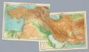
Composite: Near East.
1 : 4000000 John Bartholomew and Son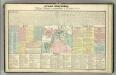
Tableau historique de l'Histore Sacree.
1 : 13800000 Duval, Henri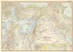
Lands of the bible today
Mappa dispersus filiorum Noemi
1 : 10670000 Malá Asie Bonne, Rigobert André
[Das Mittelländische Meer und Nord-Afrika]
Handatlas über alle Theile der Erde und über das Weltgebäude Stieler, Adolf Justus Perthes
Asia occidental I
1 mapa. Datat al s.XIX. 0 Gras y compañia, editores. Madrid
Říše turecká
1 : 5000000 Asie jihozápadní V. Neubert
[Das Mittelländische Meer und Nord-Afrika, Östliches Blatt]
Hand-Atlas über alle Theile der Erde und über das Weltgebäude Stieler, Adolf Justus Perthes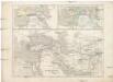
Vorderasien 600 v. Ch
Asie západní
Afbeeldinge der Oostersche landen waar in, zoo de X stammen Israëls, als de II overige van Juda; gedurende den tyd hunner ballingschap verkeert hebben : tot opheldering van dit gedeelte der gewyde geschiedenis
1 : 6000000 ontworpen door W.A. Bachiene J. van Jagen mapp. sculpsit, et figur. apposit. sculpturam curavit ; S. Fokke fec. Uitgegeven te Gorinchem : by Nicolaas Goetzee
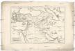
L'Empire des Perses.
1 : 13000000 Houze, Antoine Philippe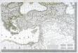
Carte d'Europe ou sont tracées les limites des empires, royaumes, et etats souverains, feuille 6
1 Blatt : 63 x 93 cm Semen etc
[Recto], uit: Midden-Oosten (Nabije-Oosten) / [aardrijksk. medew. G.J. de Vries]
1 : 13700000 Annotatie: Verso: namen van de landen van het Midden-oosten met aanduiding van de oppervlakte en het aantal inwoners,de hoofdsteden met vermelding van het het aantal inwoners, en informatie over het Suezkanaal; Annotatie geografische gegevens: Inzet: Suez Kanaal Gerben Johannes de Vries 1886-1968 Sneek : Tonnema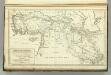
Countries Situated between Shiraz and Constantinople.
1 : 6000000 Melish, John
Turcia Asiatica : exhibens Natoliam modernam, in suos beglirbegatus divisam, itemque reliquos beglirbegatus, sive gubernationes et Prœfecturas generales, in regionibus Georgiæ, Armeniæ, Mespotamiæ, Syriæ et Arabiæ sitos, una cum Mari Nigro, Mari Azowiensi, Mari di Marmora, et Mari Ægeo, atque adiacentibus Insulis : C. P. S. C. M. = Carte de la Turquie asiatique contenant la Natolie moderne divisée en les beglerbeys &
1 : 4800000 Homann Erben (Firm) Homannianorum Heredum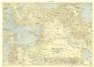
Bible Lands and the cradle of western civilization
1 : 3000000 Jeruzalém National Geographic Society
Asie Anterieure.
1 : 5000000 Vivien St Martin, L.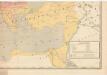
Evropa raného středověku: do konce VI. století po Kr.
Kašpar, Jan
Imperium Turcicum
Turecko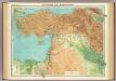
Asia Minor, Syria & Mesopotamia.
1 : 4000000 John Bartholomew and Son
![Tabula Asiae IIII. [Karte], in: Claud. Ptolemaeus. Geographia lat. cum mappis [...], S. 305.](https://images-2.georeferencer.com/images/iiif/239207806063/full/,300/0/native.jpg)

