Maps of Bavaria

Le Cercle De Baviere. subdivisé en tous les Estats qui le Composent [Karte], in: Atlas nouveau, contenant toutes les parties du monde [...], Bd. 1, S. 264.
1 Karte aus Atlas Sanson, Nicolas Jaillot, Alexis Hubert und Mortier, Pieter
Le cercle de Baviere
1 Karte auf 2 Blatt : Kupferdruck ; 80 x 54 cm Sanson; Jaillot chez H. Iaillot joignant les grands Augustins aux deux globes
Le cercle de Baviere
1 Karte : Kupferdruck ; 64 x 44 cm Sanson; Jaillot; Cordier chez le Sr. Iaillot geographe de Sa Maj.té joignant les gr. Augustins aux 2. globes
[Atlas zur Geschichte von Bayern] : VII. Das Königreich Bayern nach seinen gegenwärtigen Bestandtheilen mit allen Gebiets-Veränderungen von 1801 bis 1816
K. v. Spruner W. Hase sc. Weimar [Gotha : Perthes]
[Atlas zur Geschichte von Bayern] : IV. Die Herzogthümer Baiern, Franken, und ein Theil von Alemannien im XII & XIII Jahrhundert nach erblichen Grafschaften & Gebieten getheilt
K. v. Spruner [Gotha : Perthes]
CHARTE vom KÖNIGREICHE BAYERN
Bavorsko (Německo)
Charte vom Königreiche Bayern
Bavorsko (Německo)
CHARTE vom KÖNIGREICHE BAYERN
Bavorsko (Německo)
[Atlas zur Geschichte von Bayern] : II. Die Gauen von Bojoaria, Franconia, und eines Theils von Alemannia vom VIIIten bis in’s XIte Jahrhundert
K. v. Spruner [Gotha : Perthes]
Charte vom Königreiche Bayern
1 : 1040000 Bavorsko (Německo) Güssefeld, Franz L. Ehnlich, I. F. C. im Verlag des Geograph. Instituts
Boioaria aetate romanorvm collata cvm hodierna
1 Karte : Kupferdruck ; 24 x 29 cm Braun; Zimmermann Ruprecht
Le cercle de Baviere, subdivisé en touts les estats qui le composent
1 : 600000 Bavorsko (Německo) Sanson, Guillaume Jaillot, Alexis-Hubert H. Iaillot
Königreich Bayern
1 : 1284000 Bavorsko (Německo) Tranquillo Mollo
Le cercle de Baviere
1 Karte : Kupferdruck ; 59 x 44 cm Jaillot; Ottens; Ottens chez R. et J. Ottens
Le cercle de Baviere
1 Karte : Kupferdruck ; 59 x 44 cm Drogenham; Jaillot chez H. Jaillot
Novissima et Accuratissima Delineatio Geographica Superioris et inferioris Ducatus Bavariae Vnacum adjecentium Provinciarum Limitibus
1 : 750000 Mollova mapová sbírka Sedelmayer, Johann Paul Sedlmayr, Johann Paul
Karte vom Koenigreich Baiern in Kreise eingetheilt
Bavorsko (Německo) Klipstein, A. Walch, Johann bei Joh. Walch
Teutschlandes Bayerischer Creiss samt dazu gehörigen Provintzen
1 : 2500000 Mollova mapová sbírka Weigel, Johann Christoph Weigel, Christoph I.
Bavaria.
1 : 1650000 Bowen, Frances
Le Cercle de Baviere subdivisé en tous les Estats qui le composent
1 : 735000 Mollova mapová sbírka Sanson, Nicolas Jaillot, Alexis Hubert
Le Cercle de Baviere
1 : 585000 Mollova mapová sbírka Sanson, Guillaume Jaillot, Alexis Hubert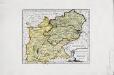
Das Herzogthum Ober und Nieder Bayern
1 Karte : Kupferdruck ; 22 x 27 cm Reilly F. J. J. von Reilly
Königreich Bayern
1 : 1240000 Bavorsko (Německo) Mollo, Tranquillo bey Tranquillo Mollo
Les cercles de Souabe et de Baviere
1 : 1740000 Bavorsko (Německo) Bonne, Rigobert André
Le Cercle de Baviere divisè en tous les Estats qui le Composent a L'Usage de Monseigneur le duc de Bourgogne
1 : 740000 Mollova mapová sbírka Jaillot, Alexis-Hubert Ottens, Josua
Charte vom Königreiche Bayern
Bavorsko (Německo) Streit, Friedrich Wilhelm
Karte vom Königreich Baiern
1 : 1100000 Bavorsko (Německo) in A.G. Schneider u. Weigels k. priv. Kunst- u. Landkartenhandlung
Germany south of the Mayn.
1 : 885000 Pinkerton, John, 1758-1826
Das Königreich Baiern
1 : 780000 Bavorsko (Německo) Dirwald, Joseph Mannert, Conrad T. Mollo
Königreich Baiern nach der neuesten Begrenzung
1 : 700000 Bavorsko (Německo) Mollo, Tranquillo T. Mollo
![Le Cercle De Baviere. subdivisé en tous les Estats qui le Composent [Karte], in: Atlas nouveau, contenant toutes les parties du monde [...], Bd. 1, S. 264.](https://images-2.georeferencer.com/images/iiif/684120512935/full/,300/0/native.jpg)

