Maps of Bavaria

[Atlas zur Geschichte von Bayern] : II. Die Gauen von Bojoaria, Franconia, und eines Theils von Alemannia vom VIIIten bis in’s XIte Jahrhundert
K. v. Spruner [Gotha : Perthes]
[Atlas zur Geschichte von Bayern] : IV. Die Herzogthümer Baiern, Franken, und ein Theil von Alemannien im XII & XIII Jahrhundert nach erblichen Grafschaften & Gebieten getheilt
K. v. Spruner [Gotha : Perthes]
[Atlas zur Geschichte von Bayern] : VII. Das Königreich Bayern nach seinen gegenwärtigen Bestandtheilen mit allen Gebiets-Veränderungen von 1801 bis 1816
K. v. Spruner W. Hase sc. Weimar [Gotha : Perthes]
Charte vom Königreiche Bayern
1 : 1040000 Bavorsko (Německo) Güssefeld, Franz L. Ehnlich, I. F. C. im Verlag des Geograph. Instituts
CHARTE vom KÖNIGREICHE BAYERN
Bavorsko (Německo)
Charte vom Königreiche Bayern
Bavorsko (Německo)
Karte vom Koenigreich Baiern in Kreise eingetheilt
Bavorsko (Německo) Klipstein, A. Walch, Johann bei Joh. Walch
Charte vom Königreiche Bayern
Bavorsko (Německo) Streit, Friedrich Wilhelm
Das Königreich Baiern
1 : 780000 Bavorsko (Německo) Dirwald, Joseph Mannert, Conrad T. Mollo
[Atlas zur Geschichte von Bayern] : VIa. Bayern und die obere Pfalz, mit ihren Theilungen, Erwerbungen und Verlusten, vom XIII bis ins XVI Jahrhundert. VIb. Bayern, Pfalz und Zweybrücken nebst den niederrheinischen Herzogthümern im Jahre 1778
K. v. Spruner Gest. b. Mädel II [Gotha : Perthes]
Das Königreich Baiern
Allgemeiner Atlas [Walch, Johannes] im Verlag bei Johannes Walch
Das Königreich Baiern nach Mannert und andern vorzüglichen Hülfsmitteln
1 : 690000 Bavorsko (Německo) Dirwald, Joseph Mannert, Conrad T. Mollo
CHARTE vom KÖNIGREICHE BAYERN
Bavorsko (Německo)
Königreich Baiern nach der neuesten Begrenzung
1 : 700000 Bavorsko (Německo) Mollo, Tranquillo T. Mollo
Königreich Baiern nach der neuesten Begrenzung
1 : 700000 Bavorsko (Německo) Mollo, Tranquillo T. Mollo

[Atlas zur Geschichte von Bayern] : I. Rhaetia, Noricum und die angränzenden Länder
K. v. Spruner [Gotha : Perthes]
Königreich Bayern
1 : 1284000 Bavorsko (Německo) Tranquillo Mollo
Karte von Baiern und Schwaben mit einem grossen Theil von Böhmen, Österreich, Salzburg, Steyermark, Kärnten und Krein
Bavorsko (Německo) Artaria
Königreich Bayern
1 : 1240000 Bavorsko (Německo) Mollo, Tranquillo bey Tranquillo Mollo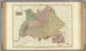
Germany south of the Mayn.
1 : 885000 Pinkerton, John, 1758-1826
Souabe, Baviere.
1 : 2900000 Clouet, J. B. L. (Jean-Baptiste Louis), b. 1730
Neueste Karte von Bayern, Tirol mit dem grösten Theil von Schwaben und angränzenden österreichischen Provinzen
1 : 790000 Bavorsko (Německo) Sotzmann, Daniel Friedrich Artaria
Chur-Bayern im Jahr 1804
1 : 1083000 Bavorsko (Německo) Herdegen, J. C. F. Leizel, Balthasar Friedrich J.L.C. Rheinwald
Raetiae veteris exterae et hodiernae una cum regionibus ei guondam [i.e. quondam] adnumeratis & finitimarum regionum limitibus tabula generalis
1 : 1100000 1 Karte Matth. Hirtzg. ; Leo. Scherer [Joh. Rodolff Wolffen], [Zürich]
Karte vom Königreich Baiern
1 : 1100000 Bavorsko (Německo) in A.G. Schneider u. Weigels k. priv. Kunst- u. Landkartenhandlung
Suevia Et Bavaria XI. Nova Tabula. [Karte], in: Geographia universalis vetus et nova complectens Claudii Ptolemaei Alexandrini enarrationis libros VIII, S. 329.
1 Karte aus Atlas Münster, Sebastian [und Ptolemaeus, Claudius]
Salisbvrgensis Ivrisdictionis, locorumque vicinorum vera descriptio
1 : 730000 Mollova mapová sbírka Setznagel, Marx Rade, Gillis van den
Les cercles de Souabe et de Baviere
1 : 1740000 Bavorsko (Německo) Bonne, Rigobert André
Postkarte von dem Bayrischen und Schwaebischen Kreise
Bavorsko (Německo) Müller, Franz Deilly'schen Lankarten und Kunstwerke Verschleiss Komtoir
![[Atlas zur Geschichte von Bayern] : II. Die Gauen von Bojoaria, Franconia, und eines Theils von Alemannia vom VIIIten bis in’s XIte Jahrhundert](https://images-2.georeferencer.com/images/iiif/403370898590/full/,300/0/native.jpg)

