Maps of Bavaria


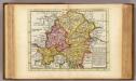
Potentia Archiducum Austriae sive circuli Austriaci delineatio
1 : 1550000 Evropa střední Lotter, Tobias Conrad T. C. Lotter
Potentia archiducum Austriae sive circuli Austriaci delineatio, qua illius fines hodierni graphice et accurate exhibentur
1 : 1550000 Evropa střední Lotter, Tobias Conrad impensis Tob. Conradi Lotteri
Potentia archiducum Austriae sive circuli Austriaci delineatio
1 : 1550000 Evropa střední Lotter, Tobias Conrad studio et impensis Tob. Conradi Lotteri
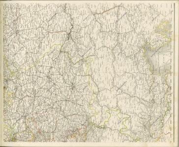
Germania Austriaca completens s. r. i. circulum Austriacum ut et reliquas in Germania augustissimae domui Austr. devotas terras haereditarias
1 : 710000 Evropa střední Homann, Johann Baptist J. B. Homann
[Atlas zur Geschichte von Bayern] : VIa. Bayern und die obere Pfalz, mit ihren Theilungen, Erwerbungen und Verlusten, vom XIII bis ins XVI Jahrhundert. VIb. Bayern, Pfalz und Zweybrücken nebst den niederrheinischen Herzogthümern im Jahre 1778
K. v. Spruner Gest. b. Mädel II [Gotha : Perthes]
Nieuwe kaart van de Beyersche en Oostenryksche Kreits
1 : 2000000 Annotatie: Uit: Nieuwe Hand-Atlas. - Amsterdam : Tirion, 1744 Te Amsterdam : by Isaak Tirion
Germania Austriaca complectens S. R. I. Circulum Austriacum ut et reliquas in Germania Augustissimae Domui Austr. devotas Terras Haereditarias
1 : 1440000 Mollova mapová sbírka Homann, Johann Baptist Homann, Johann Baptista
Leopoldi Magni filio Iosepho I. Avgvsto Romanorvm et Hvng. regi ad capessendum Rhenanae militiae imperium in castra proficiscenti hanc Germaniae Avstriacae generalem tabvlam
1 : 1430000 Evropa střední Homann, Johann Baptist Io. Bapt. Homann
Maiestas Austriaca sive Circul. Archi Ducat.-Austriae :
1 : 1450000 Mollova mapová sbírka Seutter, Matthäus
Maiestas Austriaca sive Circ. Archi Ducat. Austriae
1 : 3400000 Mollova mapová sbírka Seutter, Matthäus Lotter, Tobias Conrad
Deutsch-Oesterreichische Länder
1 : 5000000 Österreich
Maiestas Austriaca sive circul. archiducat. Austriae cum ceteris augustissimae huic domui per Germaniam continuo ferme tractu devotis haereditariis terris ob oculos profit
1 : 1450000 Evropa střední Seutter, Matthäus Probst, Johann Michael Ioh. Mich. Probst
Maiestas Austriaca sive circul[us] archiducat[us] Austriae
1 : 1450000 Evropa střední Seutter, Matthäus per Matthaeum Seutterum
Maiestas Austriaca sive circul[us] archiducat[us] Austriae
1 : 1450000 Evropa střední Seutter, Matthäus per Matthaeum Seutterum
Germaniae Avstriacae Tabula Generalis
1 : 2100000 Mollova mapová sbírka Weigel, Christoph Kauffer, Michael Weigel, Christoph I.
S. R. I. Circvlvs Avstriacvs
1 : 1800000 Mollova mapová sbírka Mayer, Tobias Homann, Johann Baptista - dědici

Mapa Rakouska
1 : 2000000
Das Königreich Baiern
Allgemeiner Atlas [Walch, Johannes] im Verlag bei Johannes Walch

Der Oesterreichische Kreis
1 : 1380000 Evropa střední Güssefeld, Franz L. Liesganig, Joseph bey den Homannischen Erben
Maiestas Austriaca sive circ. archiducat. Austriae
1 : 3400000 Evropa střední Seutter, Matthäus Lotter, Tobias Conrad Tobias Conrad Lotter
The South East Part of Germany
1 : 3500000 Mollova mapová sbírka Moll, Herman Moll, Hermann
Sbírka map a diagramů použitých na mírových konferencích v Paříži v letech 1919 - 1920

Karte von Baiern und Schwaben mit einem grossen Theil von Böhmen, Österreich, Salzburg, Steyermark, Kärnten und Krein
Bavorsko (Německo) Artaria
[Rakousko]
1 : 2115000 Evropa střední
Süd-Östliches Deutschland, enthält die Oesterreichischen Lande
Schul-Atlas über alle Theile der Erde nach dem neuesten Zustande, und über das Weltgebäude Stieler, Adolf bei Justus Perthes
Autriche
1 : 1000000 Rakousko Čs. voj. zeměp. ústav