Maps of Bavaria

Le Cercle de Baviere subdivisé en tous les Estats qui le composent
1 : 735000 Mollova mapová sbírka Sanson, Nicolas Jaillot, Alexis Hubert
Le Cercle de Baviere
1 : 585000 Mollova mapová sbírka Sanson, Guillaume Jaillot, Alexis Hubert
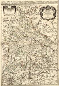
Le Cercle de Baviere divisè en tous les Estats qui le Composent a L'Usage de Monseigneur le duc de Bourgogne
1 : 740000 Mollova mapová sbírka Jaillot, Alexis-Hubert Ottens, Josua
Novissima et Accuratissima Delineatio Geographica Superioris et inferioris Ducatus Bavariae Vnacum adjecentium Provinciarum Limitibus
1 : 750000 Mollova mapová sbírka Sedelmayer, Johann Paul Sedlmayr, Johann Paul
Le cercle de Baviere
1 Karte auf 2 Blatt : Kupferdruck ; 80 x 54 cm Sanson; Jaillot chez H. Iaillot joignant les grands Augustins aux deux globes
Le cercle de Baviere
1 Karte : Kupferdruck ; 64 x 44 cm Sanson; Jaillot; Cordier chez le Sr. Iaillot geographe de Sa Maj.té joignant les gr. Augustins aux 2. globes
Le Cercle De Baviere. subdivisé en tous les Estats qui le Composent [Karte], in: Atlas nouveau, contenant toutes les parties du monde [...], Bd. 1, S. 264.
1 Karte aus Atlas Sanson, Nicolas Jaillot, Alexis Hubert und Mortier, Pieter
Le cercle de Baviere, subdivisé en touts les estats qui le composent
1 : 600000 Bavorsko (Německo) Sanson, Guillaume Jaillot, Alexis-Hubert H. Iaillot
Le cercle de Baviere Divisée en touts les estats qui le Composent &c.
1 : 575000 Mollova mapová sbírka Covens, Johannes I
Le cercle de Baviere
1 Karte : Kupferdruck ; 59 x 44 cm Jaillot; Ottens; Ottens chez R. et J. Ottens
Le cercle de Baviere
1 Karte : Kupferdruck ; 59 x 44 cm Drogenham; Jaillot chez H. Jaillot
Bavaria.
1 : 1650000 Bowen, Frances
Teutschlandes Bayerischer Creiss samt dazu gehörigen Provintzen
1 : 2500000 Mollova mapová sbírka Weigel, Johann Christoph Weigel, Christoph I.
Boioaria aetate romanorvm collata cvm hodierna
1 Karte : Kupferdruck ; 24 x 29 cm Braun; Zimmermann Ruprecht

CHARTE vom KÖNIGREICHE BAYERN
Bavorsko (Německo)
Karte vom Königreich Baiern
1 : 1100000 Bavorsko (Německo) in A.G. Schneider u. Weigels k. priv. Kunst- u. Landkartenhandlung
Königreich Bayern
1 : 1284000 Bavorsko (Německo) Tranquillo Mollo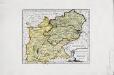
Das Herzogthum Ober und Nieder Bayern
1 Karte : Kupferdruck ; 22 x 27 cm Reilly F. J. J. von Reilly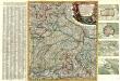
Neue und vollständige Land-Karten Des gantzen Chür-Baÿrischen Reichs Creÿses in specie Das Hertzogthüm Baÿern, die Obere Pfaltz, das Ertz-Stifft Saltzbürg, die Büsthümer Freising und Passaü wie äuch einen mercklichen Theil des daran stoßenden Franckens, Böhmens ünd Ober Oesterreichs vorstellend in dere[n] noch flienere inländische Gräntzen, Stationen deren Posten ünd anderen Nothwendigkeite aüf das genaüeste eingetheilet aüch mit großer Mühe und Fleiß an das Licht gebracht
1 : 650000 Mollova mapová sbírka Lidl, Johann Jakob Lidl, Johann Jacob
Circulus Bavaricus
1 Karte : Kupferdruck ; 49 x 57 cm Danckerts Danckerts
Circulus Bavaricus
1 : 720000 1 Karte : Kupferdruck ; 48 x 57 cm Danckerts, Justus [Danckerts]
Imperii circulus Bavaria, titulô electoratus insignis ea pro ut in ducatum, ac palatinatum, alisques eorundem status hic politice divisa
1 : 630000 Bavorsko (Německo) Carmine, Joseph apud Ioseph Carmine
Circulus Bavaricus oder Geographische Grundlegung des Bairischen Craisses
1 : 580000 Bavorsko (Německo) Lotter, Tobias Conrad Tobias Conrad Lotter
[Circulus Bavaricus oder Geographische Grundlegung des Bairischen Craisses]
1 : 580000 Bavorsko (Německo) Lotter, Tobias Conrad bey Tobias Conrad Lotter
Circulus Bavaricus oder Geographische Grundlegung des Bairischen Craisses sambt angraenzenden Laendern
1 : 580000 Bavorsko (Německo) Lotter, Tobias Conrad Tobias Conrad Lotter
Cours du Danube feuille II.e contenant la Baviere
1 Karte : Kupferdruck ; 54 x 49 cm, Bildgrösse 64 x 51 cm Homann; Le Rouge; Seutter chez le Sr. le Rouge ingen.r geographe du roy rue des Augustins vis a vis le panier fleuri
Circvlvs Bavaricvs
1 Karte : Kupferdruck ; 39 x 31 cm Weigel; Kauffer Christoph Weigel
Chur-Bairn Samt demselben incorporirten und angrenzenden Landen
1 : 730000 Mollova mapová sbírka Riegel, Christoph Riegel, Christoph