Maps of Switzerland
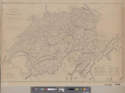
Carte physique et routière de la Suisse
1 : 760320 1 Karte by author of Switzerland illustrated [i.e. William Beattie] ; drawn & engraved by T. Starling George Virtue, Ivy Lane Paternoster Row, London
<<Les>> Suisses, leurs sujets et leurs alliéz
1 Karte corrigée et augmentée d'après les nouvelles observations de Ms. de l'Académie Royale des Sciences ; P. Starckman sculpsit chez Desnos, Rue St. Jacques au Globe, Paris
Carte de la république des Suisses, leurs sujets et alliées
1 Karte par J.E. Hauman chez Mondhare, Rue S.Jacques, Paris
Carte de la Suisse, ou l'on a marqué les routes suivies par Wil. Coxe dans ses quatre voyages en 1776, 1779, 1785 et 1786
1 : 450000 1 Karte Picquet direx.t. [chez Letellier, quai des Augustins No. 50], [Paris]
Karte der Schweiz
1 : 450000 1 Karte nach den neuesten Materialien entworfen und gezeichnet von Rudolf Gross ; gravirt: Terrain v. J. Graf, Schrift v. C. Spengler u. Rixinger Ch. Beyel, Frauenfeld
Carte des treize cantons Suisses, des alliés et des pays qui leurs sont sujetz
1 : 1250000 1 Karte [David-François de Merveilleux] [Harding], [London]
Roadmap of Switzerland
1 : 355000 1 Karte dressée et gravée par Mullhaupt ; écrit par Bressanini Leuthold, Zürich
Roadmap of Switzerland
1 : 400000 1 Karte dressée et gravée par Mullhaupt ; écrit par Bressanini ; publiée par H.F. Leuthold H.F. Leuthold, Zürich
Randegger's Reisekarte der Schweiz
1 : 600000 1 Karte [Kartogr.:] Topogr. Anstalt v. Wurster, Randegger & Co. in Winterthur J. Wurster & Co., Zürich
Helvetiae conterminarumque terrarum antiqua descriptio
1 : 1200000 1 Karte auctore Phil. Clüverio [Verlag nicht ermittelbar], [Wolfenbüttel]
Schweiz
1 : 700000 1 Karte Gaebler, Leipzig
Carte routière de la Suisse
1 : 570000 1 Karte par [Henri] Keller ; gravée par Pierre Tardieu Hipte. Souverain, Rue des Beaux-Arts 3bis, Paris
Carte des chemins de fer de la Suisse
1 : 300000 1 Karte par F. Müllhaupt ; avec la collab. de J. Ammann = Eisenbahn-Karte der Schweiz = Railway map of Switzerland = Carta delle strade-ferrate della Svizzera Müllhaupt, Bern
Roadmap of Switzerland
1 : 400000 1 Karte dressée et gravée par Mullhaupt ; écrit par Bressanini ; publiée par H.F. Leuthold H.F. Leuthold, Zürich
Carte industrielle de la Suisse pour l'année 1882
1 : 500000 1 Karte élaborée sur la demande du Comité Central de l'Exposition Nationale à Zurich par Hermann Schlatter = Industrie-Karte der Schweiz für das Jahr 1882 / im Auftrage des Central-Comite der schweiz. Landesausstellung in Zürich bearb. von Hermann Schlatter Wurster, Randegger & Co., Winterthur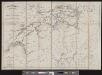
Eisenbahnkarte der Schweiz
1 : 500000 1 Karte gezeichnet von Rudolf Gross Schabelitz, Zürich
Relief-Karte der Schweiz
1 : 530000 1 Karte von R. Leuzinger ; [Kartogr.:] Topogr. Anstalt v. Wurster, Randegger & Co. in Winterthur J. Wurster & Co., Zürich
Schweiz
1 : 900000 1 Karte Fretz Frères S.A., Zurich
Schweiz
1 : 900000 1 Karte Gebr. Fretz AG, Zürich
Original von Keller's erster Reisekarte der Schweiz
1 : 500000 1 Karte Heinrich Keller, Zürich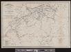
Eisenbahnkarte der Schweiz
1 : 500000 1 Karte gezeichnet von Rudolf Gross Verlag von Caesar Schmidt, Zürich
Carte industrielle de la Suisse pour l'année 1882
1 : 500000 1 Karte élaborée sur la demande du Comité Central de l'Exposition Nationale à Zurich par Hermann Schlatter = Industrie-Karte der Schweiz für das Jahr 1882 / im Auftrage des Central-Comite der schweiz. Landesausstellung in Zürich bearb. von Hermann Schlatter Wurster, Randegger & Co., Winterthur
Roadmap of Switzerland
1 : 400000 1 Karte dressée et gravée par Mullhaupt ; écrit par Bressanini ; publiée par H.F. Leuthold H.F. Leuthold, Zürich
Nouvelle carte physique & routière de la Suisse
1 : 800000 1 Karte par Keller H. Langlois Fils, Paris
Roadmap of Switzerland
1 : 400000 1 Karte dressée et gravée par Mullhaupt ; écrit par Bressanini ; publiée par H.F. Leuthold H.F. Leuthold, Zürich
Roadmap of Switzerland
1 : 400000 1 Karte dressée et gravée par Mullhaupt ; écrit par Bressanini ; publiée par H.F. Leuthold H.F. Leuthold, Zürich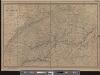
Carte physique et routière de la Suisse
1 : 490000 1 Karte publiée par J. Andriveau-Goujon J. Andriveau-Goujon, Paris
Schweiz
1 : 600000 1 Karte Wurster, Winterthur
Carte industrielle de la Suisse pour l'année 1882
1 : 500000 1 Karte élaborée sur la demande du Comité Central de l'Exposition Nationale à Zurich par Hermann Schlatter = Industrie-Karte der Schweiz für das Jahr 1882 / im Auftrage des Central-Comite der schweiz. Landesausstellung in Zürich bearb. von Hermann Schlatter Wurster, Randegger & Co., Winterthur