Maps of Switzerland

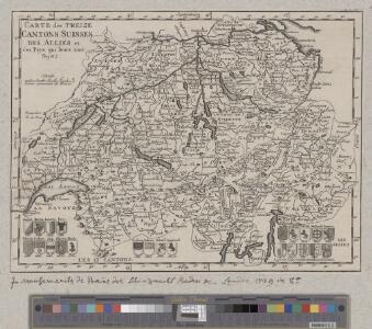
Carte des treize cantons Suisses, des alliés et des pays qui leurs sont sujetz
1 : 1250000 1 Karte [David-François de Merveilleux] [Harding], [London]
Roadmap of Switzerland
1 : 400000 1 Karte dressée et gravée par Mullhaupt ; écrit par Bressanini ; publiée par H.F. Leuthold H.F. Leuthold, Zürich
Roadmap of Switzerland
1 : 355000 1 Karte dressée et gravée par Mullhaupt ; écrit par Bressanini Leuthold, Zürich
Roadmap of Switzerland
1 : 400000 1 Karte dressée et gravée par Mullhaupt ; écrit par Bressanini ; publiée par H.F. Leuthold H.F. Leuthold, Zürich
Randegger's Reisekarte der Schweiz
1 : 600000 1 Karte [Kartogr.:] Topogr. Anstalt v. Wurster, Randegger & Co. in Winterthur J. Wurster & Co., Zürich
Roadmap of Switzerland
1 : 400000 1 Karte dressée et gravée par Mullhaupt ; écrit par Bressanini ; publiée par H.F. Leuthold H.F. Leuthold, Zürich
Roadmap of Switzerland
1 : 400000 1 Karte dressée et gravée par Mullhaupt ; écrit par Bressanini ; publiée par H.F. Leuthold H.F. Leuthold, Zürich
Randegger's Reisekarte der Schweiz
1 : 600000 1 Karte [Kartogr.:] Topogr. Anstalt v. Wurster, Randegger & Co. in Winterthur J. Wurster & Co., Zürich
Roadmap of Switzerland
1 : 400000 1 Karte dressée et gravée par Mullhaupt ; écrit par Bressanini ; publiée par H.F. Leuthold H.F. Leuthold, Zürich
Carte industrielle de la Suisse pour l'année 1882
1 : 500000 1 Karte élaborée sur la demande du Comité Central de l'Exposition Nationale à Zurich par Hermann Schlatter = Industrie-Karte der Schweiz für das Jahr 1882 / im Auftrage des Central-Comite der schweiz. Landesausstellung in Zürich bearb. von Hermann Schlatter Wurster, Randegger & Co., Winterthur
Hypsometrische Karte der Schweiz
1 : 380000 1 Karte auf 4 Blättern von J.M. Ziegler = Carte hypsométrique de la Suisse / par J.M. Ziegler Verlag von Joh. Wurster u. Comp., Winterthur
<<La>> Suisse
1 : 800000 1 Karte Keller, Zürich
Karte der schweizerischen Nationalrathswahlkreise
1 : 500000 1 Karte C. v. Hoven lith. Kümmerly, Bern
Karte der Schweiz für Schulen
1 : 750000 1 Karte R. Leuzinger Benziger & Co. A.G., Einsiedeln
Schweiz
1 : 700000 1 Karte Gaebler, Leipzig
Roadmap of Switzerland
1 : 400000 1 Karte dressée et gravée par Mullhaupt ; écrit par Bressanini ; publiée par H.F. Leuthold H.F. Leuthold, Zürich
Carte industrielle de la Suisse pour l'année 1882
1 : 500000 1 Karte élaborée sur la demande du Comité Central de l'Exposition Nationale à Zurich par Hermann Schlatter = Industrie-Karte der Schweiz für das Jahr 1882 / im Auftrage des Central-Comite der schweiz. Landesausstellung in Zürich bearb. von Hermann Schlatter Wurster, Randegger & Co., Winterthur
Carte routière de la Suisse
1 : 570000 1 Karte par [Henri] Keller ; gravée par Pierre Tardieu Hipte. Souverain, Rue des Beaux-Arts 3bis, Paris
Dritte Karte der Schweiz
1 : 380000 1 Karte von J.M. Ziegler J. Wurster & Co., Winterthur
Neue Karte der Schweiz
1 : 380000 1 Karte von J.M. Ziegler Topogr. Anstalt v. J. Wurster u. Comp., Winterthur
Relief-Karte der Schweiz
1 : 530000 1 Karte von R. Leuzinger ; [Kartogr.:] Topogr. Anstalt v. Wurster, Randegger & Co. in Winterthur J. Wurster & Co., Zürich
Carte physique et routière de la Suisse
1 : 760320 1 Karte by author of Switzerland illustrated [i.e. William Beattie] ; drawn & engraved by T. Starling George Virtue, Ivy Lane Paternoster Row, London
Dritte Karte der Schweiz
1 : 380000 1 Karte J.M. Ziegler J. Wurster & Co., Winterthur
Helvetia, Rhaetia, Valesia
1 Karte labore et studio Henrici Ludovici Muoss Muoss, [Zug]
Carte de la république des Suisses, leurs sujets et alliées
1 Karte par J.E. Hauman chez Mondhare, Rue S.Jacques, Paris
Carte physique et routière de la Suisse
1 : 490000 1 Karte publiée par J. Andriveau-Goujon J. Andriveau-Goujon, Paris
Carte industrielle de la Suisse pour l'année 1882
1 : 500000 1 Karte élaborée sur la demande du Comité Central de l'Exposition Nationale à Zurich par Hermann Schlatter = Industrie-Karte der Schweiz für das Jahr 1882 / im Auftrage des Central-Comite der schweiz. Landesausstellung in Zürich bearb. von Hermann Schlatter Wurster, Randegger & Co., Winterthur
<<La>> Suisse
1 : 800000 1 Karte Keller, Zürich
Eisenbahnen, Posten & Telegraphen-Karte der Schweiz
1 : 850000 1 Karte von F. Müllhaupt = Carte des chemins de fer, postes et télégraphes de la Suisse : toutes les stations et les nouveaux projets de chemin de fer sont indiqués clairement / par F. Müllhaupt Geographischer Verlag von H. Müllhaupt & Sohn, Bern