Maps of Kenosha

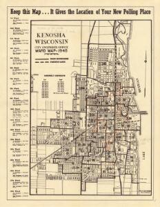
Kenosha, Wisconsin : ward map, 1948
1 : 17000 This map shows a list of polling places by ward and precinct in the left margin, a list of assembly districts, and additional handwritten notes. Lake Michigan is labeled as are streets and some points of interest. Some wards are outlined in orange. Kenosha (Wis.). City Engineer's Office Kenosha (Wis.). City Engineer's Office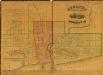
Kenosha, Wisconsin / compiled from official records by S.Y. Brande & J. Lothrop Jr. ; Snyder, Black & Sturn.
1 : 3168 This map shows land ownership by name, local streets, wards, buildings, parks, a cemetery, and part of Lake Michigan. Depths are shown by soundings and north is oriented to the right. The top of the map reads: "Population 8000." Hand annotations of green, blue, red, and yellow have been drawn around some sections. Snyder, Black & Sturn Snyder, Black & Sturn
Kenosha Harbor, Wisconsin
1 : 2400 This map was created from a survey made in December 1855 and shows local streets, proposed roads, railroads, the lake shore, bridge wharfs, the basin, the north and west arms of Kenosha Harbor, and part of Pike Creek. Relief is shown by hachures and soundings. Mayer, John R. U.S. Top. Engineers, Lake Michigan Works
Kenosha, Wisconsin : 1961
1 : 19200 This is a photocopy of a map in blue line print that shows streets and places of interest. Inscribed in pen, at the bottom of the map, reads: "Sen. Zaborski". Lake Michigan in labeled as are streets. Kenosha (Wis.). City Engineer's Office Kenosha (Wis.). City Engineer's Office
Kenosha
1 : 24000
Kenosha Harbor, Wisconsin / prepared under the direction of Charles Keller and C.S. RicheÌ.
1 : 10000 This map is a survey of Kenosha Harbor and shows local streets, public buildings, local businesses, and part of Lake Michigan. Included is text on sailing directions, lake and harbor descriptions, an explanation on abbreviations, authorities, and notes on latitude and longitude, land contours, soundings, water and water depth. At the head of the title, the map reads: "Survey of the Northern and Northwestern lakes : Made in obedience to Acts of Congress and orders from Headquarters Corps of Engineers, U.S. Army." U.S. Lake Survey U.S. Lake Survey Office
Racine
1 : 62500
Racine
1 : 62500
Racine
1 : 62500
Racine
1 : 62500
Racine
1 : 62500
Racine
1 : 62500
Racine
1 : 62500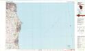
Racine
1 : 100000
Shell Metropolitan Chicago and Vicinity.
1 : 205920 Shell Oil Company
Section 1. Bicycle Road Map of Wisconsin.
1 : 253440 League of American Wheelmen, Wisconsin Division
Racine
1 : 250000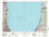
Racine
1 : 250000
Racine
1 : 250000
Racine
1 : 250000
Map of Racine and Kenosha counties, State of Wisconsin.
1 : 126720 Snyder, Van Vechten & Co.
Chicago District.
1 : 380000 Rand McNally and Company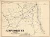
Fox River Valley R.R. in Wisconsin with its connections.
1 : 1600000 This hand colored map shows southern Wisconsin and northern Illinois and indicates county boundaries, larger cities, and some drainage. The line was chartered in 1852 and constructed in 1854. Lipman & Riddle Lipman & Riddle Lith
Wisconsin S. part.
1 : 780000 Morse, Sidney E. (Sidney Edwards), 1794-1871
Triangulation in Wisconsin
1 : 506880 This map shows names of triangulation stations, railroads, counties, rivers, and lakes. The Mississippi River, Lake Winnebago, and Lake Michigan are labeled. The upper right corner includes a key of markings. The map covers north to Eau Claire. Davies, John Eugene Wisconsin Geological Survey
Illinois.
1 : 2050000 Meyer, Joseph, 1796-1856
Wisconsin.
1 : 1340000 Mitchell, Samuel Augustus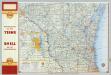
Shell Highway Map of Wisconsin (northern portion).
1 : 950400 Shell Oil Company
Illinois.
Rand McNally and Company