Maps of Hulst

HVLST : [fortification plan].
[Amsterdam : Joan Blaeu]
[Top left] HVLST : [fortification plan]; [bottom left] LIEFKENS-HOECK : [fortification plan]; [top right] AXEL : [fortification plan]; [bottom right] TER NEVSE : [fortification plan].
[Amsterdam : Joan Blaeu]
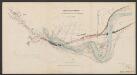
LA SIEGE DE | HULST | Per Son Altese la Prince | d'Orangie | 1645 [=] DE BELEGERINGE VAN DE STADT HULST, | door Syn Hoogheyt den Prince van Orangien | int Iaer 1645.
IB Excudit.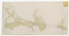
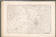
[Kaarte van de bedykte schorren tussen Hulst, Axel en Sas van Gent, zoo als de zelve in July 1790 gelegen zijn ...]

55 Hulst, uit: Topographische en militaire kaart van het Koningrijk der Nederlanden / vervaardigd door de officieren van den Generale Staf ; en gegraveerd op het Topographisch Bureau, van het Ministerie van Oorlog
1 : 50000 titelvariant: TMK; Annotatie: Met bladwijzer op schaal 1:600.000. - 1915; Met Verklaring van de topographische en militaire kaart van het Koninkrijk der Nederlanden. - 1910; Bd. 1: titelblad, bladwijzer, verklaring, bladen 1 t/m 32; Bd. 2: bladen 33 t/m 62 Generale Staf, Nederland; Ministerie van Oorlog. Topographisch Bureau ['s-Gravenhage : Ministerie van Oorlog]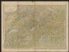
Tabula Castelli ad Sandflitam, qua simul inundati agri, alluviones, foẞae, alvei, quae Bergas ad Zomam et Antverpiam interiacent, annotantur. [Karte], in: Gerardi Mercatoris et I. Hondii Newer Atlas, oder, Grosses Weltbuch, Bd. 1, S. 381.
1 Karte aus Atlas Mercator, Gerhard und Hondius, Jodocus Jansson, Jan
TABVLA | Castelli ad Sandflitam, | qua simul inundati agri, | alluviones, fossæ, alvei, | quæ Bergas ad Zomam | et Antverpiam interjacent, | annotantur.
Excudit | Guiljelmus Blaeuw.
WASIA. | 'T Land van Waes
[Amsterdam : Joan Blaeu]
Tabula Castelli ad Sandflitam, qua simul inundati agri, alluviones, foßae, alvei, quae Bergas ad Zomam et Antverpiam interiacent, annotantur. [Karte], in: Le théâtre du monde, ou, Nouvel atlas contenant les chartes et descriptions de tous les païs de la terre, Bd. 1, S. 357.
1 Karte aus Atlas Blaeu, Willem Janszoon und Blaeu, Joan Blaeu, Willem Janszoon
Tabula Castelli ad Sandflitam, qua simul inundati agri, alluviones, foßae, alvei, quae Bergas ad Zomam et Antverpiam interjacent, annotantur. [Karte], in: Novus Atlas, das ist, Weltbeschreibung, Bd. 1, S. 330.
1 Karte aus Atlas Blaeu, Joan Blaeu, Willem Janszoon
Tabula Castelli ad Sandflitam, qua simul inundati agri, alluviones, foßae, alvei, quae Bergas ad Zomam et Antverpiam interiacent, annotantur. [Karte], in: Theatrum orbis terrarum, sive, Atlas novus, Bd. 1, S. 348.
1 Karte aus Atlas Blaeu, Joan Blaeu, Willem Janszoon
Tabula Castelli ad Sandflitam, qua Simul inundati agri, alluviones, Foßae, alvei, quae Bergas ad Zomam et Antverpiam interiacent, annotantur. [Karte], in: Novus atlas absolutissimus, Bd. 3, S. 61.
1 Karte aus Atlas Janssonius Offizin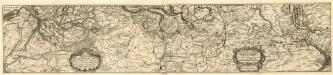
Carte Particulière Des Environs D'Une Partie Des Limites En Flandre :
1 : 80000 Mollova mapová sbírka Suly, Nicolas Scheurleer, Hendrik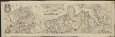
't Meerderdeel van 't Oost-Vrye in Vlaenderen vertonende d'oprechte gelegenth[eit] der landen, fortressen, schansen ende de nieuw bedijckte polders
1 : 40000 [Jac. Mogge] Te Amsterdam : gedruckt by de Wed. Ottens en Zoone ...

Bl. 30 Bergen op Zoom, 1905, uit: Atlas A.N.W.B.
1 : 200000 titelvariant: Atlas van Nederland van den A.N.W.B. Toeristenbond voor Nederland; Wielrijders-atlas van Nederland; Annotatie: Titel op bladwijzer: Atlas van Nederland van den A.N.W.B. Toeristenbond voor Nederland; Titel op legendablad: Wielrijders-atlas van Nederland; Voor aanwezige bladen zie overzichtsblad; Annotatie geografische gegevens: De serie bestaat uit 36 bladen ANWB ['s-Gravenhage : A.N.W.B.]
Tabvla casteli ad sandflitam, qua simul inundati agri, alluviones, foßae, alvei, quae Bergas ad Zomam et Antverpiam interjacent annotantur
1 : 140000 Antverpy (Belgie) Blaeu, Willem Janszoon Guiljelmus Blaeuw
Carte tres-particuliere du Pays de Waes, ou sont marqués les Lignes depuis Anvers jusques a Gand
1 : 116600 Mollova mapová sbírka Fricx, Eugène Henry Harrewyn, Jacques Fricx, Eugené Henry
Carte Particuliere des Environs d'Anvers, Gand, Hulst, et de tout le Pays de Waes, et le Marquisat du St. Empire
1 : 116600 Mollova mapová sbírka Fricx, Eugène Henry Covens, Johannes I
Niewe Kaerte van t Landt van Waes
1 : 93000 Mollova mapová sbírka Visscher, Nicolaes Schenk, Peter II
Carte Particul. des Environs d'Anvers, Gand, Hulst, et de tout le Pays de Waes. et la Marquisat du St. Empire
1 : 250000 Mollova mapová sbírka Seutter, Matthäus Lotter, Tobias Conrad Seutter, Matthäus
Nieuwe kaart van de eilanden Zuid en Noord Beveland, Wolfersdyk en de heerlykheden van Vosmaar, Tolen, Poortvliet, Martensdyk & met de nieuwe bedykinge als mede van 't marquisaat van Bergen.
1 : 40000 Te Amsterdam : bij de Wed. Ottens & Zoone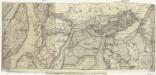
Pas-caert vande ghelege[e]theyt vande schans te Santvliet
1 : 160000 Antverpy (Belgie) Visscher, Claes Jansz. Claes Ianß Visscher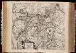
Niewe kaerte van t Landt van Waes ende Hulster Ambacht, vertoonende oock de stroomen van de Ooster ende Wester Schelde / uyt verscheyden stucken bij een gebracht door Claes Jansz. Visscher
1 : 100000 Annotatie: Origineel is Blad 42 in atlas factice; Annotatie geografische gegevens: Oost boven Visscher, Claes Jansz. [Amsterdam : C.J. Visscher excudebat]
Niewe kaerte van t Landt van Waes ende Hulster Ambacht, vertoonende oock de stroomen van de Ooster ende Wester Schelde
1 : 100000 per Nicolaum Visscher C.J. Visscher excudebat [Amsterdam] : nunc apud Pet. Schenk Junior
Carte tres-particuliere du Pays de Waes
1 : 120000 Antverpy (Belgie) Fricx, Eugene Henry chez Eugene Henry Fricx
Zelandiae Comitatus Novissima Tabvla].
1 : 45000 Mollova mapová sbírka Visscher, Nicolaes Jansz. Ottens, Aaltje
![HVLST : [fortification plan].](https://images-2.georeferencer.com/images/iiif/810659839723/full/,300/0/native.jpg)

