Maps of Spain

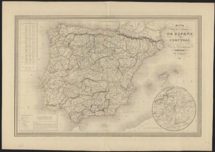
Mapa general de caminos de España y de Portugal con las nuevas divisiones de provincias sirve de continuación al Atlas nacional de España
1 : 1800000 por A.H. Dufour la geografía grabada por Desbuissons y Leclercq ; la letra grabada por Bénard Paris : Bulla
Karte von dem Iberischen Halbinsellande oder den Königreichen Spanien und Portugal
1 : 1500000 Portugalsko Berghaus, Heinrich Karl Wilhelm Brose, Heinrich J.G. Cotta's geographischer Anstalt
Karte von dem Iberischen Halbinsellande oder den Königreichen Spanien und Portugal
1 : 1500000 Portugalsko Berghaus, Heinrich Karl Wilhelm Brose, Heinrich J.G. Cotta's geographischer Anstalt

Spanien und Portugal
Geographischer Atlas über alle Theile der Erde Ziegler, Jakob Melchior Verlag von Joh. Wurster um Comp.
Hispania antiqua in tres præcipuas partes
1 Karte : Kupferdruck ; 46 x 64 cm Sanson; Remondini; Robert de Vaugondy; Santini apud Franc.m Santini chez Mr. Remondini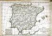
Mappa Hispaniæ antiquæ descripta
1 Karte : Kupferdruck ; 21 x 31 cm Bonne; Perrier; André s.n.
Hispania antiqua in tres præcipuas partes
1 Karte : Kupferdruck ; 46 x 56 cm Robert de Vaugondy; Sanson; Delahaye G. et D. Robert de Vaugondy
Carte de l'Espagne ancienne
1 Karte : Kupferdruck ; 39 x 49 cm Robert de Vaugondy G. Robert de Vaugondy
Hispania antiqua
1 Karte : Kupferdruck ; 40 x 52 cm Sanson; Robert de Vaugondy chés le Sr. Robert geog. ord. du roy sur le quay de l'horloge du palais
Hispania vetvs
1 Karte : Kupferdruck ; 31 x 38 cm Weigel Christoph Weigel
Hispaniae veteris descriptio
1 Karte : Kupferdruck ; 36 x 47 cm Ortelius s.n.
España: comunicaciones terrestres
Datat al 1950 aproximadament. 0 Seix y Barral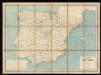
Carta itineraria de España
1 : 1500000 Depósito Central de Planos de la Dirección General de Obras Públicas
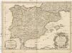
Hispania : ex archetypo Roderici Mendez Silvae et variis relationibus et chartis manu scriptis et impressis hujus regni rectificatis per Observationes Sociorum Academiae Scientiarum quae est Parisiis
1 : 3200000 per G. De L'Isle Matth. Seutter sculp. Aug. Vind : in officina Tobiae Conr. Lotter
[Spanien und Portugal, Iberische Halbinsel]
[Allgemeiner Atlas über alle Theile der Erde in 29 Blättern] Ziegler, Jakob Melchior Top. Anstalt v. J. Wurster u. Comp.
[Iberische Halbinsel]
Pyrenejský poloostrov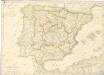
Spanien und Portugal
L'Espagne
1 : 2600000 Aragonie (Španělsko) Sanson, Guillaume Cordier, Louis chez H. Jaillot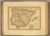
Espagne ancienne.
1 : 2800000 Picquet, C.
Spanien und Portugal
Plastischer Schul-Atlas über alle Theile der Erde : in 24 Karten Woldermann, G Verlag von P. Eckerlein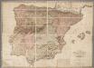
A new map of Spain and Portugal : exhibiting the chains of mountains with their passes, the principal & cross roads, with other details requisite for the intelligence of military operations / comp. by Jasper Nantiat
1 : 850000 Annotatie: Met afstandentabel Nantiat, Jasper London : W. Faden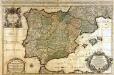
L'Espagne
1 Karte : Kupferdruck ; 53 x 85 cm Sanson; Jaillot chez H. Iaillot joignant les grands Augustins aux deux globes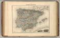
Espagne et Portugal.
1 : 3375000 Migeon, J.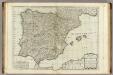
A new map of the Kingdoms of Spain and Portugal.
1 : 2230000 Kitchin, Thomas
Espagne et Portugal.
Andriveau-Goujon, J.
Espagne et Portugal.
1 : 3300000 Garnier, F. A., 1803-1863
Carte des routes de postes et itinéraires d'Espagne et de Portugal
1 : 2500000 par Ch. Picquet dressée par Lapie, Ingr. géographe, d'après les cartes de Lopez, Tofino et autres documents authentiques. Paris : chez Ch. Picquet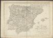
Karte von dem Iberischen Halb-Insellande, oder den Königreichen Spanien und Portugal
1 : 1500000 entworfen und in den Jahren 1826-1829 bearb. von Heinrich Berghaus gestochen von Heinrich Brose ; Schrift von Wilhelm Brose München : Cotta