Maps of Netherlands

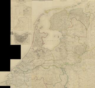
Nouvelle carte de la Hollande, d'apres Krayenhoff et les meilleurs cartes connues : 24 feuilles
1 : 115200 Établissement Géographique de Bruxelles, Fondé par Ph. Vander Maelen. Bruxelles : Etablissement geographique, fondé par Ph. Vander Maelen
[Nizozemsko]
Nizozemsko Bilderdyk, W Veelwaard, D.
Charte von der Batavischen Republik
Nizozemsko Kipferling, Karl Joseph Krayenhoff, Cornelis Rudolphus Theodorus im Verlage des Kunst und Industrie Comptoirs
Charte von der Batavischen Republik
Nizozemsko Kipferling, Karl Joseph Krayenhoff, Cornelis Rudolphus Theodorus im Verlage des Kunst und Industrie Comptoirs
Holland.
1 : 1290000 Finley, Anthony
Nieuwe kaart der Vereenigde Nederlanden
1 : 900000 Amsterdam : by Isaak Tirion
Seven United Provinces.
1 : 1460000 Bowen, Frances
Netherlands.
1 : 1290000 Hughes, William
Carte de la Hollande comprenant le Limbourg Hollandais et le Gd. Duché de Luxembourg.
1 : 450000 [Bruxelles] : Etablissement Géographique, fondé par Ph. Vandermaelen
Seven United Provinces.
1 : 950000 Playfair, Principal
Comitatus Hollandiae denuo forma leonis
1 : 570000 Alkmaar (Nizozemnsko) Visscher, Claes Jansz. Nassau-Usingen, Karel van a Nicolao Iohannis Visscher
Belgium foederatum
1 : 640000 Indonésie Seutter, Matthäus studio [Mattha]ei Seutteri
[ République Batave]
1 : 750000 Tardieu, Jean Baptiste Pierre 1746-1816 [Paris] : [Edme Mentelle
Karte der itzo vereinigten Niederlande
1 : 990000 Nizozemsko
Belgium foederatum
1 : 650000 Belgie Marianus, Joseph
Belgium Foederatum auctius et emendatius
1 : 780000 Mollova mapová sbírka Seutter, Matthäus Lotter, Tobias Conrad Seutter, Matthäus
Les Provinces Unies ou la Partie Septentrionale des Pays Bas
1 : 780000 Mollova mapová sbírka Coronelli, Vincenzo Maria Loon, Herman van Nolin, Jean Baptist François
Belgium Foederatum
1 : 620000 Mollova mapová sbírka Danckerts, Justus Danckerts, Justus
Belgium Foederatum
1 : 630000 Mollova mapová sbírka Wit, Frederik de Covens, Johannes I
Des Burgundischen Creisses Nordlicher Theil oder Vereinigte Niederlande
1 : 2200000 Mollova mapová sbírka Weigel, Christoph Weigel, Christoph I. - dědici
Holland.
1 : 1048000 Hughes, William
Belgium foederatum
1 : 630000 1 Karte : Kupferdruck ; 49 x 55 cm Danckerts, Justus [Danckerts]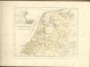

Belgium foederatum / emendatius auctum et novissimé editum per Iustinum Danckerts Amstelodami
1 : 500000 Annotatie: Cum privil. Ordin. Holl. et Westfrisiae; Annotatie geografische gegevens: Met 2 schaalstokken Justus Danckertsz 1635-1701 [Amsterdam : Justus Danckerts]

Nieuwe kaart der Vereenigde Nederlanden.
1 : 1000000 Te Amsterdam : by Isaak Tirion
Holland.
1 : 1280000 Tanner, Henry S.
Nieuwe kaart van de VII Vereenigde Provintien, volgens de nieuwste waarneemingen opgemaakt]
1 : 1650000 [S.l.] : [s.n.]