Maps of Netherlands

Belgium foederatum
1 : 650000 Belgie Marianus, Joseph
Carte de la Hollande comprenant le Limbourg Hollandais et le Gd. Duché de Luxembourg.
1 : 450000 [Bruxelles] : Etablissement Géographique, fondé par Ph. Vandermaelen
Nouvelle carte de la Hollande, d'apres Krayenhoff et les meilleurs cartes connues : 24 feuilles
1 : 115200 Établissement Géographique de Bruxelles, Fondé par Ph. Vander Maelen. Bruxelles : Etablissement geographique, fondé par Ph. Vander Maelen
[Nizozemsko]
Nizozemsko Bilderdyk, W Veelwaard, D.
Belgium foederatum
1 : 630000 1 Karte : Kupferdruck ; 49 x 55 cm Danckerts, Justus [Danckerts]

Charte von der Batavischen Republik
Nizozemsko Kipferling, Karl Joseph Krayenhoff, Cornelis Rudolphus Theodorus im Verlage des Kunst und Industrie Comptoirs
Charte von der Batavischen Republik
Nizozemsko Kipferling, Karl Joseph Krayenhoff, Cornelis Rudolphus Theodorus im Verlage des Kunst und Industrie Comptoirs
Holland.
1 : 1290000 Finley, Anthony
Netherlands.
1 : 1290000 Hughes, William
Belgium foederatum / emendatius auctum et novissimé editum per Iustinum Danckerts Amstelodami
1 : 500000 Annotatie: Cum privil. Ordin. Holl. et Westfrisiae; Annotatie geografische gegevens: Met 2 schaalstokken Justus Danckertsz 1635-1701 [Amsterdam : Justus Danckerts]
Septem provinciae Belgivm foederatvm
1 : 603000 Nizozemsko Mayer, Tobias Hom[m]anianis Heredibus
Septem provinciae Belgivm foederatvm
1 : 600000 Belgie Mayer, Tobias Musschenbroek, Petrus van Hom[m]anianis Heredibus
Septem provinciae seu Belgivm foederatvm
1 : 600000 Belgie Mayer, Tobias Musschenbroek, Petrus van edentibus Homan[n]ianis Heredibus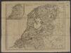
[ République Batave]
1 : 750000 Tardieu, Jean Baptiste Pierre 1746-1816 [Paris] : [Edme Mentelle
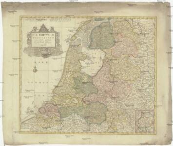
De VII. Vereenigde Nederlandsche Provincien

Seven United Provinces.
1 : 950000 Playfair, Principal
Belgium Foederatum
1 : 620000 Mollova mapová sbírka Danckerts, Justus Danckerts, Justus
Belgium Foederatum
1 : 630000 Mollova mapová sbírka Wit, Frederik de Covens, Johannes I
Belgii pars septentrionalis communi nomine vulgo Hollandia nuncupata continens statum potentissimae Batavorum reipublicae sev provincias VII foederatas
1 : 630000 Belgie Homann, Johann Baptist exhibente Io. Baptista Homanno
Belgii pars septentrionalis communi nomine vulgo Hollandia nuncupata continens statum potentissimae Batavorum reipublicae sev provincias VII foederatas
1 : 630000 Belgie Homann, Johann Baptist exhibente Io. Baptista Homanno
Belgium foederatum
1 : 625000 Maastricht (Nizozemsko) Visscher, Nicolaes Jansz. Schenk, Pieter P. Schenk iunior
Belgium foederatum
1 : 625000 Maastricht (Nizozemsko) Visscher, Nicolaes Jansz. par Nicolaum Visscher
Belgium foederatum
1 : 630000 Belgie Visscher, Nicolaus per Nicolaum Visscher
Nieuwe kaart der Vereenigde Nederlanden
1 : 900000 Amsterdam : by Isaak Tirion
Seven United Provinces.
1 : 1460000 Bowen, Frances
Kaart van het Koningrijk der Nederlanden : aantoonende de wijze waarop en de plaatsen waarheen op 1e Januarij 1857 briefpakketten worden verzonden of briefbestelling wordt verrigt op kosten van 's Rijks schatkist, benevens opgave waar op dat tijdstip E.M. telegraaf kantoren geopend waren
1 : 550000 ontworpen en geteekend door S. Gille Heringa op steen gebragt bij A.J. Bogaerts. Middelburg : J.G. en W. Altorffer
Belgica Foederata
1 : 610000 Mollova mapová sbírka Lotter, Tobias Conrad Lotter, Tobias Conrad