Maps of Frisian Islands

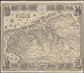
Tabula Frisiae, Groninghae, et territory Embdensis nec non circumjacentium regionum puta Transisalaniae, Benthemiae, Westphaliae, et Oldenburgi
1 : 300000 noviter summa cura et studio edita, a Nicolao Johannide Piscatore. [Amsterdam] : [Claes Jansz. Visscher]
Tabula Frisiae, Groningae, et territorii Emdensis nec non circumjacentium regionum, puta Transisalaniae, Benthemiae, Westphaliae, et Oldenburgi.
1 : 450000 [Amsterdam] : ex officina N. Visscher
Tabula Frisiae, Groningae, et Territorii Emdensis
1 : 460000 Mollova mapová sbírka Visscher, Nicolaes Schenk, Peter II
Tabula Frisiae, Groningae, et Territorii Emdensis nec non circumiacentium Regionum [...] [Karte], in: Novus atlas absolutissimus, Bd. 3, S. 223.
1 Karte aus Atlas Janssonius Offizin
Oost ende West Vrieslandts beschrijninghe. Utriusque Frisiorum Regionis Noviss: Descriptio. 1568. [Karte], in: Theatrum orbis terrarum, S. 54.
1 Karte aus Atlas Ortelius, Abraham
Oost ende West Vrieslandte beschryvinghe. Utriusque Frisiorum Regionis Noviss: Descriptio. 1568. [Karte], in: Theatrum orbis terrarum, S. 195.
1 Karte aus Atlas Ortelius, Abraham Vrients, Jan Baptista
Oldenburg
1 : 600000 Opitz, Carl Solbrig
Sect. 6: Emden, uit: Geologische Karte des Deutschen Reichs in 27 Blaettern / [von] Richard Lepsius ; Red. von C. Vogel
1 : 500000 Annotatie: Blad 18 ontbreekt; Een aantal bladen op linnen; Een aantal bladen gereviseerd 1913-1914; Annotatie geografische gegevens: Met schaalstokken o.a. in kilometers; Legenda Carl Vogel 1828-1897 Gotha : Justus Perthes
Le Theatre de Bellone :
Mollova mapová sbírka Schenk, Pieter Braakman, Adriaan
Pars II et III Frisiae liberae a Flevo in Lavicam, quae Ostfresia atque hinc in Amisiam, quae Groningana, cum Transvechtana dicione episcopatus Trajectini post eluviones seculi XIII
1 : 480000 auctore Mensone Alting G. de Broen fecit ... [Amstelaedami] : [apud Henricum Wetstenium]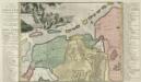
Pars II. et III. Frisiae Libera à Flevo in Lavicam quae Osteresia, atque hinc in Amisiam, quae Groningana cum Transvechtana Dicione Episcopatus Trajectini. Post eluviones seculi XIII
1 : 550000 Mollova mapová sbírka Alting, Menso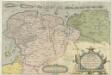
Vtrivsqve Frisiorvm Regionis Noviss: Descriptio
1 : 410000 Mollova mapová sbírka
Descriptio Frisiae Liberae inter Kinnemum et Amisiam sub Francorum reditum usque ad eluviones seculi XIII
auctore Mensone Alting Ger. de Broen fecit ... [Amstelaedami] : [apud Henricum Wetstenium]
Frisia occidentalis. [Karte], in: Gerardi Mercatoris Atlas, sive, Cosmographicae meditationes de fabrica mundi et fabricati figura, S. 334.
1 Karte aus Atlas Mercator, Gerhard Montanus, Petrus
Tabula Frisiae orientalis
1 : 210000 Aurich (Německo) Coldewey, Ehrenreich Gerhard Allard, Abraham ex officina Ioh. Christoph. Homanni
Tabula Frisiae orientalis
1 : 210000 Aurich (Německo) Coldewey, Ehrenreich Gerhard Allard, Abraham ex officina Ioh. Christoph. Homanni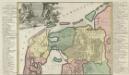
Descriptio Frisiae Liberae inter Kinnemum et Amisiam sub Francorum reditum usq; ad eluviones seculi XIII.
1 : 590000 Mollova mapová sbírka Alting, Menso Broen, Gerrit de

Frisia Occidentalis
1 : 300000 Sibrandus Leonis Leovardiensis describ. [Antwerpen] : [Abraham Ortelius]
[Kaart], uit: N.O. Nederland
1 : 300000 titelvariant: Groningen, Friesland en Drente; Ten Brink's reiskaart van Groningen, Friesland en Drente; Annotatie: Titel linksonder: Groningen, Friesland en Drente; Omslagtitel: Ten Brink's reiskaart van Groningen, Friesland en Drente : voornamelijk ten dienste van motor-, auto- en wielrijders en voor kantoor en op reis Arnhem : Ten Brink
DOMINII GRONINGEN nec non maximae partis DRENTIAE
1 : 180000 Gröningen (Německo) Visscher, Nicolaus Hooghe, Romeyn de Nicolaus Visscher excud.
DOMINII FRISIAE tabula, inter FLEVUM et LAVICAM
1 : 150000 Frísko Schotanus, Bernhard Visscher, Nicolaes Jansz. ex officina Nicolai Visscher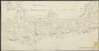
[The Waddenzee]
1 : 150000 [S.l.] : [s.n.]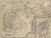
Frisia Occidentalis. [Karte] Antiquae Frisiae situs sub Augusto Imperatore, ut fertur. [Nebenkarten], in: Theatrum orbis terrarum, S. 198.
1 Karte aus Atlas Ortelius, Abraham Vrients, Jan Baptista
Nieuwe kaart van het departement van de Eems, verdeeld in VII ringen
1 : 480000 C. Covens del. C. van Baarsel sculp. Te Amsterdam : bij Mortier Covens en Zoon
Tabula comitatus Frisiae
1 : 300000 Frísko Schotanus, Bernhard Wit, Frederick de a Frederico de Witt
Frisia occidentalis
1 : 250000 Frísko Sibrandus, Leo
Nova totius provinciae Groningo-Omlandiae in Belgio tabula
1 : 200000 Groningen (Nizozemsko) edentibus Homannianis Heredibus
Frisiae occidentalis typus.
1 : 400000 [Cornelis Claesz.] [Amsterdam] : [Johannes Janssonius]