Maps of Hola Prystan Raion

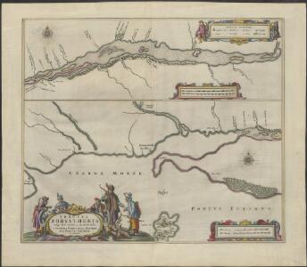
TRACTVS | BORYSTHENIS | Vulgo DNIEPR et NIEPR dicti, | à CHORTIKA OSTRO ad Urbem OCZAKOW | ubi in PONTVM EUXINUM | se exonerat.
[Amsterdam : Joan Blaeu]
Südrussische Limanküste
1 : 2000000 Ukraine, Schwarzmeerküste
Charte der Lage von Cherson, Odessa und Bender und der Ausflüsse des Dnestr's und Dnjepr's
Cherson (Ukrajina)
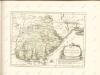
Confluent et embouchure du Bog et du Dniéper
1 Karte : Kupferdruck ; 22 x 63 cm Clerc; Dupuis Froullé
Confluent et embouchure du Bog et du Dniéper
1 : 170000 Dněpr Benedicti, Hieronymus
Confluent et embouchure du Bog et du Dniéper / gravé à Vienne par H. Benedicti
1 : 170000 1 Karte : Kupferdruck ; 22 x 63 cm Maire, François Joseph [F. J. Maire]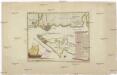
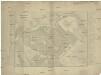
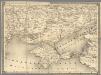
Carte der Landung und Attaque der Türken bei Kinburn den 12ten Oct. 1787
1 : 180000 Černé moře-oblast Trattner, Johann Thomas Thomas Edlen v. Trattnern k.k. Hofbuchdruck.
Carte der Landung und Attaque der Türken bei Kinburn den 12ten Oct. 1787
1 : 180000 Černé moře-oblast Thomas Edlen v[on] Trattner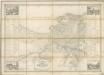
Plan Goroda Odessy
Plan goroda Odessy sostavlennyj v 1843 godu
1 : 7600 Oděsa (Ukrajina) Klenov, D.
Ichnographia munitissimae arcis Otzakoff quae Ao 1737. die 3 iulii auspiciis supremi campi mareschalli comitis de Münnich ab exercitu Russorum vi occupata
1 : 3700 Seutter, Matthäus â Matth. Seuttero

Plan veritable de la fameuse forteresse d'Oczakow
Du Chaffat, Antoine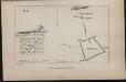
Plan Aleškovskoj Siči
Ukraine Saporoschje (Region) Saporoger Kosaken
Special-Karte des Kriegsschauplatzes in Süd-Russland
1 : 420000 Rusko jižní Handtke, Friedrich C. Flemming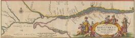
Tractus Borysthenis Vulgo Dniepr et Niepr dicti, à Kiovia ad Urbum Oczakow ubi in pontum Euxinum se exonerat. [Karte, Teil 3], in: Novus atlas absolutissimus, Bd. 1, S. 73.
1 Karte aus Atlas Janssonius Offizin
[Dnjepr-Mündung]
1 Karte : Kupferdruck ; 18 x 13 cm [Trattner]
Bessarabia. Podolia. Lithuasia
Mollova mapová sbírka Hoffmann, Johannes Hoffmann, Johann
14. Cherson
1 : 1400000 Schubert, Friedrich Theodor
Scythia Europaea Et Asiatica Cum Chersoneso Taurica Ante et Post Christum Natum ad Seculum V
1 : 6500000 Mollova mapová sbírka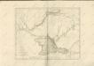

Theatrum belli Ao. MDCCXXXVII a milite Augustae Russorum Imperatricis adversus Turcas Tattarosque ge
1 : 1900000 1 Karte : Kupferdruck ; 46 x 65 cm apud R. & I. Ottens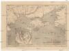
Bojiště černomořské
Krym (Ukrajina)
Gouv. 24. Woronesh, 28. Slobodsk Ukraïne
1 : 2200000 1 Karte : Lithographie ; 20 x 26 cm Schlieben, W.E.A. von [Georg Joachim Göschen]
I governi di Moscovia, di Niz-Novogorod e di Kazan
1 : 4900000 1 Karte : Kupferdruck ; 22 x 31 cm Presso Pazzini Carli
Theatrum belli a.o MDCCXXXVII & XXXVIII a milite augustae russorum imperatricis adversus Turcas Tatt
1 : 2000000 1 Karte : Kupferdruck ; 48 x 66 cm apud Joan Block