Maps of Олешківський район
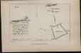
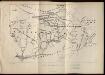
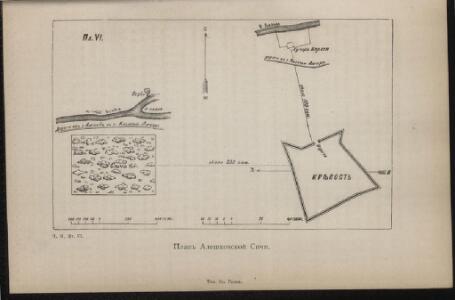
Plan Aleškovskoj Siči
Ukraine Saporoschje (Region) Saporoger Kosaken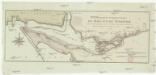
Confluent et embouchure du Bog et du Dniéper
1 : 170000 Dněpr Benedicti, Hieronymus
Confluent et embouchure du Bog et du Dniéper / gravé à Vienne par H. Benedicti
1 : 170000 1 Karte : Kupferdruck ; 22 x 63 cm Maire, François Joseph [F. J. Maire]
TRACTVS | BORYSTHENIS | Vulgo DNIEPR et NIEPR dicti, | à CHORTIKA OSTRO ad Urbem OCZAKOW | ubi in PONTVM EUXINUM | se exonerat.
[Amsterdam : Joan Blaeu]
[Dnjepr-Mündung]
1 Karte : Kupferdruck ; 18 x 13 cm [Trattner]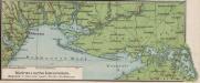
Südrussische Limanküste
1 : 2000000 Ukraine, Schwarzmeerküste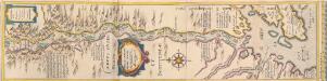
[Dniepr Fluvius A Ptolomeo Borystenes Vocatus] [Karte, Teil 2], in: Novus Atlas, das ist, Weltbeschreibung, Bd. 1, S. 70.
1 Karte aus Atlas Blaeu, Joan Blaeu, Willem Janszoon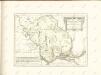

Carte de la Crimée
1 : 1900000 1 Karte : Kupferdruck ; 17 x 21 cm Bellin, Jacques Nicolas [Bellin]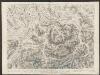
Campus Inter Bohum et Borystenem [und] Campus Inter Bohum & Borystenem [Karte, Teil 2], in: Theatrum orbis terrarum, sive, Atlas novus, Bd. 1, S. 93.
1 Karte aus Atlas Blaeu, Joan Blaeu, Willem Janszoon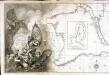
Carte de la mer noire et de la mer d'Asow, 1
1 Blatt : 57 x 86 cm s.n.
Bessarabia. Podolia. Lithuasia
Mollova mapová sbírka Hoffmann, Johannes Hoffmann, Johann
Crimée
Nouvel atlas physique politique et historique de l'Empire ottoman et des états limitrophes en Europe, en Asie et en Afrique, en quarante feuilles Hellert, J.J. Bellizard, Dufour et Cie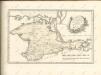

Special-Karte des Kriegsschauplatzes in Süd-Russland
1 : 420000 Rusko jižní Handtke, Friedrich C. Flemming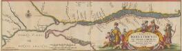
Tractus Borysthenis Vulgo Dniepr et Niepr dicti, à Kiovia ad Urbum Oczakow ubi in pontum Euxinum se exonerat. [Karte, Teil 3], in: Novus atlas absolutissimus, Bd. 1, S. 73.
1 Karte aus Atlas Janssonius Offizin
[Dniepr Fluvius A Ptolomeo Borystenes Vocatus] [Karte, Teil 1], in: Le théâtre du monde, ou, Nouvel atlas contenant les chartes et descriptions de tous les païs de la terre, Bd. 1, S. 83.
1 Karte aus Atlas Blaeu, Willem Janszoon und Blaeu, Joan Blaeu, Willem Janszoon
Post Karte von der Halbinsel Taurien oder Krim / H. Benedicti sc
1 : 1100000 1 Karte : Kupferdruck ; 27 x 41 cm Benedicti, Hieronymus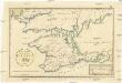
Post Karte von der Halbinsel Taurien oder Krim
1 : 1000000 Krym (Ukrajina) Benedicti, Hieronymus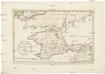
Post Karte von der Halbinsel Taurien oder Krim
1 : 1000000 Krym (Ukrajina) Benedicti, Hieronymus
Die Krymm
1 : 1680000 Feodosija (Ukrajina) Flemming, Karl druck u. Verlag v. C. Flemming
Die Krymm
1 : 680000 Anapa (Rusko) Flemming, C. C. Flemming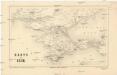
Karte der Krim
1 : 1484000 Krym (Ukrajina) Leopold Sommer
Tractus Borysthenis vulgo Dniepr et Niepr dicti, a Kiovia ad urbum Oczakow ubi in Pontum Euxinum se exonerat
1 : 462500 Dněpr Schenk, Pieter Valk, Gerhard P. Schenk et G. Valk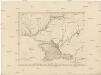
Karte Tauriens oder der Halbinsel Krim und der westlichen Nogayischen Tatarei
1 : 760000 Krym (Ukrajina) Schmidt, Jacob Friedrich Schraembl, Franz Anton F.A. Schraembl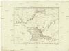
Karte Tauriens oder der Halbinsel Krim und der westlichen nogayischen Tatarei
1 : 763000 Krym (Ukrajina) Schmidt, Jacob Friedrich Schraembl, Franz Anton F.A. Schraembl
Die Krymm [i.e. Krim]
1 : 1680000 Druck u. Verlag v. C. Flemming
Carte de la Mer d'Azof et d'une partie de la Mer Noire / levée en 1774 par Monsieur Kinsbergen, Cap
1 : 1600000 1 Karte : Kupferdruck ; 19 x 45 cm Kinsbergen, Jan Hendrik van Froullé
Tavrie
Azovské moře-oblast (Ukrajina a Rusko)