Maps of Europe

L'Evrope
1 Karte : Kupferdruck ; 37 x 49 cm Jaillot; Berey chez H. Iailliot proche les Augustins
Nova Europae descriptio
1 Karte : Kupferdruck ; 44 x 54 cm Danckerts Danckerts
Europa
1 Karte : Kupferdruck ; 33 x 45 cm Merian Matthäus Merian
Mittelbach's neueste Reise- Hand- und Kontorkarte von Europa
1 : 5500000 Afrika severní Mittelbach's Verlag
Accuratissima Europæ tabula
1 Karte : Kupferdruck ; 49 x 58 cm Allard ex officina I. Cóvens et C. Mortier
Nova et accurate divisa in regna et regiones præcipuas Europæ descriptio
1 Karte : Kupferdruck ; 43 x 53 cm Wit ex officina I. Cóvens et C. Mortier
Europa excultissima
1 Karte : Kupferdruck ; 48 x 57 cm Schenk Pieter Schenk
Accuratissima Europæ tabula
1 Karte : Kupferdruck ; 48 x 57 cm Allard Carel Allard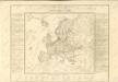

Europa

Europa
1 : 7500000 Evropa Herrich, Alwin Carl Flemming u. C.T. Wiskott
[Evropa]
Evropa
Accuratissima Europæ tabula
1 Karte : Kupferdruck ; 48 x 56 cm Danckerts Danckerts
Nova et accurata totius Europæ descriptio
1 Karte : Kupferdruck ; 47 x 56 cm Danckerts Danckerts
Accuratissima Europae tabula
1 : 10000000 1 Karte : Kupferdruck ; 48 x 56 cm Danckerts, Justus [Danckerts]
Europa
Allgemeiner Atlas [Walch, Johannes] im Verlag bei Johannes Walch
Carte demonstrative des determinations astronomiques de latitude et d'azimuth
1 : 10000000 Institut topographique militaire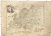
L'Europe
1 : 11930000 Evropa Le Rouge, Georges-Louis Cassini de Thury Le Rouge
Europa
1 Karte : Kupferdruck ; 45 x 53 cm Götze im Verlage des Geograph: Instituts
Europa
1 Karte : Kupferdruck ; 45 x 55 cm Götze im Verlage des Geograph. Instituts
Europa
1 Karte : Kupferdruck ; 46 x 54 cm Götze im Verlage des Geograph. Instituts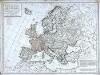
Carte politique de l'Europe
1 Karte : Kupferdruck ; 50 x 68 cm Poirson; Jean; Brion de la Tour chez Jean rue Jean de Beauvais no. 10
Carte politique hydrographique [et] routiere de l'Europe
1 Karte : Kupferdruck ; 48 x 54 cm Champion; Hinrichs chez J. C. Hinrichs libraire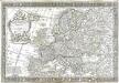
L'Europe
1 Karte : Kupferdruck ; 43 x 66 cm Nolin; Boniselle; Jean chez Jean rue Jean de Beauvais no. 32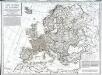
Carte politique de l'Europe
1 Karte : Kupferdruck ; 50 x 68 cm Poirson; Jean; Brion de la Tour chez Jean rue Jean de Beauvais no. 32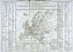
Tableau général de l'Europe
1 Karte : Kupferdruck ; 35 x 44 cm, Bildgrösse: 52 x 73 cm Brion de la Tour; Le Campion; Le Campion chés les Campion freres m.ds d'estampes rue St. Jacques près la f.e S. Severin à la ville de Rouen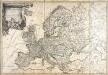
L'Europe
1 Karte : Kupferdruck ; 49 x 73 cm Brion de la Tour; Esnault; Rapilly chez Esnauts et Rapilly rue St. Jacques à la ville de Coutances
Nova et accurate divisa in regna et regiones praecipuas Europae descriptio
1 : 10000000 per F. de Witt Amstelodami [Amsterdam] : ex officina I. Cóvens et C. Mortier
Europa
1 : 10000000 Evropa


