Maps of Maslianico
Strittige Grenze zwischen der Schweiz und dem Herzogtum Mailand bei Chiasso, Pedrinate, Novazzano, Monte Lompino, Caualasca, Parè, Drezzo und Ronago; Grundriss
1 : 8000 Mit Legende und 2 Siegeln. Portigliotti, Gaudenzo, Ingenieur; Caresana, Giuseppe, Ingenieur
Chiasso TI: Bach Faloppia zwischen Seseglio und Bresciano; Grundriss
Datumsangabe auf der Rückseite. Caresana, Giuseppe, Ingenieur, von Tureglia
Grenze zwischen der Schweiz und dem Herzogtum Mailand bei Genestrerio, Stabio und Bizzarone; Grundriss
1 : 8000 Mit Legende. Caresana, Giuseppe, Ingenieur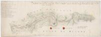
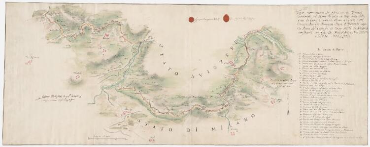
Strittige Grenze zwischen der Schweiz und dem Herzogtum Mailand bei Vacallo, Sagno, Morbio superiore, Caneggio, Bruzella, Schignano, Mezzena, Moltrasio, Rovena, Piazza und Masilianico; Grundriss
1 : 8000 Mit Legende und 2 Siegeln. Portigliotti, Gaudenzo, Ingenieur; Caresana, Giuseppe, Ingenieur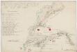
Strittige Grenze zwischen der Schweiz und dem Herzogtum Mailand bei Novazzano, Genestrerio, Stabio, Ligornetto, Bizzarone, Rodero, Ligurno und Clivio; Grundriss
1 : 8000 Mit Legende und 2 Siegeln. Portigliotti, Gaudenzo, Ingenieur; Caresana, Giuseppe, Ingenieur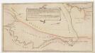
Grenze zwischen der Schweiz und dem Herzogtum Mailand bei Stabio und Clivio; Grundriss
1 : 6000 Mit Legende.
Die schweizerischen Landvogteyen Lauis und Mendris nebst den Grentzen von Bellenz, Luggaris und mayländischen Gebiet
1 Karte : Kupferdruck ; 46 x 37 cm Finsler; Clausner s.n.
[Comer See und Umgebung]
1 : 256000 Alpy italské (pohoří)
Generalkarte der Gotthardbahn
1 : 100000 Südblatt im Verlag von Orell Füssli & Co.
<<Die>> schweizerischen Landvogteyen Lauis und Mendris nebst den Grentzen von Bellenz, Luggaris und mayländischen Gebiet
1 : 90000 1 Karte dessta di G. Conr. Finsler ; gravé par [Jakob Joseph] Clausner [Ludwig von Meiss], [Erscheinungsort nicht ermittelbar]
Parte alpeste dello stato di Milano
Mollova mapová sbírka
Topographische Karte der Schweiz
1 : 100000 25 Karten vermessen und hrsg. auf Befehl der Eidgenössischen Behörden ; aufgenommen unter der Aufsicht des Generals G.H. Dufour Eidg. Topographisches Bureau, [Genève], [später: Bern]
Blatt XXIV: Lugano, Como, uit: Topographische Karte der Schweiz / vermessen und hrsg. ... unter Aufsicht des Generals G.H. Dufour
1 : 100000 Annotatie: Met plaatsnamenregister (bl. V), bladwijzer (bl. XXI) en hoogteregister (bl. XXV); Voor aanwezige bladen zie overzichtsblad Dufour, G. H. [Bern : Eidg. Topogr. Bureau]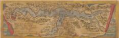
Larii Lacus Vulgo Comensis Descriptio [Karte], in: Theatrum orbis terrarum, S. 85.
1 Karte aus Atlas Ortelius, Abraham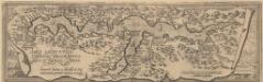
Larii Lacus Culgo Comensis Descirptio [Karte], in: Theatrum orbis terrarum, S. 309.
1 Karte aus Atlas Ortelius, Abraham Vrients, Jan Baptista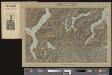
Lugano
1 Vogelschaukarte Orell Füssli, Zürich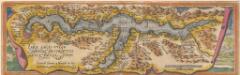
Larii Lacus Culgo Comensis Descirptio [Karte], in: Theatrum orbis terrarum, S. 214.
1 Karte aus Atlas Ortelius, Abraham
Stehende Gewässer
Atlas der Hydrographie Berghaus, Hermann Justus Perthes
Nuova carta topografica dei tre laghi Maggiore, di Lugano e di Como
1 : 180000 Como, jezero (Itálie) Ostinelli, Carlo Antonio C. A. Ostinelli
<<Der>> Canton Ticino
1 : 350000 1 Karte gezeichnet v. H. Keller nach Paolo Ghiringelli ; gest. von J.J. Scheurmann [Orell Füssli & Comp.], [Zürich]
Majeure partie des cantons de Bellinzona et de Lugano et les frontières de la République Italienne
1 : 108000 Weiss, Johann Heinrich ; Guérin, Christophe ; Meyer, Johann Rudolf J. R. Meyer
Oberitalienischen Seen und ihr Excursionsgebiet
1 : 150000 Becker, Fridolin Alfred Arnold
Carta del Cantone di Ticino
1 : 250000 Keller, Heinrich ; Hardmeier, C. ; Grimminger, Adolf Enrico Füssli & Co.

Milano
1 : 200000 Herder, Bartholomew
Canton Ticino
1 : 350000 Keller, Heinrich ; Scheuermann, Johann Jakob Orell, Füssli & Cp.
Carta dei contorni di Milano per l'opera Milano e il suo territorio
1 : 166000 Allodi incise. Milano : presso Ferd. Artaria e Figlio
Carta di viaggio da Milano ai tre laghi Maggiore di Lugano e di Como e nelle loro vicinanze
1 : 170000 Como, jezero (Itálie)
Rete trigonometrical del Cantone Ticino
1 : 250000 Ufficio topografico federale