Maps of Como

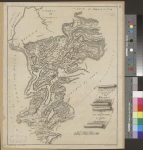
<<Die>> schweizerischen Landvogteyen Lauis und Mendris nebst den Grentzen von Bellenz, Luggaris und mayländischen Gebiet
1 : 90000 1 Karte dessta di G. Conr. Finsler ; gravé par [Jakob Joseph] Clausner [Ludwig von Meiss], [Erscheinungsort nicht ermittelbar]
Stehende Gewässer
Atlas der Hydrographie Berghaus, Hermann Justus Perthes
Generalkarte der Gotthardbahn
1 : 100000 Südblatt im Verlag von Orell Füssli & Co.
Blatt XXIV: Lugano, Como, uit: Topographische Karte der Schweiz / vermessen und hrsg. ... unter Aufsicht des Generals G.H. Dufour
1 : 100000 Annotatie: Met plaatsnamenregister (bl. V), bladwijzer (bl. XXI) en hoogteregister (bl. XXV); Voor aanwezige bladen zie overzichtsblad Dufour, G. H. [Bern : Eidg. Topogr. Bureau]
Topographische Karte der Schweiz
1 : 100000 25 Karten vermessen und hrsg. auf Befehl der Eidgenössischen Behörden ; aufgenommen unter der Aufsicht des Generals G.H. Dufour Eidg. Topographisches Bureau, [Genève], [später: Bern]
[Comer See und Umgebung]
1 : 256000 Alpy italské (pohoří)
Parte alpeste dello stato di Milano
Mollova mapová sbírka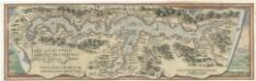
Larii Lacvs Uvlgo Comensis Descriptio
Mollova mapová sbírka Giovio, Paolo Coppens van Diest, Gillis
Die schweizerischen Landvogteyen Lauis und Mendris nebst den Grentzen von Bellenz, Luggaris und mayländischen Gebiet
1 Karte : Kupferdruck ; 46 x 37 cm Finsler; Clausner s.n.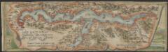
Larii Lacus vulgo Comensis descriptio : excurrit Larius a Meridie in Septentrionem, pronior tamen in Oriente
1 : 150000 auct. Paulo Jovio [S.l.] : [s.n.]
Larii lacvs vvlgo Comensis descriptio
3 Karten auf 1 Blatt : Kupferdruck ; zusammen 34 x 49 cm Giovio; Ortelius s.n.
Larii lacvs vvlgo Comensis descriptio
3 Karten auf 1 Blatt : Kupferdruck ; 34 x 49 cm Giovio; Ortelius s.n.
Bellinzona TI bis Lugano TI: Strasse von Bellinzona nach Lugano sowie von Lugano nach Ponte Tresa und Fornasette; Grundriss
Mit Legende. Fossati, Giuseppe
Carta delle profondità del Ceresio o lago di Lugano
1 : 40000 Lavizzari, Luigi [Tip. e Lit. Cantonale]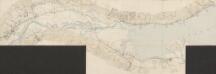
Gotthardbahn
1 : 25000 [s.n.]
Gotthardbahn: Bellinzona - Locarno
1 : 25000 [s.n.]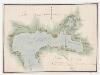
Agno TI bis Porto Ceresio (Italien): Westlicher Teil des Luganersees; Grundriss
Mit Legende.
Lugano e dintorni
1 : 25000 Annotatie: Riporto 1897; Annotatie geografische gegevens: Met schaalstok: meter Ufficio topogr. federale, Bern [Bern : Ufficio topogr. federale] / (Berna : Fratelli Kümmerly)
Carte delle valli del Liro e di Livio
1 : 50000 Grassi
Agno TI bis Porto Ceresio (Italien): Westlicher Teil des Luganersees; Grundriss
Ohne Datumsangabe.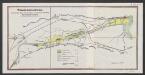
Tessinkorrektion
1 : 25000 Geobotanisches Institut, Stiftung Rübel (Zürich) [s.n.]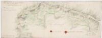
Strittige Grenze zwischen der Schweiz und dem Herzogtum Mailand bei Lugano, Brè, Cadro und Sonvico; Grundriss
1 : 8000 Mit 2 Siegeln. Portigliotti, Gaudenzo, Ingenieur; Caresana, Giuseppe, Ingenieur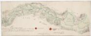
Strittige Grenze zwischen der Schweiz und dem Herzogtum Mailand bei Monteggio, Castel Rotto, Caslano, Cremenaga, Viconago und Lavena; Grundriss
1 : 8000 Mit 2 Siegeln. Portigliotti, Gaudenzo, Ingenieur; Caresana, Giuseppe, Ingenieur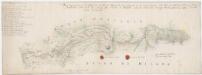
Strittige Grenze zwischen der Schweiz und dem Herzogtum Mailand bei Vacallo, Sagno, Morbio superiore, Caneggio, Bruzella, Schignano, Mezzena, Moltrasio, Rovena, Piazza und Masilianico; Grundriss
1 : 8000 Mit Legende und 2 Siegeln. Portigliotti, Gaudenzo, Ingenieur; Caresana, Giuseppe, Ingenieur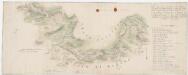
Strittige Grenze zwischen der Schweiz und dem Herzogtum Mailand bei Chiasso, Pedrinate, Novazzano, Monte Lompino, Caualasca, Parè, Drezzo und Ronago; Grundriss
1 : 8000 Mit Legende und 2 Siegeln. Portigliotti, Gaudenzo, Ingenieur; Caresana, Giuseppe, Ingenieur
Strittige Grenze zwischen der Schweiz und dem Herzogtum Mailand bei Caprino, Gandria, Castagnola, Lugano, Rogno, Rovio, Rampogno, Lanzo und Sante Fedele; Grundriss
1 : 8000 Mit 2 Siegeln. Ohne Datumsangabe. Portigliotti, Gaudenzo, Ingenieur; Caresana, Giuseppe, Ingenieur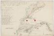
Strittige Grenze zwischen der Schweiz und dem Herzogtum Mailand bei Novazzano, Genestrerio, Stabio, Ligornetto, Bizzarone, Rodero, Ligurno und Clivio; Grundriss
1 : 8000 Mit Legende und 2 Siegeln. Portigliotti, Gaudenzo, Ingenieur; Caresana, Giuseppe, Ingenieur
Strittige Grenze zwischen der Schweiz und dem Herzogtum Mailand bei Rovio, Castel San Pietro, Muggio, Cabbio, Bruzella, Caneggio, Sante Fedele, Erbon, Cerano, Casasco und Schignano; Grundriss
1 : 8000 Mit Legende und 2 Siegeln. Portigliotti, Gaudenzo, Ingenieur; Caresana, Giuseppe, Ingenieur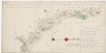
Strittige Grenze zwischen der Schweiz und dem Herzogtum Mailand bei Astano, Sessa, Monteggio, Dumenzo und Luvino; Grundriss
1 : 8000 Mit Legende und 2 Siegeln. Portigliotti, Gaudenzo, Ingenieur; Caresana, Giuseppe, Ingenieur