Maps of Vysoká nad Labem

Indikační skica mapy stabilního katastru pro obec Vysoká nad Labem IV.
1 : 2880
Wisoka - c8949-1-002 - Kaiserpflichtexemplar der Landkarten des stabilen Katasters
1 : 2880
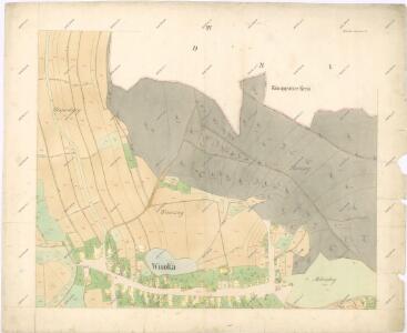
Wisoka - c8949-1-008 - Kaiserpflichtexemplar der Landkarten des stabilen Katasters
1 : 2880
Wisoka - c8949-1-005 - Kaiserpflichtexemplar der Landkarten des stabilen Katasters
1 : 2880
Wisoka - c8949-1-004 - Kaiserpflichtexemplar der Landkarten des stabilen Katasters
1 : 2880
Wisoka - c8949-1-007 - Kaiserpflichtexemplar der Landkarten des stabilen Katasters
1 : 2880
Wisoka - c8949-1-001 - Kaiserpflichtexemplar der Landkarten des stabilen Katasters
1 : 2880
Wisoka - c8949-1-003 - Kaiserpflichtexemplar der Landkarten des stabilen Katasters
1 : 2880
Wisoka - c8949-1-006 - Kaiserpflichtexemplar der Landkarten des stabilen Katasters
1 : 2880
Porostní mapa revíru Vysoká nad Labem
1 : 15000
Mapa dřevin revíru Vysoká nad Labem
1 : 15000
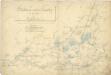
Plán zátopy Labe u Opatovic s úpravou z r. 1786 a 1894

Mapa revíru Vysoká nad Labem
1 : 10000
Raudniczka - c6561-1-003 - Kaiserpflichtexemplar der Landkarten des stabilen Katasters
1 : 2880
Raudniczka - c6561-1-001 - Kaiserpflichtexemplar der Landkarten des stabilen Katasters
1 : 2880
Raudniczka - c6561-1-002 - Kaiserpflichtexemplar der Landkarten des stabilen Katasters
1 : 2880
Geometrischer Grund Kiess Über den Neuen durchschnidt der Elbe...

Přehlední [sic] mapa lesního majetku král. věnného města Hradce Králové
Hradec Králové-oblast (Česko) Rotter, Ottomar Renard
Gradkartenblatt
1 : 25000 Hradec Králové-oblast (Česko) Hallada, Alois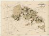
Uibersichtskarte der Daschitzer Domänenforste 1871
Dašice-oblast (Česko) Le-Monnier, Franz von Šafařík, Pavel Josef Verlag des böhm. Forst Vereins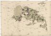
Uibersichtskarte der Daschitzer Domänenforste 1871
Dašice-oblast (Česko) Le-Monnier, Franz von Šafařík, Pavel Josef
Některé vodní stavby z 15. a 16. století na Pardubicku

Domäne Daschitz
1 : 57600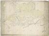
Mapa tzv. Horních revírů (albrechtický, bělečský, holický, hrádecký, chvojenecký a vysocký)
1 : 13500
Königgrätz u. Umgebung
1 : 75000 Hradec Králové (Česko : oblast) Landesvermessungsamt Böhmen u. Mähren
Hradec Králové a okolí
1 : 75000 Hradec Králové (Česko : oblast) Vojenský zeměpisný ústav
Königgratz, Elbeteinitz und Pardubitz
1 : 75000 Hradec Králové (Česko : oblast) Fenzl K. u. k. militär-geographisches Institut
Königgratz, Elbeteinitz und Pardubitz
1 : 75000 Hradec Králové (Česko : oblast) Fenzl K. u. k. Militärgeographisches Institut