Maps of Albrechtice nad Orlicí

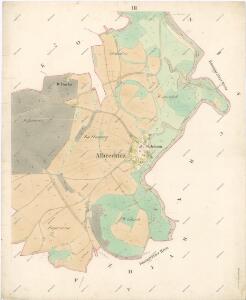
Indikační skica mapy stabilního katastru pro obec Albrechtice nad Orlicí III.
1 : 2880
Indikační skica mapy stabilního katastru pro obec Štěpánovsko IX.
1 : 2880
Albrechtitz - c0016-1-001 - Kaiserpflichtexemplar der Landkarten des stabilen Katasters
1 : 2880
Albrechtitz - c0016-1-003 - Kaiserpflichtexemplar der Landkarten des stabilen Katasters
1 : 2880
Albrechtitz - c0016-1-002 - Kaiserpflichtexemplar der Landkarten des stabilen Katasters
1 : 2880
Indikační skica mapy stabilního katastru pro obec Nová Ves I., V.
1 : 2880
Indikační skica mapy stabilního katastru pro obec Nová Ves II., IV.
1 : 2880
Tinischt - c8157-1-004 - Kaiserpflichtexemplar der Landkarten des stabilen Katasters
1 : 2880
Tinischt - c8157-1-003 - Kaiserpflichtexemplar der Landkarten des stabilen Katasters
1 : 2880
Tinischt - c8157-1-002 - Kaiserpflichtexemplar der Landkarten des stabilen Katasters
1 : 2880
Tinischt - c8157-1-001 - Kaiserpflichtexemplar der Landkarten des stabilen Katasters
1 : 2880
Tinischt - c8157-1-005 - Kaiserpflichtexemplar der Landkarten des stabilen Katasters
1 : 2880
Neudorf (Nowa Wes) - c5214-1-004 - Kaiserpflichtexemplar der Landkarten des stabilen Katasters
1 : 2880
Neudorf (Nowa Wes) - c5214-1-002 - Kaiserpflichtexemplar der Landkarten des stabilen Katasters
1 : 2880
Neudorf (Nowa Wes) - c5214-1-005 - Kaiserpflichtexemplar der Landkarten des stabilen Katasters
1 : 2880
Neudorf (Nowa Wes) - c5214-1-001 - Kaiserpflichtexemplar der Landkarten des stabilen Katasters
1 : 2880
Neudorf (Nowa Wes) - c5214-1-003 - Kaiserpflichtexemplar der Landkarten des stabilen Katasters
1 : 2880
III. vojenské mapování 3956/1
1 : 25000

Gradkartenblatt
1 : 25000 Třebechovice pod Orebem-oblast (Česko) Böhm, Karl
Mapa politického okresu Pardubického


Domäne Daschitz
1 : 57600
Mapa tzv. Horních revírů (albrechtický, bělečský, holický, hrádecký, chvojenecký a vysocký)
1 : 13500
Okres Rychnov nad Kněžnou
Königgrätz u. Umgebung
1 : 75000 Hradec Králové (Česko : oblast) Landesvermessungsamt Böhmen u. Mähren
Hradec Králové a okolí
1 : 75000 Hradec Králové (Česko : oblast) Vojenský zeměpisný ústav
III. vojenské mapování 3956
1 : 75000
Rychnov n. Kněž
1 : 75000 Rychnov nad Kněžnou (Česko : oblast) Vojenský zeměpisný ústav