Maps of Vojtěchov

Mapa vsí Kladno a Oldříš
1 : 3670
Wogtechow - c8744-1-004 - Kaiserpflichtexemplar der Landkarten des stabilen Katasters
1 : 2880
Wogtechow - c8744-1-005 - Kaiserpflichtexemplar der Landkarten des stabilen Katasters
1 : 2880
Wogtechow - c8744-1-002 - Kaiserpflichtexemplar der Landkarten des stabilen Katasters
1 : 2880
Wogtechow - c8744-1-001 - Kaiserpflichtexemplar der Landkarten des stabilen Katasters
1 : 2880
Wogtechow - c8744-1-003 - Kaiserpflichtexemplar der Landkarten des stabilen Katasters
1 : 2880
Mapa vsi Vojtěchov
1 : 3713
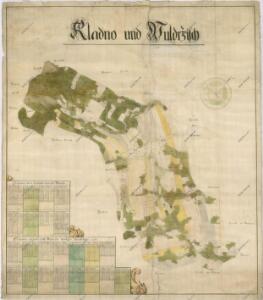
Kladno - c3107-1-002 - Kaiserpflichtexemplar der Landkarten des stabilen Katasters
1 : 2880
Kladno - c3107-1-003 - Kaiserpflichtexemplar der Landkarten des stabilen Katasters
1 : 2880
Kladno - c3107-1-001 - Kaiserpflichtexemplar der Landkarten des stabilen Katasters
1 : 2880
Diedowa (Dědowa) - c1100-1-001 - Kaiserpflichtexemplar der Landkarten des stabilen Katasters
1 : 2880
Diedowa (Dědowa) - c1100-1-002 - Kaiserpflichtexemplar der Landkarten des stabilen Katasters
1 : 2880
Diedowa (Dědowa) - c1100-1-003 - Kaiserpflichtexemplar der Landkarten des stabilen Katasters
1 : 2880
Diedowa (Dědowa) - c1100-1-004 - Kaiserpflichtexemplar der Landkarten des stabilen Katasters
1 : 2880
Indikační skica mapy stabilního katastru pro obec Oldřiš
1 : 2880
Woldrzisch - c5426-1-001 - Kaiserpflichtexemplar der Landkarten des stabilen Katasters
1 : 2880
Indikační skica mapy stabilního katastru pro obec Vojtěchov
1 : 2880
Katastrální mapa pro obec Vojtěchov
1 : 2880
Katastrální mapa pro obec Vojtěchov
1 : 2880
Indikační skica mapy stabilního katastru pro obec Vojtěchov
1 : 2880
Mapa vsi Krouna
1 : 3626
Indikační skica mapy stabilního katastru pro obec Raná
1 : 2880
Ranna - c6429-1-002 - Kaiserpflichtexemplar der Landkarten des stabilen Katasters
1 : 2880
Ranna - c6429-1-003 - Kaiserpflichtexemplar der Landkarten des stabilen Katasters
1 : 2880
Ranna - c6429-1-001 - Kaiserpflichtexemplar der Landkarten des stabilen Katasters
1 : 2880
Náčrt mapy propachtovaných pozemků u dědovského vrchnostenského dvora u osady Filipov
1 : 2880
Mapa dominikální osady Pláňavy
1 : 2880
Indikační skica mapy stabilního katastru pro obec Vojtěchov
1 : 2880
Katastrální mapa pro obec Vojtěchov
1 : 2880