Maps of Kameničky

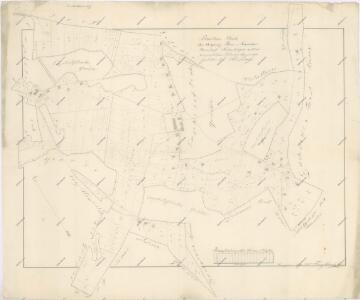
Náčrt mapy propachtovaných pozemků u dědovského vrchnostenského dvora u osady Filipov
1 : 2880
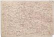
Diedowa (Dědowa) - c1100-1-001 - Kaiserpflichtexemplar der Landkarten des stabilen Katasters
1 : 2880
Diedowa (Dědowa) - c1100-1-002 - Kaiserpflichtexemplar der Landkarten des stabilen Katasters
1 : 2880
Diedowa (Dědowa) - c1100-1-003 - Kaiserpflichtexemplar der Landkarten des stabilen Katasters
1 : 2880
Diedowa (Dědowa) - c1100-1-004 - Kaiserpflichtexemplar der Landkarten des stabilen Katasters
1 : 2880
Kamenitschek (Kamenjczek) - c3009-1-003 - Kaiserpflichtexemplar der Landkarten des stabilen Katasters
1 : 2880
Kamenitschek (Kamenjczek) - c3009-1-004 - Kaiserpflichtexemplar der Landkarten des stabilen Katasters
1 : 2880
Kamenitschek (Kamenjczek) - c3009-1-001 - Kaiserpflichtexemplar der Landkarten des stabilen Katasters
1 : 2880
Kamenitschek (Kamenjczek) - c3009-1-002 - Kaiserpflichtexemplar der Landkarten des stabilen Katasters
1 : 2880
Mapa vsí Chlumětín, Kameničky a Jeníkov
1 : 3713
Mapa vrchnostenského dvora ve Lhotách
1 : 3713
Mapa vsí Kladno a Oldříš
1 : 3670
Chlumietin (Chlumětjn) - c2526-1-001 - Kaiserpflichtexemplar der Landkarten des stabilen Katasters
1 : 2880
Chlumietin (Chlumětjn) - c2526-1-004 - Kaiserpflichtexemplar der Landkarten des stabilen Katasters
1 : 2880
Chlumietin (Chlumětjn) - c2526-1-002 - Kaiserpflichtexemplar der Landkarten des stabilen Katasters
1 : 2880
Chlumietin (Chlumětjn) - c2526-1-003 - Kaiserpflichtexemplar der Landkarten des stabilen Katasters
1 : 2880

Přehledová mapa karlštejnských revírů
1 : 25000
Mapa silniční sítě knížecích polesí Čachnov, Bukovina a Milovy
1 : 20000
Mapa dominikální osady Pláňavy
1 : 2880
Polička a okolí
1 : 75000 Polička (Česko : oblast) Vojenský zeměpisný ústav
[Vilímkovy místopisné mapy zemí Koruny české]
1 : 100000 Litomyšl (Česko : oblast) Srp, Jan Jos. R. Vilímek
Podrobná mapa Království českého
1 : 100000 Litomyšl (Česko : oblast) Srp, Jan Jos. R. Vilímek
Podrobná mapa Markrabství moravského a Vévodství slezkého
1 : 100000 Litomyšl (Česko : oblast) Srp, Jan Jos. R. Vilímek
Politický okres Chrudim
1 : 100000 Chrudim-oblast (Česko) Josef Richard Vilímek
Politický okres Chrudim
1 : 100000 Chrudim-oblast (Česko) Kratochvíl, M. Josef Richard Vilímek
Politický okres Chotěboř
1 : 100000 Chotěboř-oblast (Česko) Kratochvíl, M. Josef Richard Vilímek
Politický okres Vysoké Mýto
1 : 100000 Vysoké Mýto-oblast (Česko) Kratochvíl, M. Josef Richard Vilímek
Hohenmauth und Leitomischl.
from Spezialkarte der osterreichisch-ungarischen Monarchie.