Maps of Rybitví
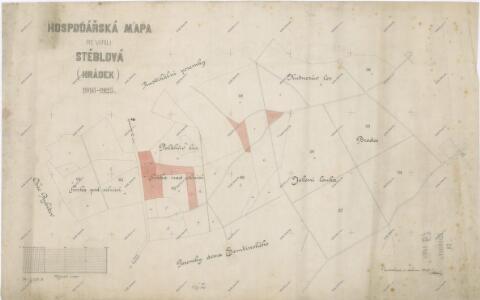
Hospodářská mapa revíru Stéblová, Hrádek 1916-1925
1 : 2880
Porostní mapa lesů Explosie v Semtíně
1 : 5000
Hospodářská mapa polesí Hrádek
1 : 5000
Porostní mapa revíru Hrádek
1 : 2880
Mapa polesí Hrádek
1 : 5000
Indikační skica mapy stabilního katastru pro obec Doubravice I., II.
1 : 2880
Indikační skica mapy stabilního katastru pro město (Lázně) Bohdaneč XI.
1 : 2880
Hospodářská mapa revíru Stéblová
1 : 2880
Mapa propachtovaných pozemků na místě bývalého rybníka Rozkoš
1 : 2880
Síťová mapa pozemků na území bývalého rybníka Rozkoš
1 : 2880
Indikační skica mapy stabilního katastru pro město (Lázně) Bohdaneč X.
1 : 2880
Geometrický plán části revíru Stéblová - Rozkoš
1 : 2880
Indikační skica mapy stabilního katastru pro obec Rybitví II.
1 : 2880
Mapa les a luk na pozemcích bývalého rybníka Rozkoš
1 : 5420
Mapa pozemků oblasti Rozkoš
1 : 2880
Hradek - c2297-1-002 - Kaiserpflichtexemplar der Landkarten des stabilen Katasters
1 : 2880
Hradek - c2297-1-001 - Kaiserpflichtexemplar der Landkarten des stabilen Katasters
1 : 2880
Hospodářská mapa revíru Stéblová, Hrádek 1916-1925
1 : 2880
Porostní mapa revíru Stéblová
1 : 10000
Indikační skica mapy stabilního katastru pro obec Doubravice I.-III.
1 : 2880
Indikační skica mapy stabilního katastru pro město (Lázně) Bohdaneč VII.
1 : 2880
Daubrawitz - c1466-1-001 - Kaiserpflichtexemplar der Landkarten des stabilen Katasters
1 : 2880
Daubrawitz - c1466-1-003 - Kaiserpflichtexemplar der Landkarten des stabilen Katasters
1 : 2880
Daubrawitz - c1466-1-002 - Kaiserpflichtexemplar der Landkarten des stabilen Katasters
1 : 2880
Indikační skica mapy stabilního katastru pro město (Lázně) Bohdaneč I., II.
1 : 2880
Ribitew - c6640-1-002 - Kaiserpflichtexemplar der Landkarten des stabilen Katasters
1 : 2880
Ribitew - c6640-1-003 - Kaiserpflichtexemplar der Landkarten des stabilen Katasters
1 : 2880
Ribitew - c6640-1-001 - Kaiserpflichtexemplar der Landkarten des stabilen Katasters
1 : 2880
Indikační skica mapy stabilního katastru pro obec Rybitví I.
1 : 2880