Maps of Rybitví

Ribitew - c6640-1-002 - Kaiserpflichtexemplar der Landkarten des stabilen Katasters
1 : 2880
Ribitew - c6640-1-003 - Kaiserpflichtexemplar der Landkarten des stabilen Katasters
1 : 2880
Ribitew - c6640-1-001 - Kaiserpflichtexemplar der Landkarten des stabilen Katasters
1 : 2880
Indikační skica mapy stabilního katastru pro obec Rybitví I.
1 : 2880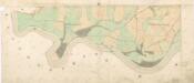
Indikační skica mapy stabilního katastru pro obec Rybitví IV.
1 : 2880
Indikační skica mapy stabilního katastru pro obec Rybitví II.
1 : 2880
Porostní mapa revíru Stéblová
1 : 10000
Srnojed - c7209-1-001 - Kaiserpflichtexemplar der Landkarten des stabilen Katasters
1 : 2880
Srnojed - c7209-1-002 - Kaiserpflichtexemplar der Landkarten des stabilen Katasters
1 : 2880
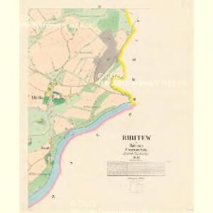
Czerna bei Bohdanecz - c0874-1-001 - Kaiserpflichtexemplar der Landkarten des stabilen Katasters
1 : 2880
Czerna bei Bohdanecz - c0874-1-002 - Kaiserpflichtexemplar der Landkarten des stabilen Katasters
1 : 2880
Indikační skica mapy stabilního katastru pro obec Černá u Bohdanče I.-II.
1 : 2880
Indikační skica mapy stabilního katastru pro obec Černá u Bohdanče II.
1 : 2880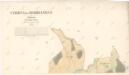
Indikační skica mapy stabilního katastru pro obec Černá u Bohdanče I.
1 : 2880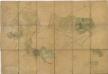
Porostní mapa revíru Stéblová
1 : 10000
Mapa revíru Hrádek
1 : 5000
Porostní mapa revíru Stéblové
1 : 10000
Indikační skica mapy stabilního katastru pro obec Doubravice I.-III.
1 : 2880
Bohdanecz - c0305-1-003 - Kaiserpflichtexemplar der Landkarten des stabilen Katasters
1 : 2880
Bohdanecz - c0305-1-006 - Kaiserpflichtexemplar der Landkarten des stabilen Katasters
1 : 2880
Bohdanecz - c0305-1-002 - Kaiserpflichtexemplar der Landkarten des stabilen Katasters
1 : 2880
Bohdanecz - c0305-1-012 - Kaiserpflichtexemplar der Landkarten des stabilen Katasters
1 : 2880
Bohdanecz - c0305-1-007 - Kaiserpflichtexemplar der Landkarten des stabilen Katasters
1 : 2880
Bohdanecz - c0305-1-010 - Kaiserpflichtexemplar der Landkarten des stabilen Katasters
1 : 2880
Bohdanecz - c0305-1-008 - Kaiserpflichtexemplar der Landkarten des stabilen Katasters
1 : 2880
Bohdanecz - c0305-1-001 - Kaiserpflichtexemplar der Landkarten des stabilen Katasters
1 : 2880
Bohdanecz - c0305-1-009 - Kaiserpflichtexemplar der Landkarten des stabilen Katasters
1 : 2880
Bohdanecz - c0305-1-005 - Kaiserpflichtexemplar der Landkarten des stabilen Katasters
1 : 2880
Bohdanecz - c0305-1-004 - Kaiserpflichtexemplar der Landkarten des stabilen Katasters
1 : 2880