Maps of Černá u Bohdanče

Indikační skica mapy stabilního katastru pro obec Černá u Bohdanče I.-II.
1 : 2880
Czerna bei Bohdanecz - c0874-1-001 - Kaiserpflichtexemplar der Landkarten des stabilen Katasters
1 : 2880
Czerna bei Bohdanecz - c0874-1-002 - Kaiserpflichtexemplar der Landkarten des stabilen Katasters
1 : 2880
Indikační skica mapy stabilního katastru pro obec Černá u Bohdanče II.
1 : 2880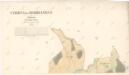
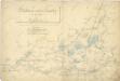
Indikační skica mapy stabilního katastru pro obec Černá u Bohdanče I.
1 : 2880
Indikační skica mapy stabilního katastru pro obec Živanice III.
1 : 2880
Indikační skica mapy stabilního katastru pro obec Živanice I.-V.
1 : 2880
Ziwanitz - c9460-1-001 - Kaiserpflichtexemplar der Landkarten des stabilen Katasters
1 : 2880
Ziwanitz - c9460-1-003 - Kaiserpflichtexemplar der Landkarten des stabilen Katasters
1 : 2880
Ziwanitz - c9460-1-004 - Kaiserpflichtexemplar der Landkarten des stabilen Katasters
1 : 2880
Ziwanitz - c9460-1-002 - Kaiserpflichtexemplar der Landkarten des stabilen Katasters
1 : 2880
Ribitew - c6640-1-002 - Kaiserpflichtexemplar der Landkarten des stabilen Katasters
1 : 2880
Ribitew - c6640-1-003 - Kaiserpflichtexemplar der Landkarten des stabilen Katasters
1 : 2880
Ribitew - c6640-1-001 - Kaiserpflichtexemplar der Landkarten des stabilen Katasters
1 : 2880
Indikační skica mapy stabilního katastru pro město (Lázně) Bohdaneč I., II.
1 : 2880
Laan ob Gruben (Lany na Dulku) - c3804-1-003 - Kaiserpflichtexemplar der Landkarten des stabilen Katasters
1 : 2880
Laan ob Gruben (Lany na Dulku) - c3804-1-001 - Kaiserpflichtexemplar der Landkarten des stabilen Katasters
1 : 2880
Laan ob Gruben (Lany na Dulku) - c3804-1-004 - Kaiserpflichtexemplar der Landkarten des stabilen Katasters
1 : 2880
Laan ob Gruben (Lany na Dulku) - c3804-1-002 - Kaiserpflichtexemplar der Landkarten des stabilen Katasters
1 : 2880
Indikační skica mapy stabilního katastru pro obec Rybitví I.
1 : 2880
Indikační skica mapy stabilního katastru pro obec Neratov a osady Dědek a Novinsko I.-V.
1 : 2880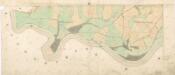
Indikační skica mapy stabilního katastru pro obec Rybitví IV.
1 : 2880
Indikační skica mapy stabilního katastru pro obec Živanice I.
1 : 2880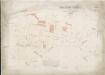
Hospodářská mapa revíru Huneš
1 : 2880
III. vojenské mapování 3955/4
1 : 25000
III. vojenské mapování 3955/4
1 : 25000
III. vojenské mapování 3955/4
1 : 25000
Gradkartenblatt
1 : 25000 Pardubice-oblast (Česko) Hallada, Alois