Maps of Srch

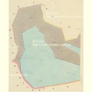
Daubrawitz - c1466-1-001 - Kaiserpflichtexemplar der Landkarten des stabilen Katasters
1 : 2880
Daubrawitz - c1466-1-003 - Kaiserpflichtexemplar der Landkarten des stabilen Katasters
1 : 2880
Daubrawitz - c1466-1-002 - Kaiserpflichtexemplar der Landkarten des stabilen Katasters
1 : 2880
Hospodářská mapa polesí Hrádek
1 : 5000
Mapa polesí Hrádek
1 : 5000
Porostní mapa revíru Hrádek
1 : 2880
Indikační skica mapy stabilního katastru pro obec Doubravice III.
1 : 2880
Indikační skica mapy stabilního katastru pro obec Doubravice I., II.
1 : 2880
Hospodářská mapa revíru Stéblová, Hrádek 1916-1925
1 : 2880
Porostní mapa obecního lesa Doubravického
1 : 2880
Indikační skica mapy stabilního katastru pro obec Trnová I.
1 : 2880
Indikační skica mapy stabilního katastru pro obec Rybitví II.
1 : 2880
Indikační skica mapy stabilního katastru pro obec Pohránov ad II.
1 : 2880
Indikační skica mapy stabilního katastru pro obec Rosice ad II.
1 : 2880
Indikační skica mapy stabilního katastru pro obec Doubravice I.-III.
1 : 2880
Porostní mapa revíru Stéblová
1 : 10000
Porostní mapa lesů Explosie v Semtíně
1 : 5000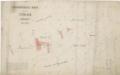
Hospodářská mapa revíru Stéblová, Hrádek 1916-1925
1 : 2880
Rositz (Rosice) - c6538-1-001 - Kaiserpflichtexemplar der Landkarten des stabilen Katasters
1 : 2880
Rositz (Rosice) - c6538-1-002 - Kaiserpflichtexemplar der Landkarten des stabilen Katasters
1 : 2880
Rositz (Rosice) - c6538-1-004 - Kaiserpflichtexemplar der Landkarten des stabilen Katasters
1 : 2880
Rositz (Rosice) - c6538-1-003 - Kaiserpflichtexemplar der Landkarten des stabilen Katasters
1 : 2880
Indikační skica mapy stabilního katastru pro obec Pohránov I.-II.
1 : 2880
Pohranow - c5958-1-002 - Kaiserpflichtexemplar der Landkarten des stabilen Katasters
1 : 2880
Pohranow - c5958-1-001 - Kaiserpflichtexemplar der Landkarten des stabilen Katasters
1 : 2880
Hradek - c2297-1-002 - Kaiserpflichtexemplar der Landkarten des stabilen Katasters
1 : 2880
Hradek - c2297-1-001 - Kaiserpflichtexemplar der Landkarten des stabilen Katasters
1 : 2880
Trnowa - c7978-1-002 - Kaiserpflichtexemplar der Landkarten des stabilen Katasters
1 : 2880
Trnowa - c7978-1-003 - Kaiserpflichtexemplar der Landkarten des stabilen Katasters
1 : 2880