Maps of Kanice

Katastrální mapa obce Kanice
1 : 2880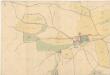
Situační plán budov a pozemků velkostaku Kanice a dvora Příkřice
1 : 2918
Situační plán budov a pozemků velkostaku Kanice a dvora Příkřice
1 : 2918
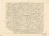
Kanitz (Kanic) - c3037-1-003 - Kaiserpflichtexemplar der Landkarten des stabilen Katasters
1 : 2880
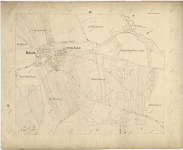
Kanitz (Kanic) - c3037-1-004 - Kaiserpflichtexemplar der Landkarten des stabilen Katasters
1 : 2880
Kanitz (Kanic) - c3037-1-001 - Kaiserpflichtexemplar der Landkarten des stabilen Katasters
1 : 2880
Kanitz (Kanic) - c3037-1-002 - Kaiserpflichtexemplar der Landkarten des stabilen Katasters
1 : 2880
Porostní mapa revíru Hradiště a Kanice
1 : 10000
Kollautschen (Kollowecz) - c3293-1-005 - Kaiserpflichtexemplar der Landkarten des stabilen Katasters
1 : 2880
Kollautschen (Kollowecz) - c3293-1-001 - Kaiserpflichtexemplar der Landkarten des stabilen Katasters
1 : 2880
Kollautschen (Kollowecz) - c3293-1-004 - Kaiserpflichtexemplar der Landkarten des stabilen Katasters
1 : 2880
Kollautschen (Kollowecz) - c3293-1-003 - Kaiserpflichtexemplar der Landkarten des stabilen Katasters
1 : 2880
Kollautschen (Kollowecz) - c3293-1-002 - Kaiserpflichtexemplar der Landkarten des stabilen Katasters
1 : 2880
Kollautschen (Kollowecz) - c3293-1-006 - Kaiserpflichtexemplar der Landkarten des stabilen Katasters
1 : 2880
Speciální hospodářská mapa revíru Kanice - sekce 1
1 : 2880
Hospodářská mapa revíru Kanice
1 : 2880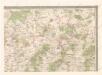
Mapa politického okresu Domažlického


Podrobné mapy zemí Koruny české v měřítku 1:75.000 a mapy vzdáleností všech míst při silnici ležících
1 : 75000 Domažlice (Česko : oblast) Bělohlav, Josef F. Topič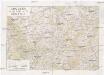
Chodsko
1 : 100000 Chodsko (Česko) Klub českých turistů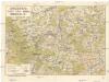
Chodsko
1 : 100000 Chodsko (Česko) Klub českých turistů
Klatovy a okolí
1 : 75000 Klatovy (Česko : oblast) Vojenský zeměpisný ústav
Klatovy a okolí
1 : 75000 Klatovy (Česko : oblast) Vojenský zeměpisný ústav
Klatovy
1 : 75000 Klatovy-oblast (Česko) Vojenský zeměpisný ústav
Klatovy
1 : 75000 Klatovy (Česko : oblast) Vojenský zeměpisný ústav

Domažlice a okolí
1 : 75000 Domažlice (Česko : oblast) Vojenský zeměpisný ústav
Hospodářská mapa revíru Podzámčí
1 : 5835
Taus und Klattau
1 : 75000 Domažlice (Česko : oblast) K. u. k. Militärgeographisches Institut