Maps of Kanice

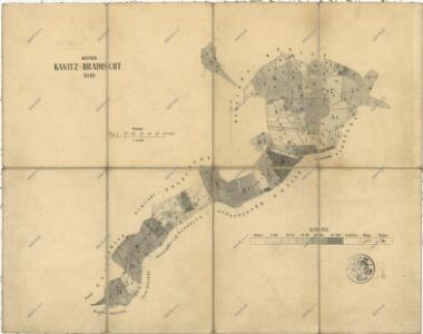
Porostní mapa revíru Hradiště a Kanice
1 : 10000
Hradischt (Hradisstě) - c2310-1-003 - Kaiserpflichtexemplar der Landkarten des stabilen Katasters
1 : 2880
Hradischt (Hradisstě) - c2310-1-004 - Kaiserpflichtexemplar der Landkarten des stabilen Katasters
1 : 2880
Hradischt (Hradisstě) - c2310-1-001 - Kaiserpflichtexemplar der Landkarten des stabilen Katasters
1 : 2880
Hradischt (Hradisstě) - c2310-1-002 - Kaiserpflichtexemplar der Landkarten des stabilen Katasters
1 : 2880
Speciální hospodářská mapa revíru Kanice - sekce 1
1 : 2880
Kanitz (Kanic) - c3037-1-003 - Kaiserpflichtexemplar der Landkarten des stabilen Katasters
1 : 2880
Kanitz (Kanic) - c3037-1-004 - Kaiserpflichtexemplar der Landkarten des stabilen Katasters
1 : 2880
Kanitz (Kanic) - c3037-1-001 - Kaiserpflichtexemplar der Landkarten des stabilen Katasters
1 : 2880
Kanitz (Kanic) - c3037-1-002 - Kaiserpflichtexemplar der Landkarten des stabilen Katasters
1 : 2880
Hospodářská mapa revíru Kanice
1 : 2880
Porostní mapa revíru Hradiště
1 : 2634
Katastrální mapa obce Hradiště
1 : 2880
Katastrální mapa obce Hradiště
1 : 2880
Aulikau (Aulikow) - c8244-1-001 - Kaiserpflichtexemplar der Landkarten des stabilen Katasters
1 : 2880
Aubotschen (Aubočz) - c8164-1-003 - Kaiserpflichtexemplar der Landkarten des stabilen Katasters
1 : 2880
Aubotschen (Aubočz) - c8164-1-001 - Kaiserpflichtexemplar der Landkarten des stabilen Katasters
1 : 2880
Aubotschen (Aubočz) - c8164-1-005 - Kaiserpflichtexemplar der Landkarten des stabilen Katasters
1 : 2880
Aubotschen (Aubočz) - c8164-1-002 - Kaiserpflichtexemplar der Landkarten des stabilen Katasters
1 : 2880
Aubotschen (Aubočz) - c8164-1-004 - Kaiserpflichtexemplar der Landkarten des stabilen Katasters
1 : 2880
Schepadl (Ssepadla) - c8900-1-001 - Kaiserpflichtexemplar der Landkarten des stabilen Katasters
1 : 2880
Schepadl (Ssepadla) - c8900-1-002 - Kaiserpflichtexemplar der Landkarten des stabilen Katasters
1 : 2880
Schepadl (Ssepadla) - c8900-1-003 - Kaiserpflichtexemplar der Landkarten des stabilen Katasters
1 : 2880
Katastrální mapa obce Kanice
1 : 2880
Rzichowitz (Řichowice) - c2396-1-002 - Kaiserpflichtexemplar der Landkarten des stabilen Katasters
1 : 2880
Rzichowitz (Řichowice) - c2396-1-001 - Kaiserpflichtexemplar der Landkarten des stabilen Katasters
1 : 2880
Situační plán budov a pozemků velkostaku Kanice a dvora Příkřice
1 : 2918
Mapa politického okresu Domažlického
Honební mapa panství velkostatku Kout-Trhanov
1 : 25000
Stannetitz (Stanietice) - c7221-1-001 - Kaiserpflichtexemplar der Landkarten des stabilen Katasters
1 : 2880
Stannetitz (Stanietice) - c7221-1-002 - Kaiserpflichtexemplar der Landkarten des stabilen Katasters
1 : 2880