Maps of Kanice

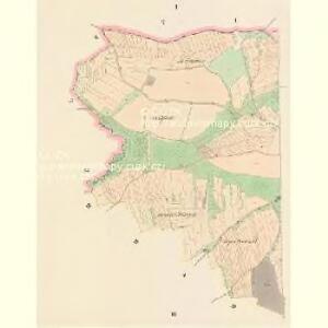
Kanitz (Kanic) - c3037-1-003 - Kaiserpflichtexemplar der Landkarten des stabilen Katasters
1 : 2880
Kanitz (Kanic) - c3037-1-004 - Kaiserpflichtexemplar der Landkarten des stabilen Katasters
1 : 2880
Kanitz (Kanic) - c3037-1-001 - Kaiserpflichtexemplar der Landkarten des stabilen Katasters
1 : 2880
Kanitz (Kanic) - c3037-1-002 - Kaiserpflichtexemplar der Landkarten des stabilen Katasters
1 : 2880
Speciální hospodářská mapa revíru Kanice - sekce 1
1 : 2880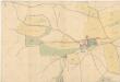
Situační plán budov a pozemků velkostaku Kanice a dvora Příkřice
1 : 2918
Hospodářská mapa revíru Kanice
1 : 2880
Katastrální mapa obce Kanice
1 : 2880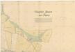
Situační plán budov a pozemků velkostaku Kanice a dvora Příkřice
1 : 2918
Katastrální mapa obce Hradiště
1 : 2880
Porostní mapa revíru Hradiště a Kanice
1 : 10000
Hradischt (Hradisstě) - c2310-1-003 - Kaiserpflichtexemplar der Landkarten des stabilen Katasters
1 : 2880
Hradischt (Hradisstě) - c2310-1-004 - Kaiserpflichtexemplar der Landkarten des stabilen Katasters
1 : 2880
Hradischt (Hradisstě) - c2310-1-001 - Kaiserpflichtexemplar der Landkarten des stabilen Katasters
1 : 2880
Hradischt (Hradisstě) - c2310-1-002 - Kaiserpflichtexemplar der Landkarten des stabilen Katasters
1 : 2880
Elstin - c4277-1-006 - Kaiserpflichtexemplar der Landkarten des stabilen Katasters
1 : 2880
Elstin - c4277-1-001 - Kaiserpflichtexemplar der Landkarten des stabilen Katasters
1 : 2880
Elstin - c4277-1-005 - Kaiserpflichtexemplar der Landkarten des stabilen Katasters
1 : 2880
Elstin - c4277-1-003 - Kaiserpflichtexemplar der Landkarten des stabilen Katasters
1 : 2880
Elstin - c4277-1-004 - Kaiserpflichtexemplar der Landkarten des stabilen Katasters
1 : 2880
Elstin - c4277-1-002 - Kaiserpflichtexemplar der Landkarten des stabilen Katasters
1 : 2880
Aubotschen (Aubočz) - c8164-1-003 - Kaiserpflichtexemplar der Landkarten des stabilen Katasters
1 : 2880
Aubotschen (Aubočz) - c8164-1-001 - Kaiserpflichtexemplar der Landkarten des stabilen Katasters
1 : 2880
Aubotschen (Aubočz) - c8164-1-005 - Kaiserpflichtexemplar der Landkarten des stabilen Katasters
1 : 2880
Aubotschen (Aubočz) - c8164-1-002 - Kaiserpflichtexemplar der Landkarten des stabilen Katasters
1 : 2880
Aubotschen (Aubočz) - c8164-1-004 - Kaiserpflichtexemplar der Landkarten des stabilen Katasters
1 : 2880
Kollautschen (Kollowecz) - c3293-1-005 - Kaiserpflichtexemplar der Landkarten des stabilen Katasters
1 : 2880
Kollautschen (Kollowecz) - c3293-1-001 - Kaiserpflichtexemplar der Landkarten des stabilen Katasters
1 : 2880
Kollautschen (Kollowecz) - c3293-1-004 - Kaiserpflichtexemplar der Landkarten des stabilen Katasters
1 : 2880
Kollautschen (Kollowecz) - c3293-1-003 - Kaiserpflichtexemplar der Landkarten des stabilen Katasters
1 : 2880
Kollautschen (Kollowecz) - c3293-1-002 - Kaiserpflichtexemplar der Landkarten des stabilen Katasters
1 : 2880