Maps of Staré Sedliště

Záměrná mapa dvora Částkov
1 : 2880
Schossenreith - c0799-1-002 - Kaiserpflichtexemplar der Landkarten des stabilen Katasters
1 : 2880
Schossenreith - c0799-1-004 - Kaiserpflichtexemplar der Landkarten des stabilen Katasters
1 : 2880
Schossenreith - c0799-1-003 - Kaiserpflichtexemplar der Landkarten des stabilen Katasters
1 : 2880
Schossenreith - c0799-1-001 - Kaiserpflichtexemplar der Landkarten des stabilen Katasters
1 : 2880
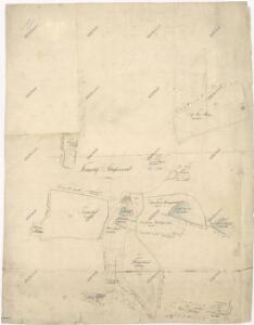
Plán pozemků a rybníků dvora Pořejov
1 : 2632
Situační plán pro hon v Trnové
1 : 25857
Alt Zedlisch - c7275-1-003 - Kaiserpflichtexemplar der Landkarten des stabilen Katasters
1 : 2880
Alt Zedlisch - c7275-1-002 - Kaiserpflichtexemplar der Landkarten des stabilen Katasters
1 : 2880
Alt Zedlisch - c7275-1-005 - Kaiserpflichtexemplar der Landkarten des stabilen Katasters
1 : 2880
Alt Zedlisch - c7275-1-001 - Kaiserpflichtexemplar der Landkarten des stabilen Katasters
1 : 2880
Alt Zedlisch - c7275-1-004 - Kaiserpflichtexemplar der Landkarten des stabilen Katasters
1 : 2880
Alt Zedlisch - c7275-1-006 - Kaiserpflichtexemplar der Landkarten des stabilen Katasters
1 : 2880
Přehledová mapa velkostatku Tachov
1 : 5747
Gross Gropitzreith - c8458-1-003 - Kaiserpflichtexemplar der Landkarten des stabilen Katasters
1 : 2880
Gross Gropitzreith - c8458-1-002 - Kaiserpflichtexemplar der Landkarten des stabilen Katasters
1 : 2880
Gross Gropitzreith - c8458-1-001 - Kaiserpflichtexemplar der Landkarten des stabilen Katasters
1 : 2880
Uschau - c8276-1-003 - Kaiserpflichtexemplar der Landkarten des stabilen Katasters
1 : 2880
Uschau - c8276-1-002 - Kaiserpflichtexemplar der Landkarten des stabilen Katasters
1 : 2880
Uschau - c8276-1-001 - Kaiserpflichtexemplar der Landkarten des stabilen Katasters
1 : 2880
Přehledová mapa dvorů Tisová a Trnová
1 : 6011
Tissa - c7919-1-003 - Kaiserpflichtexemplar der Landkarten des stabilen Katasters
1 : 2880
Tissa - c7919-1-002 - Kaiserpflichtexemplar der Landkarten des stabilen Katasters
1 : 2880
Tissa - c7919-1-001 - Kaiserpflichtexemplar der Landkarten des stabilen Katasters
1 : 2880
Tissa - c7919-1-005 - Kaiserpflichtexemplar der Landkarten des stabilen Katasters
1 : 2880
Tissa - c7919-1-004 - Kaiserpflichtexemplar der Landkarten des stabilen Katasters
1 : 2880
Přehledová mapa velkostatku Tachov
1 : 17280
Hospodářská mapa revíru Kočov
1 : 4350