Maps of Částkov

Přehledová mapa velkostatku Tachov
1 : 5747
Plán pozemků a rybníků dvora Třídvoří
1 : 2561
Gross Gropitzreith - c8458-1-003 - Kaiserpflichtexemplar der Landkarten des stabilen Katasters
1 : 2880
Gross Gropitzreith - c8458-1-002 - Kaiserpflichtexemplar der Landkarten des stabilen Katasters
1 : 2880
Gross Gropitzreith - c8458-1-001 - Kaiserpflichtexemplar der Landkarten des stabilen Katasters
1 : 2880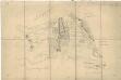
Mapa pozemků mezi obcemi Velký Rapotín, Dlouhý Újezd, Pořejov a Maršovy Chody
1 : 8911
Maschakotten - c4499-1-001 - Kaiserpflichtexemplar der Landkarten des stabilen Katasters
1 : 2880
Maschakotten - c4499-1-002 - Kaiserpflichtexemplar der Landkarten des stabilen Katasters
1 : 2880
Maschakotten - c4499-1-003 - Kaiserpflichtexemplar der Landkarten des stabilen Katasters
1 : 2880
Maschakotten - c4499-1-004 - Kaiserpflichtexemplar der Landkarten des stabilen Katasters
1 : 2880
Langendörflas - c1151-1-002 - Kaiserpflichtexemplar der Landkarten des stabilen Katasters
1 : 2880
Langendörflas - c1151-1-001 - Kaiserpflichtexemplar der Landkarten des stabilen Katasters
1 : 2880
Langendörflas - c1151-1-003 - Kaiserpflichtexemplar der Landkarten des stabilen Katasters
1 : 2880
Langendörflas - c1151-1-005 - Kaiserpflichtexemplar der Landkarten des stabilen Katasters
1 : 2880
Langendörflas - c1151-1-004 - Kaiserpflichtexemplar der Landkarten des stabilen Katasters
1 : 2880
Schossenreith - c0799-1-002 - Kaiserpflichtexemplar der Landkarten des stabilen Katasters
1 : 2880
Schossenreith - c0799-1-004 - Kaiserpflichtexemplar der Landkarten des stabilen Katasters
1 : 2880
Schossenreith - c0799-1-003 - Kaiserpflichtexemplar der Landkarten des stabilen Katasters
1 : 2880
Schossenreith - c0799-1-001 - Kaiserpflichtexemplar der Landkarten des stabilen Katasters
1 : 2880
Záměrná mapa dvora Částkov
1 : 2880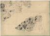
Přehledová mapa velkostatku Tachov
1 : 17280
Porostní mapa revíru Pořejov-Dörflas
1 : 11520
Porostní mapa revíru Pořejov-Dörflas
1 : 11520
Porostní mapa revíru Pořejov, oddělení Dörflas
1 : 9726
Porostní mapa revíru Pořejov-Dörflas
1 : 11520
Porostní mapa revíru Pořejov-Dörflas
1 : 11520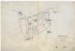
Situační plán pro hon v Trnové
1 : 25857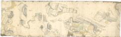
Hospodářská mapa revírů Jedlina, Pořejov a Žebráky
1 : 3256
Uschau - c8276-1-003 - Kaiserpflichtexemplar der Landkarten des stabilen Katasters
1 : 2880
Uschau - c8276-1-002 - Kaiserpflichtexemplar der Landkarten des stabilen Katasters
1 : 2880


