Maps of Hošťka

Plán pozemků a rybníků při dvoře Pořejov
1 : 2659
Katastrální mapa obce Pořejov
1 : 2880
Katastrální mapa obce Pořejov
1 : 2880
Katastrální mapa obce Pořejov
1 : 2880
Purschau - c6024-1-005 - Kaiserpflichtexemplar der Landkarten des stabilen Katasters
1 : 2880
Purschau - c6024-1-002 - Kaiserpflichtexemplar der Landkarten des stabilen Katasters
1 : 2880
Purschau - c6024-1-004 - Kaiserpflichtexemplar der Landkarten des stabilen Katasters
1 : 2880
Purschau - c6024-1-001 - Kaiserpflichtexemplar der Landkarten des stabilen Katasters
1 : 2880
Purschau - c6024-1-003 - Kaiserpflichtexemplar der Landkarten des stabilen Katasters
1 : 2880
Purschau - c6024-1-007 - Kaiserpflichtexemplar der Landkarten des stabilen Katasters
1 : 2880
Purschau - c6024-1-006 - Kaiserpflichtexemplar der Landkarten des stabilen Katasters
1 : 2880
Wosant - c0081-1-001 - Kaiserpflichtexemplar der Landkarten des stabilen Katasters
1 : 2880
Wosant - c0081-1-002 - Kaiserpflichtexemplar der Landkarten des stabilen Katasters
1 : 2880
Wosant - c0081-1-004 - Kaiserpflichtexemplar der Landkarten des stabilen Katasters
1 : 2880
Wosant - c0081-1-003 - Kaiserpflichtexemplar der Landkarten des stabilen Katasters
1 : 2880
Porostní mapa revíru Pořejov, oddělení Dörflas
1 : 9726
Katastrální mapa obce Pořejov
1 : 2880
Hospodářská mapa revíru Pořejov
1 : 5760
Gradkartenblatt
1 : 25000 Rozvadov-oblast (Česko) Bulla, Eduard
Lesní přehledová mapa velkostatku Tachov
1 : 20173
[Kartenblatt]
1 : 25000 Rozvadov (Česko : oblast) Reichsamt für Landesaufnahme

Bestandeskarte des Hauptcomplexes der Domaine Tachau
1 : 29000 Tachov-oblast (Česko) Anderlik, Otto Verlag des böhm. Forstvereins
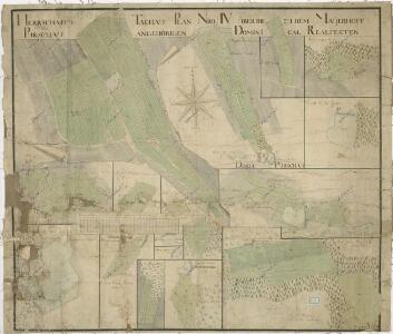
Uibersichtskarte der Herrschaft Tachau
Tachov-oblast (Česko) Waraus, E. André Verlag des böhm. Forstvereins
Hayder Vicariat
Bor-oblast (Tachov, Česko)
Pfraumberg
1 : 75000 Poběžovice (Domažlice, Česko : oblast) Kimlein K. u. k. militär-geographisches Institut
Pfraumberg
1 : 75000 Poběžovice (Domažlice, Česko : oblast) Kimlein K. u. k. Militärgeographisches Institut
Pfraumberg
1 : 75000 Přimda-oblast (Česko) K. u. k. Militärgeographisches Institut
Přehledová mapa velkostatku Tachov
1 : 17280