Maps of Hošťka

Katastrální mapa obce Pořejov
1 : 2880
Plán pozemků a rybníků při dvoře Pořejov
1 : 2659
Purschau - c6024-1-005 - Kaiserpflichtexemplar der Landkarten des stabilen Katasters
1 : 2880
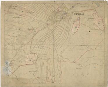
Purschau - c6024-1-002 - Kaiserpflichtexemplar der Landkarten des stabilen Katasters
1 : 2880
Purschau - c6024-1-004 - Kaiserpflichtexemplar der Landkarten des stabilen Katasters
1 : 2880
Purschau - c6024-1-001 - Kaiserpflichtexemplar der Landkarten des stabilen Katasters
1 : 2880
Purschau - c6024-1-003 - Kaiserpflichtexemplar der Landkarten des stabilen Katasters
1 : 2880
Purschau - c6024-1-007 - Kaiserpflichtexemplar der Landkarten des stabilen Katasters
1 : 2880
Purschau - c6024-1-006 - Kaiserpflichtexemplar der Landkarten des stabilen Katasters
1 : 2880
Porostní mapa revíru Pořejov-Dörflas
1 : 11520
Hospodářská mapa revírů Jedlina, Pořejov a Žebráky
1 : 3256
Katastrální mapa obce Žebráky
1 : 2880
Katastrální mapa obce Pořejov
1 : 2880
Přehledová mapa velkostatku Tachov
1 : 17280
III. vojenské mapování 4149/2
1 : 25000
Gradkartenblatt
1 : 25000 Přimda-oblast (Česko) Bulla, Eduard

Bestandeskarte des Hauptcomplexes der Domaine Tachau
1 : 29000 Tachov-oblast (Česko) Anderlik, Otto Verlag des böhm. Forstvereins
Uibersichtskarte der Herrschaft Tachau
Tachov-oblast (Česko) Waraus, E. André Verlag des böhm. Forstvereins
Hayder Vicariat
Bor-oblast (Tachov, Česko)
Pfraumberg
1 : 75000 Poběžovice (Domažlice, Česko : oblast) Kimlein K. u. k. militär-geographisches Institut
Pfraumberg
1 : 75000 Poběžovice (Domažlice, Česko : oblast) Kimlein K. u. k. Militärgeographisches Institut
Pfraumberg
1 : 75000 Přimda-oblast (Česko) K. u. k. Militärgeographisches Institut
Přehledová mapa velkostatku Tachov
1 : 17280
III. vojenské mapování 4149
1 : 75000
Politický okres Tachov
1 : 75000 Tachov (Česko : okres : 1960-) Vojenský zeměpisný ústav
Politický okres Tachov

Podrobná mapa Království českého
1 : 100000 Planá (Tachov, Česko : oblast) Srp, Jan Jaroslav Bursík
Böhmerwald-Verbindungsbahn
1 : 75000 Domažlice-Planá u Mariánských Lázní (Česko : železniční trať) Technisches Bureau Ing. Max Picha