Maps of Kout na Šumavě

Plán dvora Kout
1 : 12000
Mapa pozemků dvora Kout
1 : 2880
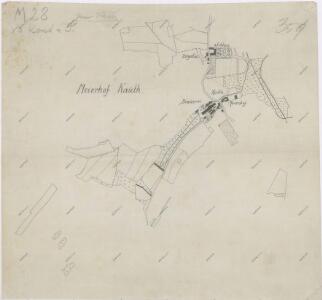
Výsek katastrální mapy obce Kout
1 : 2880
Katastrální mapa obcí Kout a Podzámčí, Nový a Starý Dvůr
1 : 2880
Katastrální mapa obce Kout
1 : 2880
Katastrální mapa obcí Kout a Podzámčí, Nový a Starý Dvůr
1 : 2880
Katastrální mapa obcí Kout a Podzámčí, Nový a Starý Dvůr
1 : 2880
Situační plán nových vodních nádrží v Koutě na Starém potoce
1 : 2880
Výsek katastrální mapy obce Kout
1 : 2880
Kauth (Kauto) - c3429-1-006 - Kaiserpflichtexemplar der Landkarten des stabilen Katasters
1 : 2880
Kauth (Kauto) - c3429-1-002 - Kaiserpflichtexemplar der Landkarten des stabilen Katasters
1 : 2880
Kauth (Kauto) - c3429-1-004 - Kaiserpflichtexemplar der Landkarten des stabilen Katasters
1 : 2880
Kauth (Kauto) - c3429-1-003 - Kaiserpflichtexemplar der Landkarten des stabilen Katasters
1 : 2880
Kauth (Kauto) - c3429-1-008 - Kaiserpflichtexemplar der Landkarten des stabilen Katasters
1 : 2880
Kauth (Kauto) - c3429-1-005 - Kaiserpflichtexemplar der Landkarten des stabilen Katasters
1 : 2880
Kauth (Kauto) - c3429-1-007 - Kaiserpflichtexemplar der Landkarten des stabilen Katasters
1 : 2880
Kauth (Kauto) - c3429-1-001 - Kaiserpflichtexemplar der Landkarten des stabilen Katasters
1 : 2880
Situační plán Nového a Starého Dvora
1 : 11520
Situační plán dvorů Kout, Starý a Nový Dvůr
1 : 7480
Přehledná mapa luk panství Kout
1 : 11257
Mapa pozemků dvorů Kout a Starý Dvůr
1 : 5760
Spaniow (Spaniowo) - c7171-1-003 - Kaiserpflichtexemplar der Landkarten des stabilen Katasters
1 : 2880
Spaniow (Spaniowo) - c7171-1-002 - Kaiserpflichtexemplar der Landkarten des stabilen Katasters
1 : 2880
Spaniow (Spaniowo) - c7171-1-001 - Kaiserpflichtexemplar der Landkarten des stabilen Katasters
1 : 2880
Starz (Starec) - c7256-1-002 - Kaiserpflichtexemplar der Landkarten des stabilen Katasters
1 : 2880
Starz (Starec) - c7256-1-001 - Kaiserpflichtexemplar der Landkarten des stabilen Katasters
1 : 2880
Alt und Neu-Klitschau - c3160-1-005 - Kaiserpflichtexemplar der Landkarten des stabilen Katasters
1 : 2880
Alt und Neu-Klitschau - c3160-1-008 - Kaiserpflichtexemplar der Landkarten des stabilen Katasters
1 : 2880
Alt und Neu-Klitschau - c3160-1-004 - Kaiserpflichtexemplar der Landkarten des stabilen Katasters
1 : 2880
Alt und Neu-Klitschau - c3160-1-006 - Kaiserpflichtexemplar der Landkarten des stabilen Katasters
1 : 2880
Alt und Neu-Klitschau - c3160-1-003 - Kaiserpflichtexemplar der Landkarten des stabilen Katasters
1 : 2880
Alt und Neu-Klitschau - c3160-1-002 - Kaiserpflichtexemplar der Landkarten des stabilen Katasters
1 : 2880
Alt und Neu-Klitschau - c3160-1-001 - Kaiserpflichtexemplar der Landkarten des stabilen Katasters
1 : 2880
Alt und Neu-Klitschau - c3160-1-009 - Kaiserpflichtexemplar der Landkarten des stabilen Katasters
1 : 2880