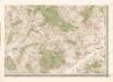
Maps of Kdyně

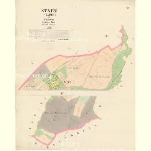
Starz (Starec) - c7256-1-002 - Kaiserpflichtexemplar der Landkarten des stabilen Katasters
1 : 2880
Starz (Starec) - c7256-1-001 - Kaiserpflichtexemplar der Landkarten des stabilen Katasters
1 : 2880
Katastrální mapa obcí Kout a Podzámčí, Nový a Starý Dvůr
1 : 2880
Braunpusch (Praporzisst) - c6083-1-004 - Kaiserpflichtexemplar der Landkarten des stabilen Katasters
1 : 2880
Braunpusch (Praporzisst) - c6083-1-003 - Kaiserpflichtexemplar der Landkarten des stabilen Katasters
1 : 2880
Braunpusch (Praporzisst) - c6083-1-001 - Kaiserpflichtexemplar der Landkarten des stabilen Katasters
1 : 2880
Braunpusch (Praporzisst) - c6083-1-002 - Kaiserpflichtexemplar der Landkarten des stabilen Katasters
1 : 2880
Katastrální mapa obce Brůdek
1 : 2933
Plán meliorace pozemků dvora Bělohrad
1 : 2000
Hospodářský plán statku Bělohrad
1 : 2833
Kauth (Kauto) - c3429-1-006 - Kaiserpflichtexemplar der Landkarten des stabilen Katasters
1 : 2880
Kauth (Kauto) - c3429-1-002 - Kaiserpflichtexemplar der Landkarten des stabilen Katasters
1 : 2880
Kauth (Kauto) - c3429-1-004 - Kaiserpflichtexemplar der Landkarten des stabilen Katasters
1 : 2880
Kauth (Kauto) - c3429-1-003 - Kaiserpflichtexemplar der Landkarten des stabilen Katasters
1 : 2880
Kauth (Kauto) - c3429-1-008 - Kaiserpflichtexemplar der Landkarten des stabilen Katasters
1 : 2880
Kauth (Kauto) - c3429-1-005 - Kaiserpflichtexemplar der Landkarten des stabilen Katasters
1 : 2880
Kauth (Kauto) - c3429-1-007 - Kaiserpflichtexemplar der Landkarten des stabilen Katasters
1 : 2880
Kauth (Kauto) - c3429-1-001 - Kaiserpflichtexemplar der Landkarten des stabilen Katasters
1 : 2880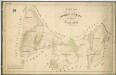
Hospodářská mapa revíru Mlýneček
1 : 5835
Plán dvora Kout
1 : 12000
Situační plán Nového a Starého Dvora
1 : 11520
Katastrální mapa obce Klíčov
1 : 2880
Situační plán dvorů Kout, Starý a Nový Dvůr
1 : 7480
Mapa pozemků dvora Kout
1 : 2880
Přehledná mapa luk panství Kout
1 : 11257
Katastrální mapa obcí Kout a Podzámčí, Nový a Starý Dvůr
1 : 2880
Výsek katastrální mapy obce Kout
1 : 2880
Katastrální mapa obcí Kout a Podzámčí, Nový a Starý Dvůr
1 : 2880
Katastrální mapa obce Kout
1 : 2880