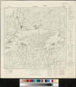
Maps of Brockum

Meßtischblatt 1878, neue Nr. 3516 : Lemförde, 1938
1 : 250000 Lemförde. - Hrsg. 1897, einz. Nachtr. 1938. - 1:25000. - [Berlin]: Reichsamt für Landesaufnahme, 1938. - 1 Kt.
Composite: 284. Lubbecke.
1 : 100000 Reichsamt fur Landesaufnahme
284. Lubbecke.
1 : 100000 Reichsamt fur Landesaufnahme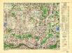
Germany/Central Europe 1:100,000, Minden
Germany / Central Europe 1:100,000, Series GSGS 4416. Great Britain. War Office. [London] : Ordnance Survey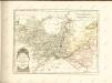

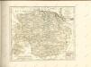
Eveché D'Osnabruc
1 : 170000 Mollova mapová sbírka Le Rouge, Georges-Louis Baisiez Le Rouge, Georges-Louis
Territorii Episcopatvs Osnabrvgensis Tabulae geographica
1 : 160000 Mollova mapová sbírka Gigas, Johann Michael Homann, Johann Baptista - dědici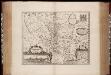
Osnabrugensis episcopatus / auctore Ioanne Gigante ; [Willem Jansz. Blaeu]
1 : 250000 Annotatie: Bij deze 2e staat zijn de lengtegraden in de kaartrand veranderd van O 28°40'-30°20' in O 25°20'-26°50'; Origineel is Blad 77 in atlas factice; Oorspr. uitg.: Atlantis appendix, sive pars altera ... - Amsterdami : apud Guiljelmum Blaeuw, 1630 Gigas, Joannes (1580-1650); Blaeu, Willem Jansz. Amstelodami : Guiljelm. Blaeu excudit [i.e. Joan Blaeu]
Osnabrvgensis Episcopatvs
1 : 470000 Mollova mapová sbírka Gigas, Johann Michael Schenk, Peter I
Osnabrvgensis Episcopatvs
1 : 470000 Mollova mapová sbírka Gigas, Johann Michael
OSNABRVGENSIS | EPISCOPATVS
Auctore Ioanne Gigante. Amstelodami, | Guiljelm. Blaeuw | Excudit
Osnabrugensis Episcopatus. [Karte] Districtus Reckenbergensis. [Nebenkarte], in: Novus atlas absolutissimus, Bd. 2, S. 115.
1 Karte aus Atlas Janssonius Offizin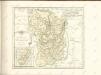
Osnabrugensis Episcopatus. [Karte] Districtus Reckenbergensis. [Nebenkarte], in: Le théâtre du monde, ou, Nouvel atlas contenant les chartes et descriptions de tous les païs de la terre, Bd. 1, S. 166.
1 Karte aus Atlas Blaeu, Willem Janszoon und Blaeu, Joan Blaeu, Willem Janszoon
Osnabrugensis Episcopatus. [Karte] Districtus Reckenbergensis. [Nebenkarte], in: Novus Atlas, das ist, Weltbeschreibung, Bd. 1, S. 135.
1 Karte aus Atlas Blaeu, Joan Blaeu, Willem Janszoon
Osnabrugensis Episcopatus. [Karte] Districtus Reckenbergensis. [Nebenkarte], in: Gerardi Mercatoris et I. Hondii Newer Atlas, oder, Grosses Weltbuch, Bd. 1, S. 170.
1 Karte aus Atlas Mercator, Gerhard und Hondius, Jodocus Jansson, Jan
Minden 57, uit: [W. Liebenow's Special-Karte von Mittel-Europa]
1 : 300000 titelvariant: W. Liebenow's Mittel-Europa; Annotatie: Titel boven de bladen: W. Liebenow's Mittel-Europa Johannes Wilhelm Liebenow 1822-1897 Hannover : Hermann Oppermann
Osnabrvgensis episcopatvs
1 : 236000 Osnabrück (Německo) Gigas, Johann Michael Blaeu, Willem Janszoon Guilielm Blaeuw
Osnabrugensis Episcopatus. [Karte] Districtus Reckenbergergensis. [1 Nebenkarte], in: Theatrum orbis terrarum, sive, Atlas novus, Bd. 1, S. 206.
1 Karte aus Atlas Blaeu, Joan Blaeu, Willem Janszoon
Minden 57, uit: Special-Karte von Mittel-Europa / nach amtlichen Quellen bearbeitet von W. Liebenow
1 : 300000 titelvariant: W. Liebenow's Mittel-Europa; Annotatie: Titel boven de bladen: W. Liebenow's Mittel-Europa Johannes Wilhelm Liebenow 1822-1897 Frankfurt a. M. : Ludwig Ravenstein
Le Theatre de Bellone :
Mollova mapová sbírka Schenk, Pieter Braakman, Adriaan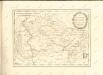

Episcopatvs Monasteriensis Pars Septentrionalis
1 : 290000 Mollova mapová sbírka Gigas, Johann Michael
Episcopatvs Monasteriensis Pars Septentrionalis
1 : 290000 Mollova mapová sbírka Gigas, Johann Michael
Carte topographique d'Allemagne
1 : 225000 Brémy (Německo) Jaeger, Johann Wilhelm Abraham Berndt, Johann Christoph I.W.A. Iaeger
L'Eveché de Munster Le Comté de Bentheim Tecklenbourg Stenford Lingen, Diepholtz Delmenhorst, Ritberg &c.
1 : 420000 Mollova mapová sbírka Le Rouge, Georges-Louis Le Rouge, Georges-Louis
Basse Partie de l'Evesché de Munster, et le Comté de Benthem
1 : 300000 Mollova mapová sbírka Sanson, Guillaume Mortier, Pierre
Monasteriensis et Osnabvrgensis Episcopatvs
1 : 490000 Mollova mapová sbírka Maschop, Gottfried
Rev.mo et Seren.mo Principi ac Domo. Dn. Ferdinando Archiep. et Elect. Colon. Episcop. Monasteriens Leto, Duci Bavariae
Mollova mapová sbírka Gigas, Johann Michael