Maps of Stemwede

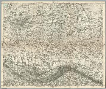
Composite: 284. Lubbecke.
1 : 100000 Reichsamt fur Landesaufnahme
284. Lubbecke.
1 : 100000 Reichsamt fur Landesaufnahme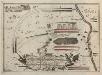
Bataille welche der Herzog Ferdinand über die Franzosische Haupt-Armee ohnweit Minden d. 1. August 1759 mit Ruhm erfochten
1 : 100000
Meßtischblatt 1948 : Hartum, 1898
1 : 250000 Hartum. - Aufn. 1896. - 1:25000. - [Berlin]: Reichsamt für Landesaufnahme, 1898. - 1 Kt.
Meßtischblatt 1947, neue Nr. 3617 : Lübbecke, 1938
1 : 250000 Lübbecke. - Hrsg. 1898, einz. Nachtr. 1938. - 1:25000. - [Berlin]: Reichsamt für Landesaufnahme, 1938. - 1 Kt.
Meßtischblatt 1880 : Diepenau, 1925
1 : 250000 Diepenau. - Aufn. 1896, einz. Nachtr. 1925. - 1:25000. - [Berlin]: Reichsamt für Landesaufnahme, 1925. - 1 Kt.
Meßtischblatt 1879 : Rahden, 1937
1 : 250000 Rahden. - Aufn. 1896, Nachtr. 1919, gedr. [19]37. - 1:25000. - [Berlin]: Reichsamt für Landesaufnahme, 1937. - 1 Kt.
Meßtischblatt 1946, neue Nr. 3616 : Levern, 1938
1 : 250000 Levern. - Hrsg. 1898, einz. Nachtr. 1938. - 1:25000. - [Berlin]: Reichsamt für Landesaufnahme, 1938. - 1 Kt.
Meßtischblatt 1878, neue Nr. 3516 : Lemförde, 1938
1 : 250000 Lemförde. - Hrsg. 1897, einz. Nachtr. 1938. - 1:25000. - [Berlin]: Reichsamt für Landesaufnahme, 1938. - 1 Kt.
Meßtischblatt 2015 : Oeynhausen, 1921
1 : 250000 Oeynhausen. - Aufn. 1896, Nachtr. 1921. - 1:25000. - [Berlin]: Reichsamt für Landesaufnahme, 1921. - 1 Kt.
Meßtischblatt 2015 : Oeynhausen, 1898
1 : 250000 Oeynhausen. - Aufn. 1896. - 1:25000. - [Berlin]: Reichsamt für Landesaufnahme, 1898. - 1 Kt.
Meßtischblatt 2014, neue Nr. 3717 : Quernheim, 1938
1 : 250000 Quernheim. - Hrsg. 1898, einz. Nachtr. 1937/38. - 1:25000. - [Berlin]: Reichsamt für Landesaufnahme, 1938. - 1 Kt.
Meßtischblatt 2014 : Quernheim, 1898
1 : 250000 Quernheim. - Aufn. 1896. - 1:25000. - [Berlin]: Reichsamt für Landesaufnahme, 1898. - 1 Kt.
Meßtischblatt 2013, neue Nr. 3716 : Melle, 1938
1 : 250000 Melle. - Hrsg. 1898, bericht. 1912, einz. Nachtr. 1938. - 1:25000. - [Berlin]: Reichsamt für Landesaufnahme, 1938. - 1 Kt.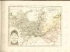
Germany/Central Europe 1:100,000, Minden
Germany / Central Europe 1:100,000, Series GSGS 4416. Great Britain. War Office. [London] : Ordnance Survey
Plan de la bataille de Tonhausen
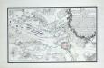
Plan der Battaille bey Minden zwischen der Französ. Armee unter Commando des Mr. des Contades und der Alliirten Armee commandirt von Sr. Durchl. den Herzog Ferdinand von Braunschweig den 1ten Augustus 1759

Meßtischblatt 3619 : Petershagen, 1938
1 : 250000 Petershagen. - Hrsg. 1898, einz. Nachtr. 1938. - 1:25000. - [Berlin]: Reichsamt für Landesaufnahme, 1938. - 1 Kt.
Meßtischblatt 1881 : Uchte, 1937
1 : 250000 Uchte. - Aufn. 1896, Nachtr. 1919, gedr. [19]37. - 1:25000. - [Berlin]: Reichsamt für Landesaufnahme, 1937. - 1 Kt.
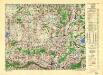
Meßtischblatt 2016 : Minden, 1921
1 : 250000 Minden. - Aufn. 1896, Nachtr. 1921. - 1:25000. - [Berlin]: Reichsamt für Landesaufnahme, 1921. - 1 Kt.
Meßtischblatt 2016 : Minden, 1914
1 : 250000 Minden. - Aufn. 1896, hrsg. 1898, Aufl.-dr. 1914. - 1:25000. - [Berlin]: Reichsamt für Landesaufnahme, 1914. - 1 Kt.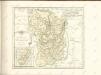

Minden 57, uit: [W. Liebenow's Special-Karte von Mittel-Europa]
1 : 300000 titelvariant: W. Liebenow's Mittel-Europa; Annotatie: Titel boven de bladen: W. Liebenow's Mittel-Europa Johannes Wilhelm Liebenow 1822-1897 Hannover : Hermann Oppermann
Minden 57, uit: Special-Karte von Mittel-Europa / nach amtlichen Quellen bearbeitet von W. Liebenow
1 : 300000 titelvariant: W. Liebenow's Mittel-Europa; Annotatie: Titel boven de bladen: W. Liebenow's Mittel-Europa Johannes Wilhelm Liebenow 1822-1897 Frankfurt a. M. : Ludwig Ravenstein
Osnabrvgensis episcopatvs
1 : 236000 Osnabrück (Německo) Gigas, Johann Michael Blaeu, Willem Janszoon Guilielm Blaeuw
L'Eveché de Munster Le Comté de Bentheim Tecklenbourg Stenford Lingen, Diepholtz Delmenhorst, Ritberg &c.
1 : 420000 Mollova mapová sbírka Le Rouge, Georges-Louis Le Rouge, Georges-Louis
Basse Partie de l'Evesché de Munster, et le Comté de Benthem
1 : 300000 Mollova mapová sbírka Sanson, Guillaume Mortier, Pierre
Osnabrugensis Episcopatus. [Karte] Districtus Reckenbergensis. [Nebenkarte], in: Novus atlas absolutissimus, Bd. 2, S. 115.
1 Karte aus Atlas Janssonius Offizin