Maps of Loccum

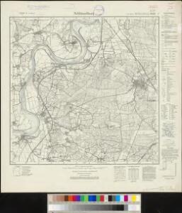
Meßtischblatt 1882 : Schlüsselburg, 1938
1 : 250000 Schlüsselburg. - Hrsg. 1897, einz. Nachtr. 1938. - 1:25000. - [Berlin]: Reichsamt für Landesaufnahme, 1938. - 1 Kt.
Plan de la Bataille de Tonhausen
1 : 100000 Mollova mapová sbírka Bauer, Friedrich Wilhelm von Schley, Jacobus van der Hondt, Pierre de
Composite: 285. Minden.
1 : 100000 Reichsamt fur Landesaufnahme
285. Minden.
1 : 100000 Reichsamt fur Landesaufnahme
Plan de la bataille de Tonhausen
Germany/Central Europe 1:100,000, Minden
Germany / Central Europe 1:100,000, Series GSGS 4416. Great Britain. War Office. [London] : Ordnance Survey

Carte topographique d'Allemagne
1 : 225000 Brémy (Německo) Jaeger, Johann Wilhelm Abraham Berndt, Johann Christoph I.W.A. Iaeger
Episcopatus Hildesiensis Descriptio Novissima [Karte], in: Le théâtre du monde, ou, Nouvel atlas contenant les chartes et descriptions de tous les païs de la terre, Bd. 1, S. 137.
1 Karte aus Atlas Blaeu, Willem Janszoon und Blaeu, Joan Blaeu, Willem Janszoon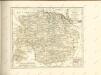

Carta Delli Dvcati di Brvnsvvic, e Lvnebvrg con le loro ad herenze Vescounti, Contee, e Dominy
1 : 370000 Mollova mapová sbírka Hacque, Johann Baptist Hacque, Johann Baptist
DUCATUS BRUNSVICENSIS FEREQUE LUNAEBURGENSIS
1 : 370000 Braunschweig (Německo) Visscher, Claes Jansz. C.I. Visscher excudit
Grossherzogthum Oldenburg und Gebiet der freien Stadt Bremen
Grosser Hand-Atlas über alle Theile der Erde in 170 Karten Meyer, J. Verlag des Bibliographischen Instituts
Die Fürstenthümer Grubenhagen, Calenberg, Wolfenbütel und Blankenburg, welche den südlichen Theil der chur- und fürstl. braunschweig-lüneburgi[schen] Reichsländer begreifen
1 Karte : Kupferdruck ; 46 x 57 cm Güssefeld bey denen Homænnischen Erben
Die Fürstenthümer Grubenhagen, Calenberg, Wolfenbütel und Blankenburg, welche den südlichen Theil der chur- und fürstl. braunschweig-lüneburgi[schen] Reichsländer begreifen
1 Karte : Kupferdruck ; 46 x 57 cm Güssefeld bey denen Homænnischen Erben
Geographische Lage der südlichen Braunschweigischen Reichsgebiete darinnen
1 : 280000 Mollova mapová sbírka Homann, Johann Baptist Homann, Johann Baptista - dědici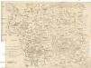
Carta delli dvcati di Brvnsvvic, e Lvnebvrg
1 : 368000 Braunschweig (Německo : historické území)
Ducatus Brunsuicensis
1 : 400000 Braunschweig (Německo : historické území) Homann, Johann Baptist Ioh. Bapt. Homanni
Carte Du Théatre De La Guerre Présente En Westphaliae Avec Les Pays Voisins
1 : 290000 Mollova mapová sbírka Rizzi Zannoni, Giovanni Antonio Back, Jakob Conrad Broenner, Heinrich Ludwig
Ducatus Brunsuicensis in Eiusdem tres Principatus Calenbergicum Scilicet et Grubenhagensem
1 : 360000 Mollova mapová sbírka Wit, Frederik de Covens, Johannes I
Ducatus Brunsuicensis in Eiusdem tres Principatus Calenbergicum Scilicet et Grubenhagensem
1 : 380000 Mollova mapová sbírka Schenk, Pieter Schenk, Peter I
Ducatus Brunsuicensis Episcopatus Hildesiensis Principatus Halberstadiensis Tabula
1 : 370000 Mollova mapová sbírka Danckerts, Justus Danckerts, Justus
Ducatus Brunsuicensis juxta tres suos Principatus Calenbergic. nimir. et Grubenhagens.
1 : 385000 Mollova mapová sbírka Seutter, Matthäus Seutter, Matthäus
Ducatus Brunsuicensis in tres suos Principatus Calenbergicum sc. Grubenhag & Guelpherbitanum distincte divisi, nec non Episcopatus Hildesiensis, Pr. Halber. Comitatus Schauenburgici, aliorumq; confiniorum exacta Tabula
1 : 380000 Mollova mapová sbírka Homann, Johann Baptist Homann, Johann Baptista
Ducatus Brunsuicensis
1 : 375000 Mollova mapová sbírka Homann, Johann Baptist Homann, Johann Baptista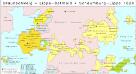
Braunschweig, Lippe-Detmold, Schaumburg-Lippe 1820
Staat Braunschweig, Lippe-Detmold Kunz, Andreas ; Moeschl, Joachim Robert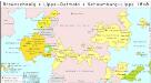
Braunschweig, Lippe-Detmold, Schaumburg-Lippe 1848
Staat Braunschweig, Lippe-Detmold Kunz, Andreas ; Moeschl, Joachim Robert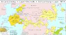
Braunschweig, Lippe-Detmold, Schaumburg-Lippe 1814
Staat Braunschweig, Lippe-Detmold Kunz, Andreas ; Moeschl, Joachim Robert
Ducatus Brunsuicensis
1 : 385000 Braunschweig (Německo : historické území) Seutter, Matthäus sumptibus Matthaei Seutteri