Maps of Kolonowskie

Meßtischblatt 5376 : Grafenweiler, 1938
1 : 250000 Grafenweiler. - Hrsg. 1883, bericht. 1902, einz. Nachtr. 1928, redakt. Änd. [19]38. - 1:25000. - [Berlin]: Reichsamt für Landesaufnahme, 1938. - 1 Kt.
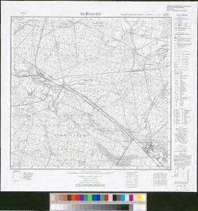
Lublinitz
1 : 75000 K. u. k. Militärgeographisches Institut
135. Lublinitz, uit: Topographische Uebersichtskarte des Deutschen Reiches / herausgegeben v. d. Kartogr. Abt. d. Königl. Preuß. Landesaufnahme
1 : 200000 titelvariant: Topogr. Übersichtskarte des Deutschen Reiches; Annotatie: Titel boven bladen ook: Topogr. Übersichtskarte des Deutschen Reiches; Annotatie geografische gegevens: Op elk blad twee maatstokken: 10 Kilometer = 5,5 cm; 1 geogr. Meile = 3,6 cm; Legenda onder op elk blad Königlich Preußische Landesaufnahme. Kartographische Abtheilung [S.l : Königlich Preußische Landesaufnahme, Kartographische Abtheilung]
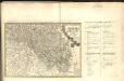
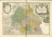
Das Fürstenthum Oppeln in Ober Schlesien
Mollova mapová sbírka Schleuen, Johann David Schleuen, Johann David
Das Fürstenthum Oppeln in Ober Schlesien
1 : 720000 Horní Slezsko Schleuen, Johann David I.D. Schleuen
Beuthen 92, uit: Special-Karte von Mittel-Europa / nach amtlichen Quellen bearbeitet von W. Liebenow
1 : 300000 titelvariant: W. Liebenow's Mittel-Europa; Annotatie: Titel boven de bladen: W. Liebenow's Mittel-Europa Johannes Wilhelm Liebenow 1822-1897 Frankfurt a. M. : Ludwig Ravenstein
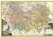
Principatvs Silesiae Rattiboriensis nova et exactissima Tabula geographica commonstrans insimul Liberas Dynastias Ples et Bevthen, cum Statu minore Loslav.
1 : 108000 Mollova mapová sbírka Wieland, Johann Wolfgang Homann, Johann Baptista - dědici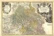
Principatvs Silesiae Oppoloniensis exactissima Tabula geographica, sistens Circvlos Oppoloniensem Ober-Glogav Gros Strehliz, Cosel, Tost, Rosenberg, Falckenberg & Lvblenitz.
1 : 216000 Mollova mapová sbírka Wieland, Johann Wolfgang Homann, Johann Baptista - dědici
Geognostische Karte von Ober-Schlesien
1 : 200000 Dolnoslezské vojvodství (Polsko) Carnall, Rudolph von Simmon Schropp & co.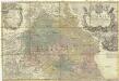
Principatvs Silesiae Oppoliensis
1 : 218000 Opolsko (Polsko) Wieland, Johann Wolfgang Homannianis Heredibus
Granica Polski na Śląsku górnym
1 : 600000 Polsko Instytut kartograficzny Atlas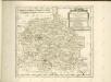

Kartographische Darstellung der Abstimmungs-Ergebnisse von Oberschlesien
1 : 100000 [im Auftrag des Auswärtigen Amtes bearb. in der Plankammer des Preußisch-Statistischen Landesamtes vom Gerke] ; mit Genehmigung der Landesaufnahme, Berlin Berlin : Berliner Lithographisches Institut
III. vojenské mapování 4061
1 : 75000
Mapa Górnego Śląska
1 : 600000 Horní Slezsko Gregor, Józef K. Miarka
Situations Plan der trokenen Landesgraenze zwischen dem Weichsel und Pietruvka Flus von kais. koen. Oesterreich. Schlesien und koen. Preussisch Schlesien
1 : 10000 Visla-oblast (Polsko) Kuffay, Franz Engel
Sect. 21: Breslau, uit: Geologische Karte des Deutschen Reichs in 27 Blaettern / [von] Richard Lepsius ; Red. von C. Vogel
1 : 500000 Annotatie: Blad 18 ontbreekt; Een aantal bladen op linnen; Een aantal bladen gereviseerd 1913-1914; Annotatie geografische gegevens: Met schaalstokken o.a. in kilometers; Legenda Carl Vogel 1828-1897 Gotha : Justus Perthes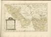

Das souveraine Hertzhogthum Ober- und Nieder-Schlesien nebst den souverainen Grafschaft Glatz, wie solches nach dem Friedens Tractact d. 28. Jüly 1742 an Sc. Königl. Maj. von Preussen von der Königin von Ungarn Maj. auf ewig abgetreten worden
Horní Slezsko Le Rouge, Georges-Louis Schleuen, Johann David Schleuen
Kolonie założone za panowania Fryderyka Wielkiego na Śląsku pruskim
Polen Schlesien Preußen Stadtgründung Friedrich II.
Novissima et accuratissima XVII Provinciarum Germaniae Inferioris Tabula
1 : 1500000 Mollova mapová sbírka Wit, Frederik de Deur, Abraham Janszoon Ottens, Josua
Novissima et accuratissima XVII Provinciarum Germaniae Inferioris Delineatio
1 : 1050000 Mollova mapová sbírka Schagen, Gerhardus Schagen, Gerhardus
Novissima et accuratissima XVII Provinciarum Germaniae Inferioris Delineatio
1 : 1500000 Mollova mapová sbírka Visscher, Nicolaes Deur, Abraham Janszoon Visscher, Nicolaus I.
Germaniae Inferioris XVII Provinciarum Accuratissima Tabula
1 : 1500000 Mollova mapová sbírka Visscher, Nicolaes Jansz. Deur, Abraham Janszoon Visscher, Nicolaus II.
Netz der trigonometrischen Vermessung der Gegend um Neuschloss
Nové Hrady (Ústí nad Orlicí, Česko)
Mapa lesů podle dřevin v protektorátě Čechy a Morava

Karte der Holzartenverbreitung in Protektorat Böhmen und Mähren
Svoboda, Pravdomil