Maps of Solms

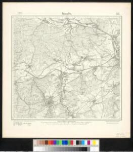
Meßtischblatt 3164 : Braunfels, 1911
1 : 250000 Braunfels. - Aufn. 1890, hrsg. 1892, bericht. 1911. - 1:25000. - [Berlin]: Kgl. Preuss. Landesaufnahme, 1911. - 1 Kt.
Meßtischblatt 3164 : Braunfels, 1892
1 : 250000 Braunfels. - Aufn. 1890. - 1:25000. - [Berlin]: Kgl. Preuss. Landesaufnahme, 1892. - 1 Kt.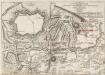
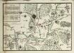
Les Environs de Giesen et de Wetzlar
Plan Von der Stellung der Alliirten Armée unter Commando des Herzogs Ferdinand von Braunschweig, und des Französischen Generals Herzogs von Broglio ohnfern Giesen, vom 18. Septr. 1759. bis den 4. Jan. 1760
Ludwig Wilhelm (Hessen-Homburg, Landgraf)
[26] Sect. Wetzlar, uit: Geologische Karte der Rheinprovinz und der Provinz Westphalen / ausgeführt durch H. von Dechen
1 : 80000 titelvariant: Dechen's geologische Karte vom Rheinland und Westphalen; Annotatie: Titel op bladoverzicht; Incompleet Heinrich von Dechen Berlin : Schropp
Le Flambeau de la Guerre Allumee au Rhin
Mollova mapová sbírka Delisle, Guillaume Schenk, Peter II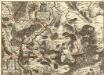
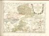
Comitatus Solms: Braunfelsensis et Greiffensteinensis adjacentiumq; quorundam locorum Vera
1 : 70000 Mollova mapová sbírka Simon, Johannes G.
161 Coblenz, uit: Topographische Special-Karte von Deutschland (von Central-Europa) / begründet von D.G. Reymann ; [entworfen und gezeichn. von Heinrich Berghaus... [et al.]]
1 : 200000 Annotatie: Lit.: Daniel Gottlob Reymann und die "Topographische Special-Karte von Deutschland" / von Wolfgang Scharfe, in: Kartographische Nachrichten, 39 (1989), Heft I, p. 1-10; Handgeschreven titel: Reymann's Deutschland : 24 Sectionen: Jena, Penig, Dresden, Zittau, Hirschberg, Breslau, Brieg, Andernach, Coblenz, Giessen, Fulda, Schleusingen, Plauen, Zwickau, Teplitz, Jung Bunzlau, Hohenelbe, Glatz, Neisse, Simmern, Prag, Luxemburg, Birkenfeld; Aanwezig: 23 bladen Reymann, Daniel Gottlob; Berghaus, Heinrich [Berlin : 2. Departement des Kriegsministeriums, Bureau für Plan- und Kartenzeichnung]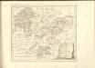

125. Marburg, uit: Topographische Uebersichtskarte des Deutschen Reiches / herausgegeben v. d. Kartogr. Abt. d. Königl. Preuß. Landesaufnahme
1 : 200000 titelvariant: Topogr. Übersichtskarte des Deutschen Reiches; Annotatie: Titel boven bladen ook: Topogr. Übersichtskarte des Deutschen Reiches; Annotatie geografische gegevens: Op elk blad twee maatstokken: 10 Kilometer = 5,5 cm; 1 geogr. Meile = 3,6 cm; Legenda onder op elk blad Königlich Preußische Landesaufnahme. Kartographische Abtheilung [S.l : Königlich Preußische Landesaufnahme, Kartographische Abtheilung]
Section Weilburg, uit: Charte von dem Grossherzogtum Hessen und dem Herzogtum Nassau / trigonometrisch aufgenommen und hrsg. von C.L.P. Eckhardt
1 : 200000 titelvariant: Karte von Hessen und Nassau Eckhardt, C. L. P Darmstadt : Joh. Wilh. Heyer
Wetteravia
1 : 75000 Mollova mapová sbírka Merian, Matthaeus Merian, Matthäus - dědici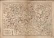
Les Environs De La Lahne depuis Marbvrg iusqu' à Ems avec les pais adiacents
1 : 200000
Wetteravia
1 : 210000 Mollova mapová sbírka Valk, Gerhard Schenk, Peter I
Pars Vederoviae plvrimas ditiones princ. et com. Nassovicor. imprimis verô regionem Schwalbacensem acidulis claram exhibens accurate distincta
Hesensko (Německo) Homann, Johann Baptist J. B. Homann
Pars Vederoviae Plurimas Ditiones Princ. et Com. Nassovicor. imprimis verô Regionem Schwalbacensem Acidulis claram
1 : 170000 Mollova mapová sbírka Homann, Johann Baptist Homann, Johann Baptista
Wetteraviae
1 : 170000 Mollova mapová sbírka Stetter, Johann Jakob Stridbeck, Johann Baur, Johann
Wetteravia die Wetteraw
1 : 210000 Mollova mapová sbírka Pitt, Moses
Mappa geographica exhibens principatum Nassoviae
1 : 172000 Nasavsko Lotter, Tobias Conrad Lotter, Georg F. sumptibus et curis Tobiae Conradi Lotter
Hassiae Svperioris et Wetterav. Partis Delineatio
1 : 170000 Mollova mapová sbírka Bronner, Christian Maximilian Homann, Johann Baptista - dědici
Nassovia principatus, cum omnibus ei pertinentibus comitatibus dominiiis, ac praefecturis, ut et confiniis intrá Lahnum, Rhenum et Moenum flumina
1 : 1500000 ad situm verum exacte delineatus â Joh. Jac. Stetter [...] excudit Nic. Visscheri vidua Amstelodami : nunc apud Petrum Schenk Iunior
Partie Orientale du Temporel, de l'Archevesché et Eslectorat de Treves
1 : 220000 Mollova mapová sbírka Sanson, Guillaume Jaillot, Alexis Hubert
WETTERAVIA. | Vulgo | Die Wetteraw
[Amsterdam : Joan Blaeu]
Wetteravia die Wetteraw.
1 : 210000 Walther, Johann Georg Walther
Wetteravia. die Wetteraw. [Karte], in: Novus atlas absolutissimus, Bd. 2, S. 186.
1 Karte aus Atlas Janssonius Offizin
Wetteraviae Hanc Cum Confiniis Delineationem Serenissimo Principi Ac Domino, D[omi]no Ernesto Ludovico, Hassiae Landgravio, Principi Hersfeldiae, Comiti In Cattimeliboco, Decia, Ziegenhaina, Nidda, Schaumburg, Isemburgo Et Budinga, Etc. Domino suo clementißimo humilimè offert Ioh. Iacob Stetter, I. U. L.
Stetter, Johann Jakob; Stridbeck, Johann Hutter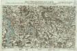
Neue Topographische Carte Der Lahn von Marburg bis zu ihrem Einflus in den Rhein mit Bemerkung der in dieser Gegend vorgefallenen Kriegsbegebenheiten von 1795 und 1796
Brand, Peter; Thum, C.; Schalck, Anna Maria; Coentgen, Georg Joseph Brand u. Thum
Partie Orientale Du Temporel De L'Archevesché et Eslectorat, De Treves
1 : 210000 Mollova mapová sbírka Sanson, Guillaume Jaillot, Alexis Hubert
Nassau, Hessen-Homburg, Frankfurt.
1 : 344000 Flemming, Carl